USGS monitoring on Great Salt Lake brings fresh data on salty water
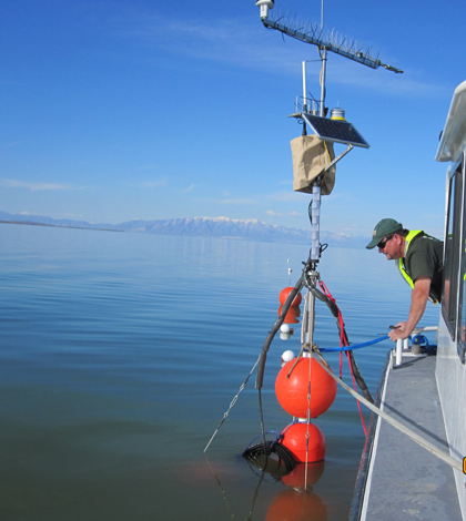
A USGS crew deploying the Lake Environmental Sensing Platform on the Great Salt Lake (Credit: USGS)
The fishless, hypersaline waters of the Great Salt Lake in Utah don’t always engender the greatest enthusiasm for the system amongst the residents along the Wasatch Front.
“Joe Citizen is going to come up and say, ‘It’s a worthless system. There’s no need to even care about Great Salt Lake,” said David Naftz, a research hydrologist with the U.S. Geological Survey. “That’s kind of the attitude you would get from 80 percent if you polled the people that lived around the lake and the Salt Lake Valley.”
But the millions of migratory birds that depend on the lake’s simple food web of brine flies and brine shrimp during their trips to and from South America beg to differ.
“It’s a bird resource of hemispheric importance,” Naftz said. “They’re stopping and they’re getting energy on the Great Salt Lake by eating the brine flies and the brine shrimp that are relatively easy pickings for them.”
The birds are fattening up on a lake with no outflow, a massive surface area that makes it the sixth largest in the United States and water three-to-five times saltier than the ocean. Add to that a list of anthropogenic influences including mining waste and 90 percent of Utah’s treated sewage effluent, and you’ve got a system that behaves unlike any other coping with an increasing contaminant load. To better understand how the lake functions and responds to human-caused stress, the USGS is coordinating monitoring efforts that will help equip managers with unprecedented data.
Though some of the agency’s most advanced monitoring initiatives on the lake have gone into place within the last five years, they’ve operated at lake elevation gauge there since 1938. By taking observations documented by the region’s early pioneers, USGS scientists have back-calculated lake levels to make a long-term record that goes back to the late 1800s.
Since it’s a shallow lake with no natural outflow, water levels are particularly important there.
“The lake elevation just drives so many chemical processes in the lake,” Naftz said. “Because the shoreline gradients are so low in that system, a one-foot drop in lake level can expose thousands of acres of sediment.”
More recent monitoring stations are helping researchers understand how a dense bottom layer of saline water moves throughout the lake and potentially distributes contaminants. Much of that is dependent on a railroad causeway built in the 1950s that splits the lake into north and south arms. Since 90 percent of the freshwater inflow enters the lake’s south arm, the north arm is much saltier, saturated to the point that salt crystals fall out of solution.
")
This photo of the Great Salt Lake from the International Space Station shows the clear division in water quality caused by the railroad causeway (Credit: NASA, via Wikimedia Commons)
The difference in densities between the two arms causes water to flow through a constricted breech in the causeway, which has important effects on the structure of the water column in the south arm.
“You actually get this density-driven flow that’s coming from the north arm that’s diving under the less-saline part of the south arm, and it’s created this kind of permanently stratified layer that has some pretty interesting chemistry going on,” Naftz said.
That chemistry includes mercury concentrations in the lower layer–mostly from atmospheric sources–that rank among the highest ever measured by a USGS lab that sees samples from all over the country, Naftz said.
The USGS monitors the stratification with a Lake Environmental Sensing Platform first moored in the south arm in 2010. The platform supports a string of sensors that measures temperature at 15 depths and specific conductance at three depths. The conductance sensors are suspended near the bottom of the lake and along the interface of the deep brine layer, which tends to line up with the thermocline. That means the researchers can keep an eye on the brine layer by measuring the temperature profile every minute.
Watching the contaminated brine layer is particularly important during sustained wind events that can lead to mixing with the fresh layer, which has implications for how mercury moves through the system.
“It is a very dynamic system when you get some of these seiche events, and you can get some vertical mixing at that density boundary,” Naftz said. “At least our hypothesis is it can move some of the methylated forms of mercury up into the more biologically available water in the lake where it’s more available to the brine shrimp.”
")
An AUV on the Great Salt Lake during a dye tracer study (Credit: USGS)
The USGS is also monitoring how water flows through a fault-related spillway-like structure on the lake bottom south of the causeway. Naftz said high-density water moving through the breach builds up behind the 2-kilometer-wide spillway until a disturbance like high winds sends the dense water over the edge and farther south into the lake. A series of acoustic Doppler velocity meters installed along the structure in 2012 has captured flows of up to a half-meter per second.
“When it’s a 2-kilometer wide structure, you’re moving quite a bit of salinity and other nasty things across that spillway into the more southern portions of the lake,” Naftz said.
The flow data at this spot is especially valuable for managers because the railroad company responsible for the causeway is considering building a second breach, which Naftz said could change the salt balance of the lake significantly. If the second breach goes in, the acoustic instruments will provide a before-and-after picture of how the dynamics of the system have changed.
The Great Salt Lake’s unique water chemistry, geology and human influences have created a system where conventional limnological wisdom doesn’t go very far. The sensing platform, spillway flow stations and other monitoring efforts across the lake are helping to foster a new era of scientific understanding.
“Until the last ten years, there hasn’t been much work on the lake with respect to limnology,” Naftz said. “Just about anything you do or any monitors you put out has likely never been done before.”
Top image: A USGS crew deploying the Lake Environmental Sensing Platform on the Great Salt Lake (Credit: USGS)


0 comments