
USGS sensors track Hurricane Sandy’s storm surge
The storm the media have hyped as the “Frankenstorm” is bearing down on the East Coast, and monitoring technology is feeding critical information on incoming flood water to researchers and homeowners.
The U.S. Geological Survey deployed more than 150 storm surge sensors across the East Coast from the Chesapeake Bay up the coast to Massachusetts, according to a USGS news release. Scientists attached the sensors, which measure water levels every 30 seconds, to places on the eastern shoreline that they hope will be there after the storm.
“Our gauges have shown a three- to four-foot rise over normal heights,” said Brian McCallum, assistant director of the USGS Georgia Water Science Center and a coordinator of the sensor installation effort, on Monday.
McCallum said that water level increase mainly applies to Lower Manhattan, Staten Island and the East River. The Massachusetts coast has also seen a three-foot rise in water levels.
A compilation of existing USGS stream gauge sensors and the newly installed storm-surge sensors will feed data to the USGS Storm-Tide Mapper. The online map regularly updates tracking storm movement and storm surge.
USGS used a similar monitoring system to monitor storm surges from other hurricanes, starting with Hurricane Rita in 2005, according to the USGS release. McCallum said the experience taught USGS scientist how to better logistically plan for a large monitoring effort and how to more quickly relay information to people that need it. One new tactic is the installation of Wi-Fi hot spots in trucks used for sensor installation. This allows those recording data to quickly send out water level measurements so that the Storm-Tide Mapper can be updated.
Around 20 USGS employees have been out in the field installing storm surge sensors since Friday. Teams of two work in sections of each state from Virginia to Maine. The final sensors were installed Monday morning in Maine, McCallum said. A team from Georgia has also been helping the USGS monitoring effort.
McCallum said that storm surges may be at their peak for today, but will intensify with the night’s high tide. A full moon will shine over Hurricane Sandy as it throttles forward tonight, making tidal matters worse. The New York harbor may see a six- to 11-foot storm surge by high tide tonight, according to NASA predictions. North of Surf City, N.C. may see up to six feet of storm surge. Maryland, Connecticut and Rhode Island may see up to eight feet of storm surge by tonight.
Those interested in monitoring inland waterways for flooding from rain caused by Sandy can use USGS’ WaterAlert system. It will connect the user with a stream gauge nearby and can email users when water levels pass safe thresholds.
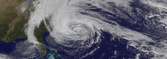
Image: Hurricane Sandy approaching the U.S. East Coast, as captured by the GOES-13 satellite (Credit: NASA Earth Observatory/Robert Simmon)


0 comments