
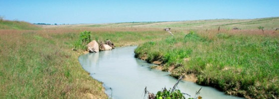
Busseron Creek Watershed Monitoring
Reprinted: YSI Incorporated
As with other watershed monitoring organizations, the Busseron Creek Watershed Partnership (BCWP) exists because of surface water quality degradation. In this case, those waters drain 163,231 acres of a watershed that crosses the boundaries of Vigo, Clay, Green, and Sullivan counties in West-Central Indiana.
Typical to many rural areas of the United States, failing private septic systems and outdated municipal sewage systems dump raw waste into creeks and streams. Like most agricultural regions, surface run-off washes detrimental loads of top soil and phosphorus into streams; sub-surface tile systems conveys nitrogen into the same waters. Flood control projects and management strategies from the 1950s and 1960s exacerbate high rain events and rapid storm water run-off from developed areas, further eroding and contributing to pollutant loads — and stream degradation.
Add to that mix a hundred years’ worth of unregulated coal mining and long-dead mining companies from an era before the Surface Mining Control and Reclamation act of 1977. Acid mine drainage from abandoned mines finds its way into creeks in the Eastern areas of the watershed, lowering pH and raising metal contents. In 2006 and 2007, Total Maximum Daily Load reports indicated that a dramatic reduction of metals — including as much as 100% aluminum, 73% copper, and 96% iron was required to meet Indiana standards.
Compounding these problems are some of the worst poverty levels in Indiana — one county with the worst poverty levels in the state, another with the second to worst personal income levels. Historically an economically disadvantaged area of the state, the area is simply a product of the uses it has met. It has been both blessed and cursed with abundant coal, oil, gas fields, sensitive wetland areas, highly erodible land and a population hamstringed with a lack of financial and technical resources to enable them to address the ongoing natural resource concerns affecting their everyday life.
Perhaps residents of the Busseron Creek area once saw natural resources as assets to be exploited. No longer. The BCWP was formed to manage this initiative for a long-ignored and long-mismanaged area that has only recently attracted State, local, and environmental interest. In December 2007, the Sullivan Co. Soil & Water Conservation District was awarded an EPA Section 319 grant to develop water quality water monitoring strategies, a watershed management plan, an outreach program, and a demonstration project.
The Busseron Creek Monitoring Partnership
Locally, the organization has a small population from which to draw upon — but the BCWP looks far beyond the watershed boundaries for partners. They have sought advice and assistance from organizations across the country — Adapt and Adopt has been a mainstay for BCWP’s development.
Lisa Holscher, project coordinator (and lone paid staff member) for the partnership explained: “We looked at organizations that were very successful that also had areas with issues similar to ours. For example, the 2008 Farm Bill allocated $188 million to the Chesapeake Bay Program; they are obviously doing something right. So, we looked at their structure, their modeling strategies, and how they were addressing the abandoned coal mine sites of Pennsylvania and West Virginia. The help they have provided has been invaluable.”
The Chesapeake Bay Program is just one example of that nationwide search for cooperative assistance. Help has come from State agencies like the Indiana DNR, the South Florida Water Management District and the Missouri Conservation Department and from Federal agencies like the USGS and Department of Interior – Office of Surface Mining. It has come from nongovernmental associations such as the Wabash River Heritage Corridor Commission and the Indiana Water Resources Association. And the list goes on of groups aiding monitoring efforts in the Busseron Creek region.
Said Holscher, “All of these organizations have provided some type of in-kind assistance, most in the category of intellectual property. The bottom line: that’s work we don’t have to do, so our funds can be dedicated to other efforts.”
The BCWP has also been very lucky on a local basis. An office and utilities were donated by the town of Farmersburg. Vincennes University provided a laptop loaded with software, including ArcView. The Sullivan Public Library hosts the group’s website. Those contributions alone have allowed the group to allocate funds for purchase of better field equipment.
“We have an amazing group of volunteers. A retired USGS hydrologist helped design our sampling and monitoring protocol,” Holscher said. A former regional director for Ducks Unlimited has been instrumental in the foundation for our future wildlife and habitat programs.”
“Students from Indiana State University with impressive macroinvertebrate backgrounds will be conducting field assessments,” she continued. “Again, the list goes on, and we want to make the best use of our volunteer’s time and skills, so we started looking at better field equipment.”
 Because weekday sampling further shrinks the pool of potential volunteers, making the best use of time was critical in equipment selection. The group needed an instrument that was both easy to use and would save a great deal of field time. With a very slight learning curve, the YSI 556 handheld multiparameter instrument allows volunteers to accurately and quickly record dissolved oxygen, pH, temperature, and total dissolved solids measurements.
Monitoring Strategy on Busseron Creek
Each month, in addition to the parameters listed above, volunteers measure turbidity and flow, as well as collect samples for lab analysis of Al, Fe, Mn, P, NH3, NO2-NO3, E. coli, and Total Suspended Solids. This data will be combined with ISU’s macro invertebrate surveys and historic information from the Indiana Department of Environmental Management, the USGS, DNR-DOR, as well as data from active mining operations. To further round out the picture of the “State of the Watershed” a widespread collection of habitat assessments has been organized by the Sullivan High School chapter of Future Farmers of America.
Analysis of the data will include GIS modeling to determine priority areas for restoration and preservation. These priority areas will be further defined and classified by land use — with an eye towards long-term financing strategies to underwrite installation and adoption of best management practices (BMP). These categorized priority areas will become the targets for BMP implementation. In turn, BMP programs, practices, and funding will also be classified by land use.
Holscher explained the classification strategy: “People don’t walk in the door and say, ‘I think I have a soil-born phosphorus run-off problem.’ They say ‘I have an 80-acre field just east of the creek. Are there any programs for me?’ They tend to think and talk in terms of land use, so we’re developing a blueprint along those same lines.”
This blueprint for preservation and restoration will be contained in a dynamic watershed management plan. BMPs with a strong and proven return on investment — such as no-till farming, the use of cover crops, and restoration of riparian buffers — will be the group’s primary arsenal. But not the only one. Holscher likes to paraphrase Jim Rogers, CEO of Duke Energy (and environmentalist): “There’s no silver bullet here. What we need is more like silver buckshot.”
The group will continue to monitor water quality to determine the effectiveness of BMPs on the ground. The information will be exported in a database format for further analysis with additional lab tests, updated habitat assessments, and a aquatic life surveys.
According to Holscher, “That’s the clinical side of success. We’ll also be measuring success by reviewing levels of BMP participation – which ones were popular and which ones bombed. It may be the BMP. It may be marketing. Every year, we’ll look at those trends, new funding sources, and newer installation techniques – along with water quality test results – to update and revise the management plan.”
“The adaptability of the plan will be our blueprint for success,” continued Holscher. “We could cry and gnash our teeth about the environmental legacy we’ve inherited. Or we can do something about it. I’m lucky to live in an area and work with people with the latter attitude. We’ll just hitch up our pants and do something about it.”
Image Credit: Peabody Energy


0 comments