NexSens CB-75-SVS Wave Buoy
- Expedited repair and warranty service
- Lifetime technical support
- More
- Measures wave height, period & direction
- Designed for tethered moorings
- Integrated SeaView Systems SVS-603HR wave sensor
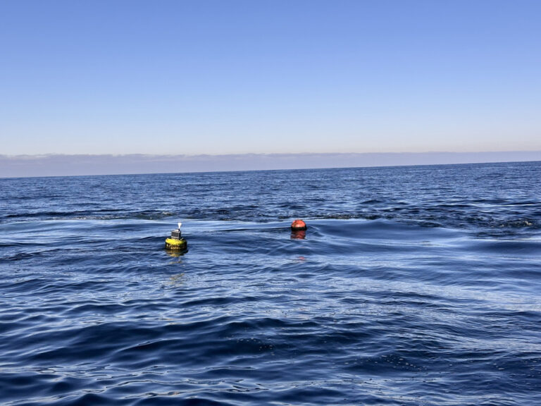
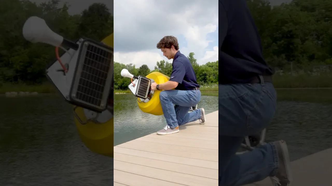
The CB-75-SVS Wave Buoy offers the latest in real-time wave observations in a compact, affordable, and easy to deploy platform. At 21” (53.34cm) hull diameter and 40 lb. (18.14kg) weight, it’s ideally suited for tethered moorings. The buoy accurately measures wave height, period, direction, and more using SeaView Systems’ industry-leading SVS-603HR sensor, relied upon in buoy networks by NOAA and many others throughout the world. External sensor ports with wet-mate connectors support GPS, meteorological, and water quality sensors for maximum flexibility.
The buoy is constructed of an inner core of cross-linked polyethylene foam with a tough polyurea skin. A rechargeable battery with integrated solar panels powers the wave buoy continuously, and all electronics are housed in a quick-removable waterproof package with wet-mate connectors. A removeable instrument cage serves as counter-ballast and supports instrument mounting, while three 1.5” (3.81cm) pass-through holes facilitate cable routing of underwater sensors.
Available with integrated Wi-Fi, 4G LTE or Iridium satellite communications, the CB-75-SVS Wave Buoy sends data in real-time to the cloud-based WQData LIVE datacenter. In the Basic tier, this free service allows users to securely access and analyze data, as well as share data through an auto-report. Subscription-based tiers of WQData LIVE are also available for generating custom alarms, exporting data through an API or custom NDBC/GLOS formats, and providing a publicly-accessible version of the project website.
Wave Sensor: SeaView Systems SVS-603HRi
Parameters: Hs Wave Height (Significant Wave Height), TP (DPD) Wave Period, Dominant Wave Direction, Mean Wave Direction (MWD), Te Energy Period, RMS Tilt Angle, Max Tilt Angle
Range: Wave Height: 0.2-20m; Wave Period: 1-30 seconds; Wave Direction: 0-360°
Resolution: Wave Height: 0.001m; Wave Period: 0.001 seconds; Wave Direction: 0.001°
Accuracy: Wave Height: +/- 0.5cm; Wave Period: <1%; Wave Direction: +/-2°
Buoy: NexSens CB-75
Hull Outer Diameter: 21” (53.34cm)
Hull Height: 13” (33.02cm)
Tower Height: 8.2” (20.83cm)
Solar Panels: 3x 4-watts
Weight: 49 lb. (22.23kg)
Net Buoyancy: 81 lb. (36.74kg)
Tethering Attachments: 3x 3/8” eye nuts
Data Logger: NexSens X3-SVS
Operating Temperature: -40°C to 70°C
Rating: IP68
User Interface: Wireless Bluetooth or wired RS-485 via USB adapter to CONNECT Software; WQData LIVE Web Datacenter with optional wireless telemetry; Status beeps
Real Time Clock (RTC): <30sec/month drift1; Auto-sync weekly2; Internal backup battery
Data Logging: 8 MB non-volatile flash memory; >1 year storage with 20 parameters at 15-minute interval; Max 200 parameters per log interval (170 parameters per instrument)
Log Interval: User configurable (30-minute default minimum)3; Unique interval per sensor
Transmit Interval: User configurable (60-minute default minimum)
Transmission Trigger: Time-based; Selective parameter upload option
Sensor Interfaces: RS-232 (2 Channels), SDI-12, RS-485, Pulse Count
Built-in Sensors: Temperature (-40° to 100°C, 0.016°C resolution, ±0.3°C accuracy); Humidity (0% to 100%, 0.03% resolution, ±4% accuracy from 5 to 95% RH; System voltage; System current; System power; Real-time clock (RTC) battery voltage
Sensor Ports: (2) MCBH-8-MP for sensor interface (RS-232, RS-485, SDI-12, Power, GND)
Power Port: (1) MCBH-6-FS for power and communication (12V Solar In, Power Switch, RS-485 Host, GND)
Telemetry Options: 2.4GHz Wi-Fi (802.11 b/g/n), 4G LTE global cellular, Iridium satellite; includes fallback support
Antenna Port: Type N female
Notes
1Assumes 25ºC operating temperature
2Requires the X3-SVS to be connected to the internet
3Minimum log interval dependent on wave sensor sampling frequency (5-minute, 10-minute, or 20-minute sample duration)
- Measures wave height, period & direction
- Designed for tethered moorings
- Integrated SeaView Systems SVS-603HR wave sensor
The CB-75-SVS Wave Buoy offers the latest in real-time wave observations in a compact, affordable, and easy to deploy platform. At 21” (53.34cm) hull diameter and 40 lb. (18.14kg) weight, it’s ideally suited for tethered moorings. The buoy accurately measures wave height, period, direction, and more using SeaView Systems’ industry-leading SVS-603HR sensor, relied upon in buoy networks by NOAA and many others throughout the world. External sensor ports with wet-mate connectors support GPS, meteorological, and water quality sensors for maximum flexibility.
The buoy is constructed of an inner core of cross-linked polyethylene foam with a tough polyurea skin. A rechargeable battery with integrated solar panels powers the wave buoy continuously, and all electronics are housed in a quick-removable waterproof package with wet-mate connectors. A removeable instrument cage serves as counter-ballast and supports instrument mounting, while three 1.5” (3.81cm) pass-through holes facilitate cable routing of underwater sensors.
Available with integrated Wi-Fi, 4G LTE or Iridium satellite communications, the CB-75-SVS Wave Buoy sends data in real-time to the cloud-based WQData LIVE datacenter. In the Basic tier, this free service allows users to securely access and analyze data, as well as share data through an auto-report. Subscription-based tiers of WQData LIVE are also available for generating custom alarms, exporting data through an API or custom NDBC/GLOS formats, and providing a publicly-accessible version of the project website.
Wave Sensor: SeaView Systems SVS-603HRi
Parameters: Hs Wave Height (Significant Wave Height), TP (DPD) Wave Period, Dominant Wave Direction, Mean Wave Direction (MWD), Te Energy Period, RMS Tilt Angle, Max Tilt Angle
Range: Wave Height: 0.2-20m; Wave Period: 1-30 seconds; Wave Direction: 0-360°
Resolution: Wave Height: 0.001m; Wave Period: 0.001 seconds; Wave Direction: 0.001°
Accuracy: Wave Height: +/- 0.5cm; Wave Period: <1%; Wave Direction: +/-2°
Buoy: NexSens CB-75
Hull Outer Diameter: 21” (53.34cm)
Hull Height: 13” (33.02cm)
Tower Height: 8.2” (20.83cm)
Solar Panels: 3x 4-watts
Weight: 49 lb. (22.23kg)
Net Buoyancy: 81 lb. (36.74kg)
Tethering Attachments: 3x 3/8” eye nuts
Data Logger: NexSens X3-SVS
Operating Temperature: -40°C to 70°C
Rating: IP68
User Interface: Wireless Bluetooth or wired RS-485 via USB adapter to CONNECT Software; WQData LIVE Web Datacenter with optional wireless telemetry; Status beeps
Real Time Clock (RTC): <30sec/month drift1; Auto-sync weekly2; Internal backup battery
Data Logging: 8 MB non-volatile flash memory; >1 year storage with 20 parameters at 15-minute interval; Max 200 parameters per log interval (170 parameters per instrument)
Log Interval: User configurable (30-minute default minimum)3; Unique interval per sensor
Transmit Interval: User configurable (60-minute default minimum)
Transmission Trigger: Time-based; Selective parameter upload option
Sensor Interfaces: RS-232 (2 Channels), SDI-12, RS-485, Pulse Count
Built-in Sensors: Temperature (-40° to 100°C, 0.016°C resolution, ±0.3°C accuracy); Humidity (0% to 100%, 0.03% resolution, ±4% accuracy from 5 to 95% RH; System voltage; System current; System power; Real-time clock (RTC) battery voltage
Sensor Ports: (2) MCBH-8-MP for sensor interface (RS-232, RS-485, SDI-12, Power, GND)
Power Port: (1) MCBH-6-FS for power and communication (12V Solar In, Power Switch, RS-485 Host, GND)
Telemetry Options: 2.4GHz Wi-Fi (802.11 b/g/n), 4G LTE global cellular, Iridium satellite; includes fallback support
Antenna Port: Type N female
Notes
1Assumes 25ºC operating temperature
2Requires the X3-SVS to be connected to the internet
3Minimum log interval dependent on wave sensor sampling frequency (5-minute, 10-minute, or 20-minute sample duration)
Select Options


PRODUCT VIDEOS


Customer Stories