Cellular Data Buoy Supports Lake Erie Algae Research, Public Outreach
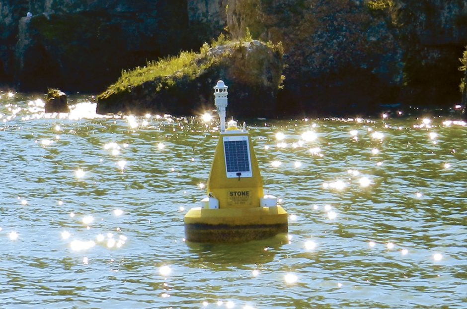
The cellular data buoy near Lake Erie’s Gibraltar Island. (Credit: Nate Christopher / Fondriest Environmental)
Scientists at Ohio State University are at the fore of the fight against harmful algal blooms in Lake Erie. In fact, they deployed a new cellular data buoy off the shore of Gibraltar Island in 2014, months before the Toledo Water Crisis spurred a boom in monitoring platforms around the lake.
That was in part because researchers at the university’s Stone Laboratory, backed by Ohio Sea Grant and housed on Gibraltar, had been seeing a resurgence of blooms in the lake long before international attention came around following the crisis. There was an opportunity, they saw, to continue advancing the mission of research, education and outreach on Lake Erie. The cellular data buoy complimented that in a great way.
While it’s in the water, the NexSens CB-800 data buoy platform donated by Fondriest Environmental helps gather important measurements on weather and water quality. These are achieved through a Lufft WS600 Multi-Parameter Weather Sensor, YSI EXO2 Multi-Parameter Water Quality Sonde (funded by Ohio Sea Grant) and two NexSens T-Node FR thermistors. These connect to a cellular data logger housed within the buoy.
The solar-powered platform is deployed most of the year, but gets pulled in the winter due to ice formation on Lake Erie. During the sampling season, its weather sensor provides measurements on air temperature, barometric pressure, wind speed and direction, humidity and precipitation. The sonde chips in dynamics of water temperature, conductivity, depth, pH, turbidity, dissolved oxygen and total algae. Thermistors track water temperatures at the surface and 1 meter.
The cellular data buoy’s location near the island is key, as it gives scientists an ideal spot for gathering water samples to verify algae data.
“… We can take small boats to the buoy several times a week to collect a water sample adjacent to the buoy and compare that to the data recorded by the buoy,” said Justin Chaffin, research coordinator and senior researcher at Stone Laboratory. “This will allow us to answer the question, ‘How well does the buoy work at tracking blooms?’”
During the 2015 algal bloom, he notes that data on cyanobacteria biomass and that found in water samples were highly correlated. The find is not only good for the buoy near Gibraltar, but others around the lake that carry similar algae-sensing equipment.

Ohio State University researchers get ready to deploy a data buoy near Lake Erie’s Gibraltar Island. (Credit: Ohio Sea Grant)
“We are vetting the buoy measurements against water sample measurements. Initial data suggests that the buoys work very well for tracking cyanobacteria biomass,” said Chaffin. “The next step would be to compare buoy data to water sample microcystin (the toxin produced by cyanobacteria) concentration data. We are researching if buoy data can be used to help predict toxicity of blooms.”
The positive implication from that knowledge is that data buoys serving as early-warning systems for algae blooms near water treatment plant intakes are providing reliable information to drinking water managers. Chaffin notes that the buoy at Stone Laboratory serves as an early-warning system for treatment plants in the Bass Islands region of Lake Erie.
Measurements from the platform are transmitted by the cellular data logger every 15 minutes to a NexSens WQData LIVE web datacenter where researchers can view them in real time. The data are also shared with the Great Lakes Observing System (GLOS) so that scientists around the entire basin may use them.
The GLOS portal also includes data from other buoys and water intake pipes around the basin used by plant operators to adjust treatments as appropriate. Measurements are also posted to the Stone Laboratory website to make another avenue for easy public access.
“The third mission of Stone Lab is public outreach. Every person that visits Gibraltar Island, the island home of Stone Lab, passes by the buoy en route from South Bass Island to Gibraltar Island,” said Chaffin. “This simple piece of the program allows us to show to the public the what, how, and why these data buoys are used by researchers and agencies to track water quality.”
Chaffin notes that data alert the public about conditions in the lake and any algal blooms that are present. Importantly, the measurements also let people know where there is no algae.
“Blooms only occur in a small percentage of the lake for a short duration. Data showing that the lake is bloom-free is just as important as data showing the presence of a bloom,” said Chaffin. “Lake Erie is a great lake, not just in size, but in greatness. It is important to convey the greatness of Lake Erie and not dwell on the blooms.”
Top image: The cellular data buoy near Lake Erie’s Gibraltar Island. (Credit: Nate Christopher / Fondriest Environmental)


0 comments