
Mobile LIDAR enables high resolution vehicle-based mapping
Light Detection and Ranging, commonly used in aerial applications to map the earth, has a new application on the back of a pickup truck.
Michael Olsen, a professor of geomatics at Oregon State University, said vehicle-mounted LIDAR came about inadvertently when engineers were testing a LIDAR application for helicopters in 2006. They had the system mounted to a pickup truck to mimic the way helicopters travel over land. Once mounted and working, they decided to leave the system in place.
Ground-based mobile LIDAR systems change the capabilities of the light ranging and mapping system. The technology looks down on the land from a different perspective, which enhances its view in the short range but limits long-range resolution.
That means within 100 meters of clear land the system can accurately map the Earth’s surface with hundreds to thousands of points per square meter. Aerial LIDAR images, Olsen said, usually have a resolution of only 8 to 60 points per square meter.
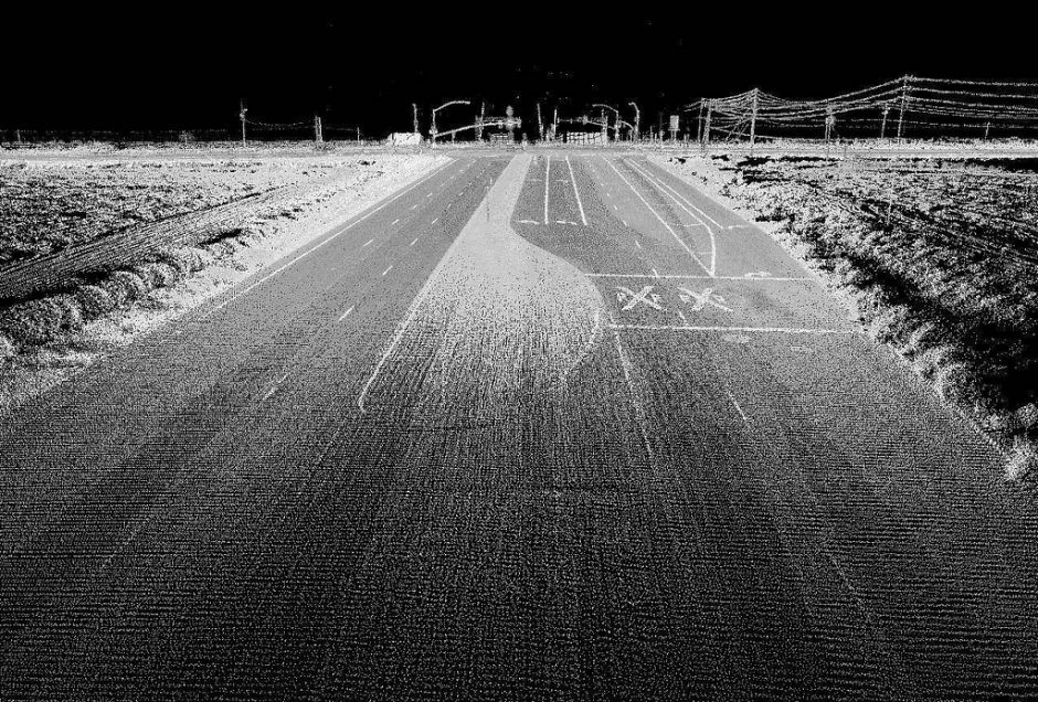
Mobile LIDAR works with a similar principle as plane-based LIDAR. As the vehicle travels across land, the imaging system collects data points that all form a point cloud. All the points add up to an image of the landscape.
For smaller areas with vehicle accessibility, Olsen said, mobile LIDAR is the best and cheapest method for mapping land. It provides a very detailed picture of buildings, trees and even the lines painted on a street.
Olsen said mobile LIDAR can be used in environmental applications to map changes in habitat and land cover. “You can pick up some really subtle changes,” he said. “You can get accuracy down to a few centimeters.”
")
Researchers studying habitat delineation typically make several passes at regular time intervals, comparing each subsequent LIDAR image to a baseline image. Olsen said researchers used mobile LIDAR to analyze changes to the San Diego coastline from erosion and tides. Mobile LIDAR was also used to map the travel path used to transport the Endeavor Space Shuttle through Los Angeles to the California Science Center.
The David Evans and Associates Titan mobile LIDAR system, used to map Los Angeles, is anything but subtle. A hydraulically raised platform fills the truck’s bed. Once raised, the LIDAR system on the platform scans from high above the cab.
Simulations of the shuttle’s movement through the streets, incorporating the mapping from the system, show incredible detail in three dimensions.
Still, Olsen said mobile LIDAR is a new technology and takes a skilled user to get the best images possible. “It’s a very steep learning curve if you are the one to collect the data and process the data and do some analysis with the data,” he said.
Two Transportation Research Board reports explain more detail on mobile LIDAR’s applications to transportation projects. The first details guidelines on its transportation applications. The second delves deeper into mobile LIDAR’s use in specific projects.
Top image: LIDAR can capture considerable data on nearby terrain, as seen in this image of an ordinary highway. (Credit: David Evans and Associates)


0 comments