
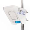
Geolux Non-Contact Surface Velocity Sensor
Features
- Contactless surface velocity measurement
- RS-232, RS-485 Modbus, analog 4-20 mA interfaces in all models
- Robust, small-size IP68 enclosure
- Free ground shipping
- Expedited repair and warranty service
- Lifetime technical support
- More
Overview
The Geolux Non-Contact Surface Velocity Sensor uses radar technology for providing contactless measurement of velocity for water level, flood, and discharge monitoring applications.
Mechanics
Contactless radar technology enables quick and simple sensor installation above the water surface with minimum maintenance. The radar operates in K-band (24.075 GHz to 24.175 GHz) and provides velocity readings 10 times per second over serial RS-232, RS-485 Modbus, and analog 4-20 mA output. The instrument is easily integrated with third-party dataloggers and all of the settings can be remotely configured. An integrated MEMS sensor is used for automatic angle compensation. Internal vibration monitoring and SNR calculation can be used for measurement quality assessment.
General Specifications
Radar Type: K-band 24.075 GHz to 24.175 GHz Doppler radar, 20 dBm EIRP
Beam Angle: 12° Azimuth; 24° Elevation
Detection Distance: Up to 20m above the water
Speed Range: 0.02m/s to 15m/s
Resolution: 0.001m/s
Accuracy: 1%
Sampling Frequency: 10 samples per second
IP Rating: IP68
Electrical & Mechanical
Input Voltage: 9 to 27 VDC
Power Consumption: 950 mW operational, 85 mW standby
Max Current: < 250 mA
Temperature Range: -40 °C to +85 °C (without heating or coolers)
Device Outer Dimensions: 110mm x 90mm x 50mm
Interface
Serial Interface: 1 x serial RS-485 half-duplex; 1 x serial RS-232 (two wire interface)
Serial Baud Rate: 9600 bps to 115200 bps
Serial Protocols: GLX-NMEA, Modbus
Analog Output: 1 x 4-20 mA
Connector: M12 circular 12-pin
Certificates
EN 60950-1:2006+A1:2010+A11:2009+A12:2011+A2:2013
EN 62311:2008
EN 301 489-3 V2.1.1:2019
EN 301 489-1 V2.2.3:2019
EN 61000-6-2:2019
EN 61000-6-3:2021
EN 6100-6-2:2017
EN 300 440 V2.2.1:2018
EN 62368-1:2014+A11:2017
EN 62311:2008
EN 60529:2000+A1:2008+A2:2014 IP68
FCC Part 15 class B
ISED RSS210
Select Options


In The News

From Paddles to Phytoplankton: Studying Vermont’s Wildest Lakes
For six months of the year, Rachel Cray, a third-year PhD student at the Vermont Limnology Laboratory at the University of Vermont, lives between a microscope and her laptop, running data. For the other six months, she is hiking and canoeing four of Vermont’s lakes, collecting bi-weekly water samples. Cray studies algal phenology across four lakes in Vermont, US, that have low anthropogenic stress—or in other words, are very remote. Funded by the National Science Foundation Career Award to Dr. Mindy Morales, the lakes Cray researches part of the Vermont Sentinel Lakes Program, which studies 13 lakes in the area and, in turn, feeds into the Regional Monitoring Network, which operates in the Northeast and Midwest US.
Read More
Reimagining Water Filtration: How Monitoring and Science Enhance FloWater Filtration Systems
Over 50% of Americans think their tap water is unsafe , according to the Environmental Working Group (EWG). Other recent surveys have found that number to be as high as 70% of persons surveyed. Whether due to increased public awareness of water quality issues or confusion about how municipal water sources are regulated, there is a clear distrust of tap water in the United States. According to industry expert Rich Razgaitis, CEO and co-founder of the water purification company FloWater, this issue creates a damaging cycle. Razgaitis explained that the health and environmental problems associated with contaminated water aren’t the only issues. As people become increasingly aware that some tap water is unsafe, they resort to bottled water.
Read More
Monitoring New Hampshire’s Aquatic Ecosystems: Continuous Data Collection in the Lamprey River Watershed
New Hampshire’s aquatic ecosystems provide a range of ecosystem services to the state and region. Resources and services like clean water, carbon storage, climate regulation, nutrient regulation, and opportunities for recreation all depend on New Hampshire’s aquatic ecosystems remaining healthy. Jody Potter, an analytical instrumentation scientist at the University of New Hampshire (UNH), is studying these aquatic ecosystems in hopes of developing an improved understanding of ecosystem services and their interactions with climate change, climate variability, and land use changes. [caption id="attachment_39799" align="alignnone" width="940"] Aquatic sensors in the Merrimack River in Bedford, NH, with I-293 in the background.
Read More