
Juniper Geode GNSS Receivers
- Free ground shipping
- Expedited repair and warranty service
- Lifetime technical support
- More
- Compatible with iOS, Android, and Windows devices
- Intuitive and easy operation, one-button simplicity
- All day battery life for long work days in the field
Scalable Accuracy
The Geode GNS3 provides sub-meter, sub-foot, decimeter and centimeter accuracy options which include SBAS Corrections, RTK, Atlas, and the new Galileo High Accuracy Service.
Open Interface (BYOD)
Use Geode with any of Juniper Systems' handhelds or with your own iPhone™, iPad™, Windows®, or Android™ device.
All-day Battery Life
The Overtime Technology battery provides enough power for long workdays, while conserving power in extreme temperatures.
Simple to Use
It's "one button simple" design provides intuitive and easy operation.
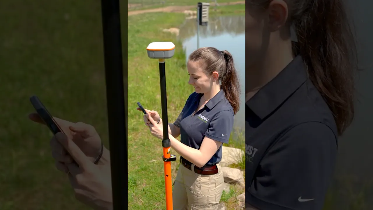
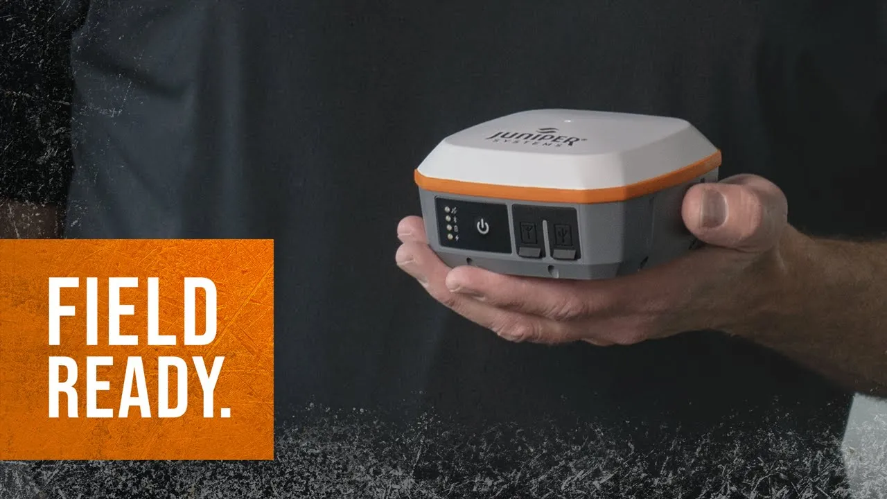
Compact Size
Small and lightweight, the Geode is easy to pack around all day.
All-In-One Design
The inside of the Geode contains the receiver, antenna, and battery, making it easy to carry around and mount without a mess of wires.
Juniper Rugged™
Designed to withstand harsh environments for consistently reliable performance.
Galileo High Accuracy Service (HAS)
The new GNS3H model of the Geode family adds support for the Galileo High Accuracy Service (HAS) to provide free, worldwide 20cm accurate positioning. The Galileo HAS is currently in Initial Phase, meaning that the performance and time standards are currently relaxed so that the EUSPA (European Union Agency for Space Programme) can complete their design and testing to complete the Final Phase of operations with better than 20cm performance in under 5 minutes convergence time (see excluded areas in map below). Simply apply a multi-frequency upgrade to any GNS3H receiver and you have instant access to 20cm real-time location accuracy without any additional subscriptions, downloads or software. The Galileo High Accuracy Service provides precise corrections in the Galileo E6B data signal so that Galileo and GPS signals can achieve real time positioning performance of better than 20cm in nominal conditions. With Galileo HAS, Sub-meter becomes Sub-foot as the new standard for free and open global GNSS positioning.
RECEIVER
- Receiver Type: multi-frequency multi-constellation and L-band capable
- Signals: GPS: L1CA, L1P, L1C, L2P, L12P, L2C, L5,
GLONASS: G1, G2, BeiDou: B1, B2, B3,
GALILEO: E1BC, E5a, E5b, E6b and
QZSS: L1CAm, L1C, L2C, L5 - Channels: 800+
- SBAS Support: 3-channel parallel tracking
- L Band: Atlas worldwide 1525-1560 Mhz
(with subscription) - Update Rate: 1 Hz standard, up to 10Hz and 20 Hz options
- Galileo High Accuracy Service support (GNS3H, with multi-frequency enabled)
ACCURACY
- SBAS: 30 cm HRMS, <60 cm 2DRMS
- RTK: 1 cm RMS
- Atlas (95%): H10:10cm, H30:30 cm, Basic:
50cm (requires subscription)
GALHAS (95%): 20cm - Autonomous: 1.2 meters HRMS
- Cold Start: <60 sec typical (no almanac)
- Reacquisition: 15 sec Atlas, all others <1sec
COMMUNICATIONS
- Bluetooth® 5.1 SPP, IAP2, EAP
- Bluetooth Range: Class 1 Long Range
- Ports: USB Type-C; Serial RS232C DB-9
- Serial Baud Rates: 4800-115200
RECEIVER PROTOCOLS
- Data I/O Protocol: NMEA 0183, Crescent Raw Binary (proprietary)
- Correction I/O Protocol: Hemisphere GNSS
Proprietary, ROX, RTCM v2.3, RTCM v3.2, CMR,
CMR+ - Other: 1PPS Timing Output, Speed Pulse,
Event Marker Input (optional)
POWER
- Input Voltage: 5VDC @ 2A USB
- Power Consumption : 1.7-2 W nominal
- Overtime Technology™ Battery:3.6V 6000 mAh Li-ion (GNS3M/GNS3H) 10 hours, (GNS3S) 16 hours
- Charging Time: Less than 4 hours
ANTENNA
- Internal precision single/multi-frequency with integrated ground plane
- External Antenna Port: MCX type, 50 ohm 15VDC @ 45 mA maximum (GNS3M)/20mA maxiumum (GNS3S)
JUNIPER RUGGED™
- Operating Temp: -20 C to +60 C
- Storage Temp: -30 C to +60 C
- Meets or Exceeds MIL-STD 810G (Drop, Vibration, Temperature, Ingress Protection)
- Enclosure Rating: IP68 (1.4 meters for 30 min)
RECEIVER UPGRADES
- 10 Hz Data Rate
- 20 Hz Data Rate
- Multi-Frequency
- Atlas Basic
- Atlas H30
- Atlas H10
- Athena RTK Engine
DIMENSIONS
- 110x110x57mm (4.36x4.36x2.5in)
- GNS3S Weight: 365g (12.9oz)
- GNS3M/GNS3H Weight: 405g (14.3oz)
- Mount: ¼ x 20 camera stud and M4 AMPS diagonal
GEODE GNS3 COMPATIBILITY
- GeodeConnect™ software provides configuration, communications setup, and receiver settings
- Windows® 10/11
- Android™ 8 and above
- iPhone and iPad
- (1) Geode GNSS receiver with integrated antenna and battery
- (1) USB Type-C to USB Type-C cable
- (1) 5/8 x 11 pole mount adapter
- (1) USB charger
- Compatible with iOS, Android, and Windows devices
- Intuitive and easy operation, one-button simplicity
- All day battery life for long work days in the field
Scalable Accuracy
The Geode GNS3 provides sub-meter, sub-foot, decimeter and centimeter accuracy options which include SBAS Corrections, RTK, Atlas, and the new Galileo High Accuracy Service.
Open Interface (BYOD)
Use Geode with any of Juniper Systems' handhelds or with your own iPhone™, iPad™, Windows®, or Android™ device.
All-day Battery Life
The Overtime Technology battery provides enough power for long workdays, while conserving power in extreme temperatures.
Simple to Use
It's "one button simple" design provides intuitive and easy operation.
Compact Size
Small and lightweight, the Geode is easy to pack around all day.
All-In-One Design
The inside of the Geode contains the receiver, antenna, and battery, making it easy to carry around and mount without a mess of wires.
Juniper Rugged™
Designed to withstand harsh environments for consistently reliable performance.
Galileo High Accuracy Service (HAS)
The new GNS3H model of the Geode family adds support for the Galileo High Accuracy Service (HAS) to provide free, worldwide 20cm accurate positioning. The Galileo HAS is currently in Initial Phase, meaning that the performance and time standards are currently relaxed so that the EUSPA (European Union Agency for Space Programme) can complete their design and testing to complete the Final Phase of operations with better than 20cm performance in under 5 minutes convergence time (see excluded areas in map below). Simply apply a multi-frequency upgrade to any GNS3H receiver and you have instant access to 20cm real-time location accuracy without any additional subscriptions, downloads or software. The Galileo High Accuracy Service provides precise corrections in the Galileo E6B data signal so that Galileo and GPS signals can achieve real time positioning performance of better than 20cm in nominal conditions. With Galileo HAS, Sub-meter becomes Sub-foot as the new standard for free and open global GNSS positioning.
RECEIVER
- Receiver Type: multi-frequency multi-constellation and L-band capable
- Signals: GPS: L1CA, L1P, L1C, L2P, L12P, L2C, L5,
GLONASS: G1, G2, BeiDou: B1, B2, B3,
GALILEO: E1BC, E5a, E5b, E6b and
QZSS: L1CAm, L1C, L2C, L5 - Channels: 800+
- SBAS Support: 3-channel parallel tracking
- L Band: Atlas worldwide 1525-1560 Mhz
(with subscription) - Update Rate: 1 Hz standard, up to 10Hz and 20 Hz options
- Galileo High Accuracy Service support (GNS3H, with multi-frequency enabled)
ACCURACY
- SBAS: 30 cm HRMS, <60 cm 2DRMS
- RTK: 1 cm RMS
- Atlas (95%): H10:10cm, H30:30 cm, Basic:
50cm (requires subscription)
GALHAS (95%): 20cm - Autonomous: 1.2 meters HRMS
- Cold Start: <60 sec typical (no almanac)
- Reacquisition: 15 sec Atlas, all others <1sec
COMMUNICATIONS
- Bluetooth® 5.1 SPP, IAP2, EAP
- Bluetooth Range: Class 1 Long Range
- Ports: USB Type-C; Serial RS232C DB-9
- Serial Baud Rates: 4800-115200
RECEIVER PROTOCOLS
- Data I/O Protocol: NMEA 0183, Crescent Raw Binary (proprietary)
- Correction I/O Protocol: Hemisphere GNSS
Proprietary, ROX, RTCM v2.3, RTCM v3.2, CMR,
CMR+ - Other: 1PPS Timing Output, Speed Pulse,
Event Marker Input (optional)
POWER
- Input Voltage: 5VDC @ 2A USB
- Power Consumption : 1.7-2 W nominal
- Overtime Technology™ Battery:3.6V 6000 mAh Li-ion (GNS3M/GNS3H) 10 hours, (GNS3S) 16 hours
- Charging Time: Less than 4 hours
ANTENNA
- Internal precision single/multi-frequency with integrated ground plane
- External Antenna Port: MCX type, 50 ohm 15VDC @ 45 mA maximum (GNS3M)/20mA maxiumum (GNS3S)
JUNIPER RUGGED™
- Operating Temp: -20 C to +60 C
- Storage Temp: -30 C to +60 C
- Meets or Exceeds MIL-STD 810G (Drop, Vibration, Temperature, Ingress Protection)
- Enclosure Rating: IP68 (1.4 meters for 30 min)
RECEIVER UPGRADES
- 10 Hz Data Rate
- 20 Hz Data Rate
- Multi-Frequency
- Atlas Basic
- Atlas H30
- Atlas H10
- Athena RTK Engine
DIMENSIONS
- 110x110x57mm (4.36x4.36x2.5in)
- GNS3S Weight: 365g (12.9oz)
- GNS3M/GNS3H Weight: 405g (14.3oz)
- Mount: ¼ x 20 camera stud and M4 AMPS diagonal
GEODE GNS3 COMPATIBILITY
- GeodeConnect™ software provides configuration, communications setup, and receiver settings
- Windows® 10/11
- Android™ 8 and above
- iPhone and iPad
- (1) Geode GNSS receiver with integrated antenna and battery
- (1) USB Type-C to USB Type-C cable
- (1) 5/8 x 11 pole mount adapter
- (1) USB charger
Select Options


PRODUCT VIDEOS


Customer Stories


