Wildfire Prevention in the Sierra Nevada Region with the Yuba Watershed Institute
Though recent wildfires have sparked new conversations about wildfire management and response, groups like the Yuba Watershed Institute have been monitoring the forests and water resources of the Sierra Nevada region for decades, managing approximately 5,000 acres of land with the Bureau of Land Management (BLM) and about 7,000 acres in private land partnerships.
The goal of the Institute is to work with local communities and land agencies to improve watershed and forestry management through informed practices and public outreach. The goals of the Yuba Watershed Institute are three-fold:
- Improve the ability of fire suppression agencies like the California Department of Forestry and Fire Protection (CAL FIRE) and the US Forest Service.
- Improve safety for nearby residents by working within the wildland urban interface.
- Improve the resilience of areas outside of the wildland-urban interface.
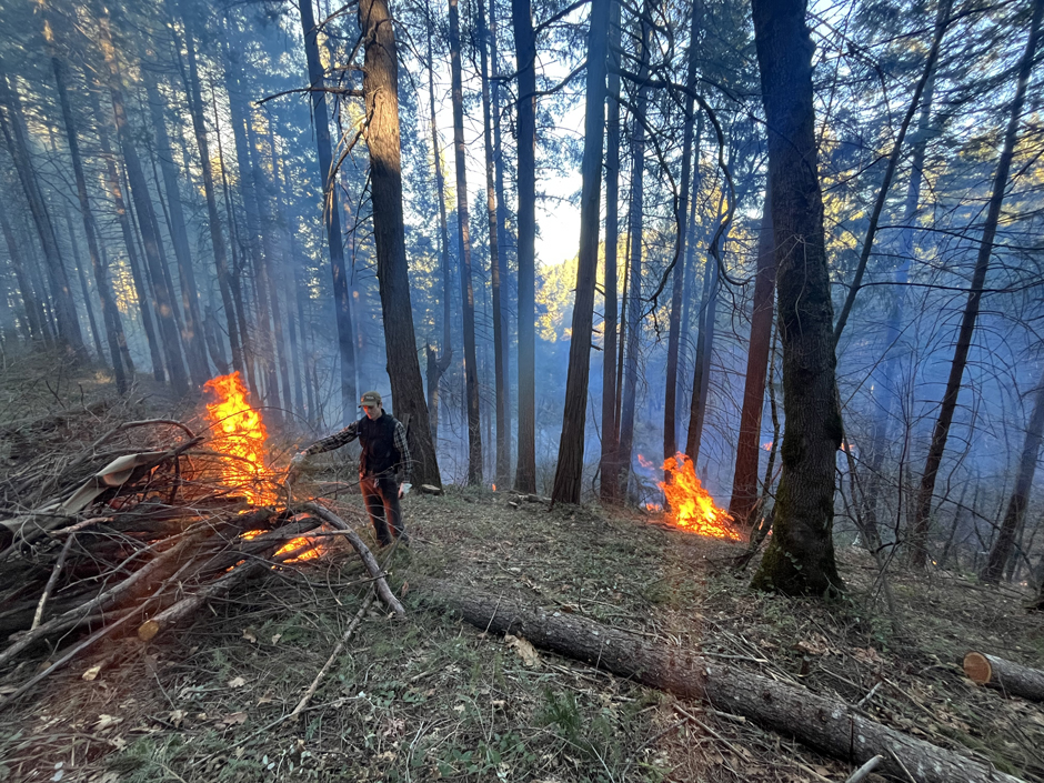
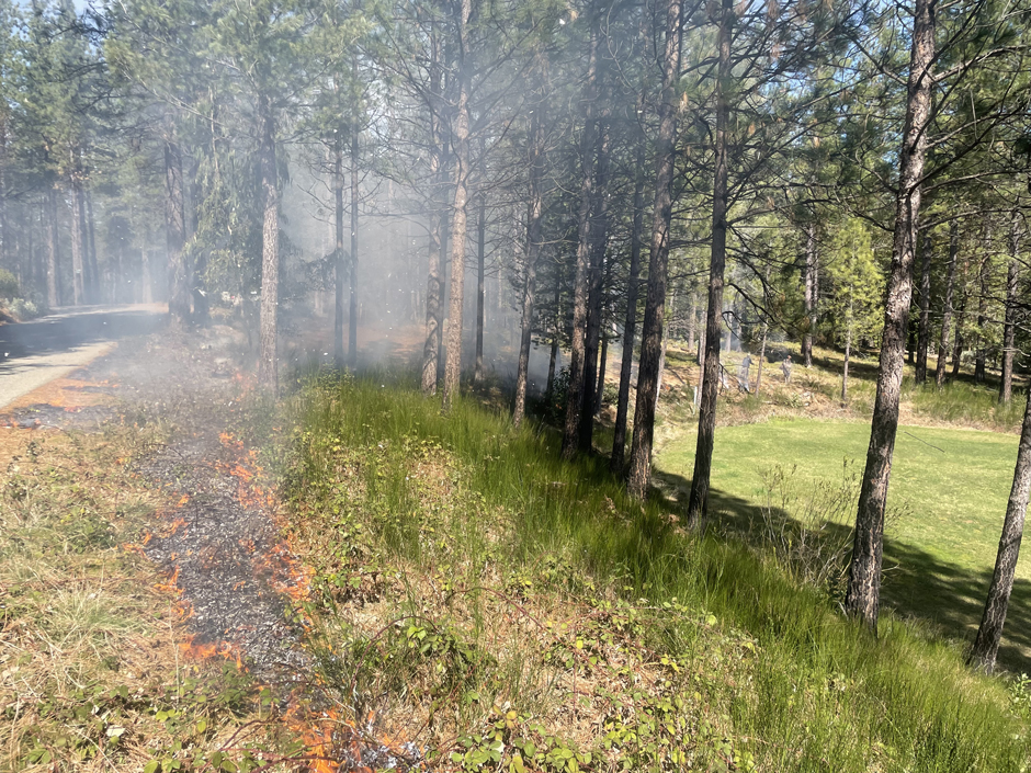
A local prescribed fire crew (First Rain Land Stewardship) burning piles at the Yuba Watershed Institute’s Little Deer Creek Landscape Resilience Project. (Credit: Jesse Gruenberg)
Mimicking Wildfires and Minimizing Impacts
Historically, the Sierra Nevada region experienced smaller-scale wildfires every 10-15 years, but there hasn’t been a major fire in most of the Yuba River watershed in over 100 years, leaving the ecosystem out of balance and increasing the risk for even more severe burns.
As a result, the Yuba Watershed Institute’s goal is to go into these areas and remove excess fuels and vegetation in the same way a wildfire might in order to minimize the extent and severity of future burns.
Chris Friedel, Executive Director of the Yuba Watershed Institute, explains, “We’re trying to get in and mimic wildfire and, where we can, re-establish a more natural fire regime to try to open up the forest and make it more resilient.”
Fuel removal techniques fall under two categories: understory fuels reduction and stand management.
Understory fuel reduction includes removing many small-diameter trees and shrubs, with a focus on removing shade-tolerant species like incense cedar and Douglas fir, as these species would not be present in most areas under a normal fire regime.
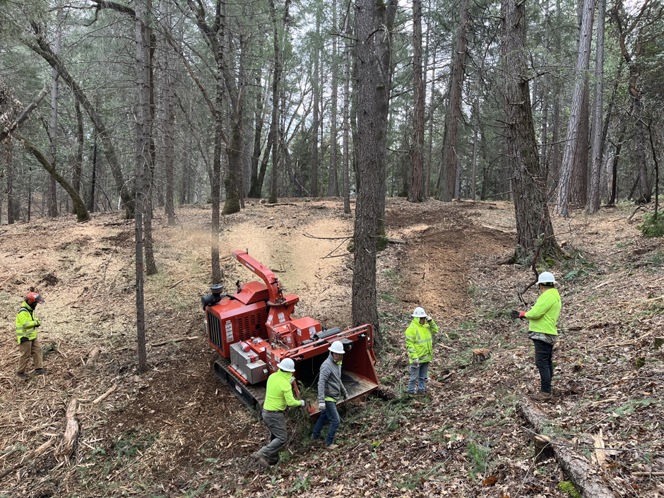
A local contractor (GP Land Development and Clearing) chips cut material at the Yuba Watershed Institute’s Little Deer Creek Landscape Resilience Project. (Credit: Ben Hout)
Most of these removals are done through manual treatments like chainsaws, burn piles, prescribed fire, or chipping, or through mechanical mastication.
In contrast, stand management involves looking at the overstory of the forest, reducing overall canopy density, and removing suppressed, diseased, dead, and dying trees, which helps reduce the risk of crown fires. Once removed, the Yuba Watershed Institute works with BLM to sell the removed logs
The Institute is also looking into prescribed herbivory, which involves the use of goats or sheep to reduce fuels in certain areas, as well as controlled use of herbicides in some areas.
“It’s really kind of all the tools in the toolbox, and I think that’s what makes us different. We’re really trying to do it in a way that balances this type of treatment with protection of biodiversity,” states Friedel.
He continues, “We’ve had a focus on biodiversity since the founding of the organization, and so we try to be really sensitive to things like wildlife, habitat, special status species, soil impacts, and other unintended consequences of this type of work.”
First Rain Land Stewardship crew removing invasive Scotch broom from BLM lands near a local school. (Credit: Tim Van Wagner)
Identifying Areas for Treatment
Before any of these treatments can begin, the Yuba Watershed Institute identifies areas for treatment. Most of their work starts from the ground up, with someone from a community contacting them due to concerns about local land management, or a local/regional fire agency like CAL FIRE will ask for assistance from smaller groups for help on a project.
An example of one of these CAL FIRE partnerships is the South Yuba Rim Hazardous Fuels Reduction project, which covers about 9,000 acres of federal and private lands. The project is a collaboration between the Yuba Watershed Institute and the Nevada County Office of Emergency Services.
The group is currently reviewing various platforms that might identify gaps in treatment areas, as well as various modeling tools like the Forest Services, LandFire data set, and mapping services like USGS Lidar data.
“There’s just a wealth of information that you can get from those LIDAR data sets that helps us understand the land form and what types of equipment and access can happen where,” states Friedel.
He continues, “We can also get some vegetation information from the LIDAR. We can create a canopy height model, which allows us to understand the different vegetation types that are out there, as well as some information on fuel densities, so that’s been incredibly helpful for me when I plan projects.”
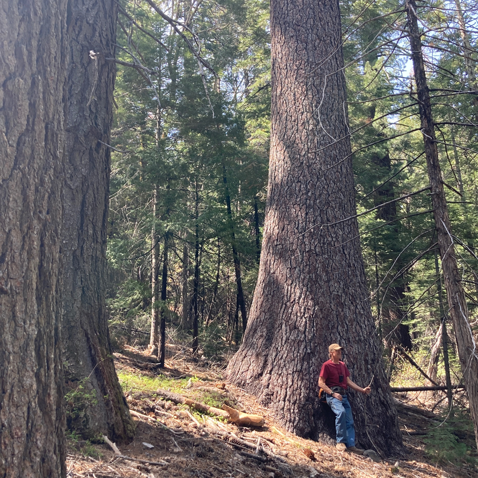
A member of the Yuba Watershed Institute board of directors (Bob Erickson) in one of the last remaining old-growth mixed conifer groves in the region. (Credit: Chris Friedel)
Once the overall area in need of intervention is identified, Friedel’s team uses a Juniper Geode to map out the public land for treatment. BLM-managed lands are normally isolated parcels surrounded by private land, which the institute may not have access to for treatment.
The sub-meter accuracy of the Geode allows the team to accurately map out the treatment zone and ensure they aren’t infringing on private property. Some areas included in the project have dense canopies or are located in canyons where other GNSS receivers the team has used have struggled, but the Geode offers more consistent and accurate data.
Aside from drawing out the property lines, the team also flags different unit boundaries, riparian areas, equipment limitation zones, and maps completed treatments. Treatment data is reported to funding agencies, and the Yuba Watershed Institute makes internal notes of rare plant species locations and the presence of invasive species, improving their existing wetland and stream corridors maps.
“We build a data set for every project that allows us to make sure we’re protecting resources and implementing the project in the right way,” states Friedel.
He continues, “We’re really trying to figure out some best management practices for our area—and our work is definitely not happening in isolation. We’re part of a loose network of different agencies, municipalities, private companies, and nonprofit organizations that are all working on the same types of issues.”
A key part of figuring out these best practices is moving toward a data-center approach to identifying treatment areas, which the CAL FIRE partnership offers the opportunity to work with various data sources and test different strategies to improve land management.
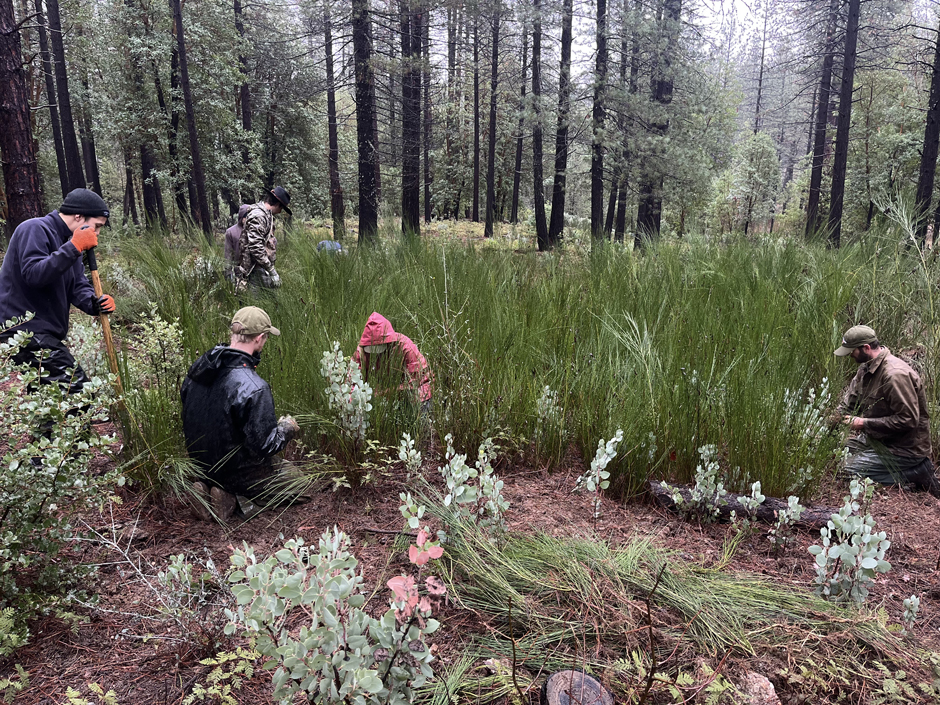
A spring prescribed burn to control the invasive plant Scotch broom. (Credit: Tim Van Wagner)
The Public Component of Watershed Management
According to Friedel, in the Sierra Nevada and California region, it’s not a question of if fire is going to happen—it’s a question of when. Knowing how severe these fires can be without the appropriate intervention, collaboration with other fire prevention and response agencies to develop informed management practices and minimize the risk of wildfires is essential.
“We’re all starting to realize that if we don’t put fire in the landscape ourselves with prescribed fire, or do other types of activities that mimic the role of fire in the landscape, then we’re going to have natural wildfire, and it’s probably going to have effects that are not what we want to see,” explains Friedel.
He continues, “The goal—even though this is very hard sometimes to actually accomplish—is to try to have either prescribed fire or some other kind of fuels reduction activity happen every 5 to 10 years in all these areas that we’re managing […] and how we get there and whether there’s enough funding, and whether the funding matches up with the timeline that we want, that’s another question.”
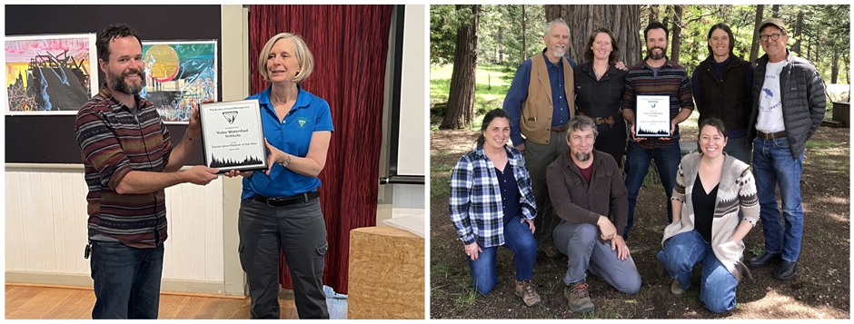
(Left) Chris Friedel, Yuba Watershed Institute Executive Director, accepts the U.S. BLM 2023 Conservation Partner of the Year award from BLM California state director Karen Mouritsen. (Right) Yuba Watershed Institute staff and directors, from left to right. Front row: Ann Hobbs, Daniel Nicholson, Corinne Munger. Back row: Kurt Lorenz, Amber Cone, Chris Friedel, Denise Della Santina, Bob Erickson. (Credit: Yuba Watershed Institute)
Without intervention, millions of residents in the area would be impacted, and so listening to their concerns about land use and developing a culture of stewardship for the watershed is a key component of the Institute’s work.
Part of fostering this culture of stewardship is in sharing projects with the public and hosting public events that allow them to engage more deeply with various parts of the watershed, from the flora and fauna that live there to the landscape itself.
“People are very understandably concerned and afraid of a large-scale uncontrolled wildfire and what kind of effects it would have on this community. […] We are playing a part in helping to make our community more safe and resilient,” states Friedel.
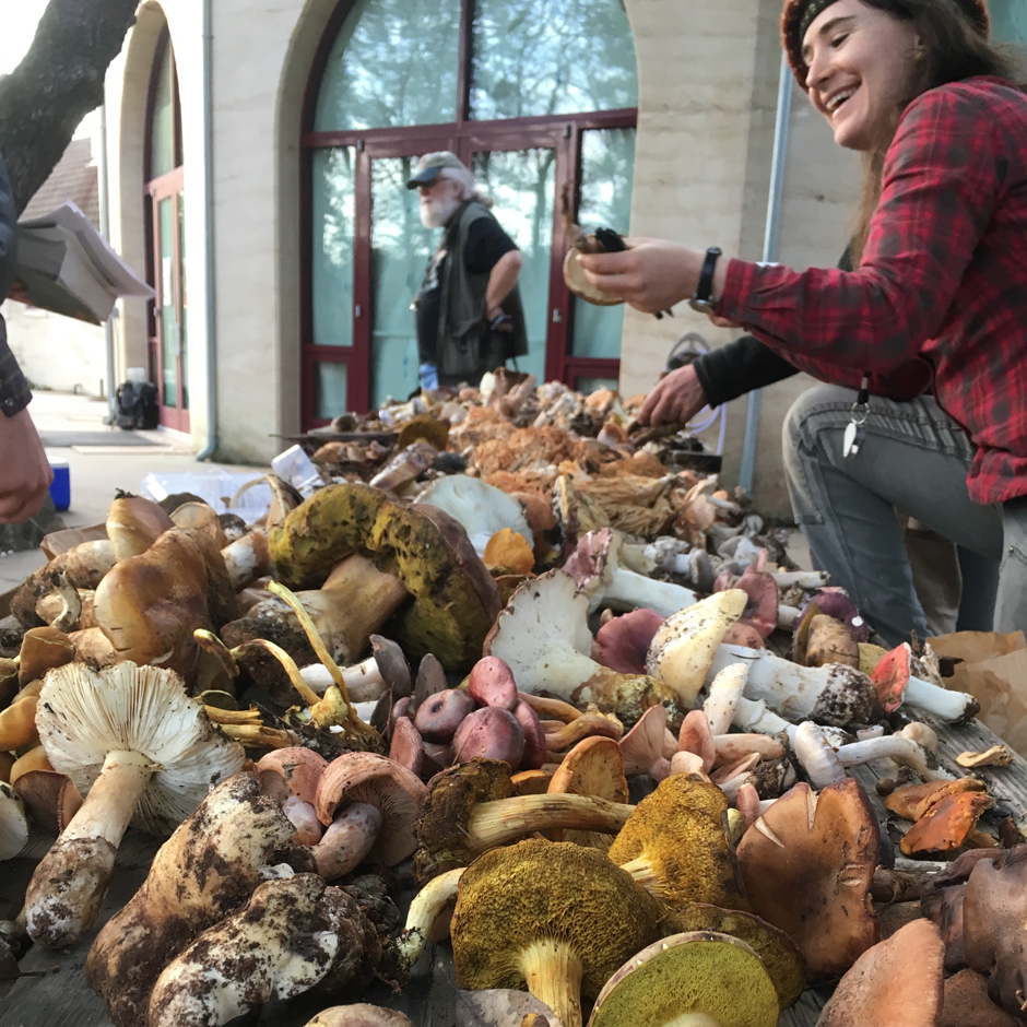
A Yuba Watershed Institute volunteer (Thea Chesney) sorts wild mushrooms at the annual Yuba Watershed Fungus Foray and Wild Mushroom Exposition. (Credit: Chris Friedel)


0 comments