Groundwater Monitoring And More During Heiser Spring Restoration
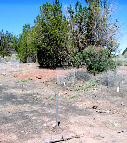
Heiser springbox area, after demolition and revegetation work, August 2010. (Credit: National Park Service)
Between 2006 and 2010, resource specialists with the National Park Service completed work restoring the Heiser Spring area near Wupatki, Arizona. Historically, the spring is just one of three that flow into the Wupatki National Monument.
The spring is fed by a local perched aquifer, which wasn’t contributing much water during the effort because of long-term drought in the region going back to 1996. But bringing back the stream wasn’t the main goal of the restoration work; instead, it was to remove some of the impacts made by an old park service outpost. Before the land was used for that purpose, it served many others, which made the project difficult for managers at times.
According to a media posting by the park service, resource specialists say that the Heiser area was utilized by hunter / gatherers about 6,000 years ago. After that, the region was likely inhabited by Sinaqua farmers around the 1300s and then Navajo sheepherders in the 1860s. Ranchers took over not long thereafter, followed by the park service which turned it into an operations area in the 1950s.
To get around all those cultural issues, National Park Service staff did a cultural resource inventory to locate important archaeological sites nearby and other areas to avoid. Much of the outpost’s infrastructure had been removed through the 1980s, but the spring boxes still remained. These were demolished and removed from the spring site so that natural revegetation and wildlife utilization could begin.

Old Heiser north access road, one year after brushing treatment, August 2010. (Credit: National Park Service)
Efforts that followed included the removal of invasive camelthorn, an aggressive weed that can quickly outcompete native plants, as well as the planting of native shrubs and bushes. Park managers also tracked groundwater levels in the area using a network of piezometers and water level loggers. Data from several loggers were gathered by data loggers over the course of monitoring, but information from most others were gathered manually every month.
The level loggers revealed that the aquifer had fallen to its lowest level on record, including a harsh drought time in the 1950s. Managers blamed recent drought conditions for the low water levels, recognizing that there was little that could be done to maintain the spring while dry conditions persisted.
Nowadays, the number of piezometers in the area has been reduced to just two while resource managers keep an eye on how the restored area is doing. Along with tracking its groundwater, resource managers are also tending to native plants to help them establish and continuing to keep an eye on invasive camelthorn. Efforts to control erosion and expand the ranges of native plants are also being made.
For more complete information on all the work done to restore the Heiser Spring area, see this post from the National Park Service.
Top image: Heiser springbox area, after demolition and revegetation work, August 2010. (Credit: National Park Service)


0 comments