Low Clarity Levels, But No Lack of Progress, for Lake Tahoe
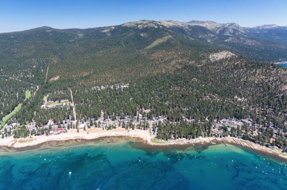
The shore of Lake Tahoe. (Credit: TRPA, Via communication from source)
2017 was a strange year for Lake Tahoe, especially for participants in the Lake Tahoe Environmental Improvement Program (EIP). That’s because the worst drought in hundreds of years was then interrupted by record-breaking precipitation, all leading up to warm lake temperatures and the lowest average clarity levels for the year ever recorded at Lake Tahoe. However, the bigger picture is more complex and looks fairly bright—and hopefully clear—for Lake Tahoe.
The right conditions for a drop in clarity
Thomas Lotshaw, of the Tahoe Regional Planning Agency (TRPA), describes a lake that exhibits unusual clarity to start with.
“Lake Tahoe is one of the largest, clearest, deepest mountain lakes in the world. It’s fairly unique in that the watershed is about 500 square miles or so, and the lake takes up a large portion of that. We have some pretty porous soils up here, so the lake’s clarity is kind of a natural function of it being an ultraoligotrophic lake. A lot of the water that falls in the limited basin gets absorbed into the soil and then filters down into the lake through the groundwater.”
Changing times changed the lake, however, and demand for lumber for the Comstock mines triggered extensive logging in the Tahoe area in the 1860s. About two-thirds of the basin was clear-cut and cattle grazing in the area degraded the land. Those two forces combined with stream channelization to create environmental issues.
“The biggest contributor to clarity declines is sediment getting into the lake, whether that’s from streams impacted by channelization, or roads in urban areas,” adds Lotshaw.
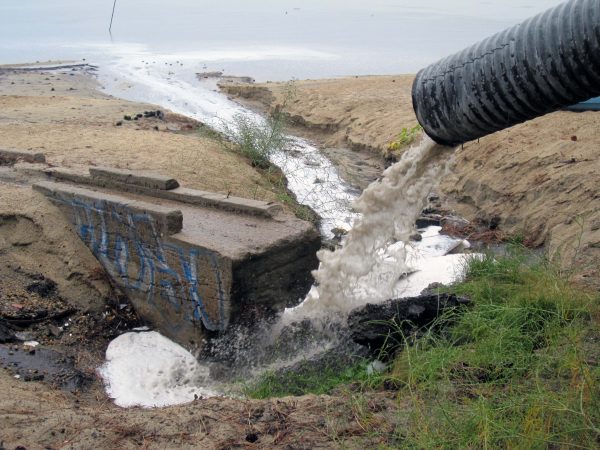
Storm drain pipe transporting fine sediment from the roads into the Lake Tahoe. However, this storm drain was removed while El Dorado Beach was under construction, Summer of 2012. (Credit: By Tahoepipeclub [CC BY-SA 3.0 (https://creativecommons.org/licenses/by-sa/3.0)], from Wikimedia Commons.)
“Back in 1969 or so, California and Nevada saw that runaway development—there was essentially a city the size of San Francisco being pitched up here in the Tahoe basin—so the two states created the Tahoe Regional Planning Agency (TRPA) to better manage that growth, and to work to conserve and restore the environment,” explains Lotshaw. “We have data on clarity going back to 1968 thanks to UC Davis, and much of the work we have been doing here for so long is really focused on reducing stormwater pollution, restoring those natural areas, upgrading the built environment, and getting the development out of those sensitive outlying areas and into town centers where you can create more walkable, bikeable communities—that kind of thing.”
One project at a time
In 1997, Lake Tahoe’s clarity hit the previous record low: 64.1 feet. President Bill Clinton and Vice President Al Gore came to Lake Tahoe at the request of Harry Reid for a multiple-day Lake Tahoe summit focused on the environmental issues facing the lake. The emphasis was on how local, state and federal partners all needed to work together to address the environmental problems in a coordinated fashion. From that summit, the EIP, which is essentially a local-state-federal-private sector partnership, as well as a capital investment program for environmental restoration projects focused on water quality, was born.
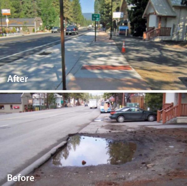
Before and after: Before improvements, a lack of drainage led to loss of clarity, but after improvements, drainage keeps fine sediment from reducing clarity. (Credit: TRPA, Via communication from source)
“Over the last two decades, we’ve done a number of projects with all 50+ of our partners up here,” details Lotshaw. “There’s been major stream restoration work, meadow restoration, wetland restoration, fuel reduction, forest thinning, those kinds of things.”
Among the most successful initiatives has been the total maximum daily load (TMDL) program, a partnership between California and Nevada.
“Lake Tahoe is an amazing natural resource, a beautiful, clear blue lake,” Lotshaw describes. “But it is considered impaired because of the amount of clarity that it’s lost. The TMDL program mapped out the entire watershed and asked: what’s causing these clarity declines? What are the main pollutants of concern? Where are they coming from, and how can we reduce them to a level that allows us to restore the lake’s clarity back to the historic 97 feet by the target date, 2076. So it’s a very long-term initiative, and through it essentially every jurisdiction here at Tahoe has to reduce its pollutant loads.”
The TMDL found that fine sediment particles are the biggest contributor to the clarity loss.
“Those can come from upland areas in some of those degraded streams and then they can also come from roads in urban areas,” remarks Lotshaw. “A large portion of them come from those roads in urban areas where these sediments are essentially ground up into ultrafine particles, and then when those get into the lake are so light and small that they have the tendency to remain suspended in the water column or they refract the light and reduce the clarity.”
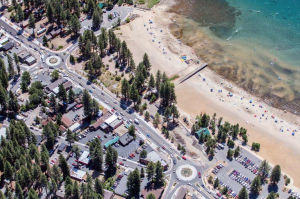
King’s Beach, Lake Tahoe, road reduced to two lanes, roundabouts added, all to reduce fine sediment in lake and improve clarity. (Credit: TRPA, Via communication from source.)
All of the jurisdictions in those first five program years reduced the amount of fine sediment pollution reaching the lake by 268 thousand five hundred pounds. That’s been done by upgrading roads, and by putting in curbs, gutters, drainage inlets, and infiltration basins.
“Essentially every major project that we’ve done here now for a number of years has had some stormwater reduction component to it, to really either clean up the stormwater or to infiltrate it into the ground and keep that fine sediment pollution out of the lake,” states Lotshaw. “So the first five years of the TMDL, everybody met all of the targets, and the initial clarity restoration target was a five year annual average of 73 feet back in 2016.”
Extreme conditions, new records
Of course with extreme conditions, come severe challenges, and 2017 was a year for both.
“Essentially, leading up to 2017, we had five years of the most extreme drought in twelve hundred years or so,” remarks Lotshaw. “During that time, large amounts of sediment were able to accumulate in streams around the basin.”
63 tributaries flow into Lake Tahoe, and only one flows out; the Truckee River. “The drought ended with a big bang, with one of the wettest winters on record, where we saw dozens of those atmospheric rivers converging on California, bringing very large amounts of precipitation and flushing those large sediment loads out of the streams and into the lake reducing the clarity,” adds Lotshaw.
The result was an average annual clarity level for 2017 of 59.7 feet, a drop of about 9.5 feet from 2016. Typically, the clarity would then improve during the autumn months as the lake cooled and the surface waters sank down, but summer was too hot for this natural autumn process to happen. Because the surface waters where sediment was suspended stayed warmer in the fall, they remained toward the top of the lake reducing the clarity throughout the season and dropping the annual average to a record low.
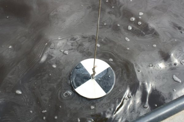
A Secchi Disk suspended at the water’s edge on Cochiti Lake, July 29, 2011. (Credit: US Army Corps of Engineers, https://www.flickr.com/photos/usacehq/6005616136)
“We’re in that weird area where neither the winter nor the summer average is the lowest on record, but the year as a whole is, and I think that was largely because the clarity did not improve as usual during those fall months,” states Lotshaw.
However, this bit of bad news shouldn’t discourage everyone working to keep Lake Tahoe clean.
“Last year came and knocked the five-year average down, but it’s still 70 feet,” Lotshaw points out. “For a long time we were losing clarity regularly every year, but those long-running declines seem to have been stabilized. Last year’s record low number was not entirely unexpected. I don’t know if anybody was expecting it to drop down to a new record low, but we were all certainly anticipating a low clarity year just based on those drought conditions and followed by the winter that we had up here.”
Nevertheless, the local programs are steadily making progress on the long-term issues that hurt the lake’s clarity.
“We have a requirement that all properties in the Tahoe Basin have best management practices to essentially retain their stormwater onsite and infiltrate it into the ground and prevent erosion,” states Lotshaw. “So we’re making steady progress on working with homeowners and business owners, especially of the highest priority properties, the commercial and multifamily properties, have best management practices in place to reduce stormwater pollution into the lake.”
Lotshaw cites the Bijoux Erosion Control Project in the city of South Lake Tahoe as an example. Completed a couple of years ago, this was an area-wide approach to capturing and treating stormwater.
“The Bijoux commercial core is heavily developed and had a large amount of stormwater problems,” explains Lotshaw. “There’s now a large amount of infrastructure under a 42-acre area of the Bijoux commercial core that’s capturing the stormwater in an area that had some of the highest pollutant loads in the Lake Tahoe basin. The infrastructure captures the stormwater and pumps it uphill to a large infiltration basin where it can discharge and then be allowed to soak into the ground, filter through the groundwater, and find its way back into the lake. The city has reduced the amount of nitrogen phosphorus and fine sediment washing into the lake from the commercial core by 96 percent—that’s a reduction of more than 20,360 pounds of fine sediment each year.”
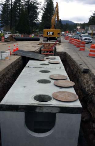
Underground stormwater sedimentation vault being built as part of improvements. (Credit: TRPA, Via communication from source)
Facing the future
Water clarity is typically measured as the depth to which a Secchi disk, a white, 10-inch disk, can still be seen in the water. For obvious reasons, clarity is generally measured mid-lake, and to ensure rigorous results, anyone measuring clarity is consistent in where and how they monitor.
However, Lotshaw and the team are hearing new questions and concerns from local people.
“Over the last five to ten years we’ve heard anecdotally from folks who say the water quality in the nearshore is not as good as it used to be, there’s more algae on the rocks, there’s more algae mats growing in the lake,” details Lotshaw. “So over the last five or ten years there’s also been a push to expand some of the nearshore water quality monitoring, in terms of turbidity, attached algae, how algae attach to rocks, free-floating algae, invasive species, those kinds of things, so now we’re really building out not only the mid-lake water quality data but also ramping up some of the nearshore water quality monitoring as well.”
Various invasive species have been introduced to Lake Tahoe over the years. According to Lotshaw, the species of top concern right now are Eurasian watermilfoil, curly leaf pondweed, and Asian clams, which can release nutrients that cause some algae growth. And even when parsing out possible approaches to new challenges, existing partnerships and data are making progress possible.
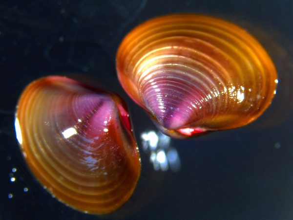
Asian clams. (Credit: By California Department of Fish and Wildlife from Sacramento, CA, USA (Asian clam) [CC BY 2.0 (https://creativecommons.org/licenses/by/2.0)], via Wikimedia Commons)
The science indicates to Lotshaw and other partners that the long-term clarity loss is stabilizing and that these projects are making a difference.
“Continuing the work we’re doing with all of our partners here at Tahoe to reduce stormwater pollution from roads in urban areas and from the built environment, coupled with all of the environmental restoration projects to improve stream health, to restore meadows and wetlands that act as natural filters for the water flowing into the lake, and to improve forest health and reduce fire and erosion risk in the forests, those will remain key strategies going forward,” adds Lotshaw.
The UC Davis team, the TRPA, and other partners in the area are ready for the future.
“It’s going to be an interesting century, but I think we’re in a very good place,” Lotshaw concludes. “We have a lot of people who are committed to the lake’s success and care about it and see it as really an irreplaceable national treasure. We have all the partnerships that have been formed, and everybody’s really committed to working together. When you see a low clarity year that can be frustrating and discouraging, but hopefully everybody will recognize the importance of continuing to work together to protect one of America’s national treasures.”
For results on EIP programs, visit this link: https://eip.laketahoeinfo.org/Results/EipResultsByProgram
Top image: The shore of Lake Tahoe. (Credit: TRPA, Via communication from source)
One Comment
Leave a Reply


Pingback: Water News for September 12, 2018