
NASA IceBridge mission to operate from Antarctica for first time
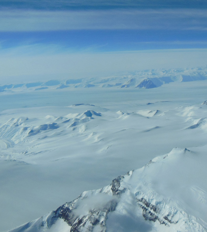
A view of Antarctica’s ice sheet and mountains seen from a U.S. Air National Guard LC-130 aircraft during a flight to the South Pole in December 2012. (Credit: NASA/Christy Hansen)
NASA’s IceBridge mission to measure snow and ice in the Arctic will be based on Antarctica for the first time ever this November.
The IceBridge team of scientists, technicians and instrument operators will base themselves in Antarctica’s McMurdo Station, a U.S. climate research center. The team will fly a data-collecting aircraft across the continent to measure snow, ice and landscape conditions.
Previously, the team operated from Chile, which meant more flight time and less data. “We’re going to collect more science hours of data per flight time,” said Christy Hansen, IceBridge project manager, during an online IceBridge press conference this week. “Previously, when we deployed from Punta Arenas, Chile, we lost a lot of our science data collection time flying over the Drake Passage.”
The U.S. government’s recent shutdown cut the team’s science time anyway. “Our field season has been shortened by about 75 percent,” said Michael Studinger, IceBridge project scientist during the press conference. “So, that means we will collect considerably less science data than we had planned for.”
Despite the shortened field time, the IceBridge team will continue to add measurements to a U.S. data set that would otherwise stagnate.
The IceBridge Mission started when NASA’s Ice, Cloud and land Elevation Satellite, or ICESat, stopped collecting data in 2009. IceBridge continues ICESat’s three dimensional ice data until NASA can get another satellite in orbit.
Researchers collect data in Antarctica with a sensor-laden P-3B Aircraft.
IceBridge scientists and instrument technicians will mainly focus their efforts on collecting Ice thickness, melting rates and landscape characteristics.
")
IceBridge P-3B Aircraft (Credit: NASA)
A laser altimeter will be used to measure ice shelf levels. Radar will measure snow and ice thickness. A gravimeter and magnetometer will measure ice thicker than the range of radar. Several depth sounders will be map topography and ice.
Researchers from the University of Kansas will operate the radar instruments. Columbia University researchers will be working the gravimeter and magnetometer. NASA scientists will operate the laser altimeter.
A total of 40 flights are planned. Hansen said the team will examine the weather daily and determine which flight to take based on research priorities. Time constraints make flying all planned routes impossible.
The researchers plan to head to the South Pole at 88 degrees south where satellites miss ice and landscape data. Other targets include the Ross Sea, Ross Ice Shelf and Transantarctic Mountain Range.
")
View of McMurdo Station from Hut Point. (Credit: NASA/Christy Hansen)
Studinger said the mission is important as there are still many unknowns about sea ice. “The ice streams along the Siple Coast in west Antarctica are changing their ice surface velocity,” he said giving one example. “We know this from satellite measurements from space, but we don’t know how the volume changes (or) the ice surface elevation. And so between 2009 and 2016 we have potentially one data point or maybe not even a single data point.”
Forward-looking research efforts continue to pay off for the team. In August, NASA officials announced IceBridge researchers in Greenland found a massive canyon beneath the nation’s ice sheet.
All data collected by the IceBridge missions in Antarctica and Greenland are available free to anyone six months after collection and processing.
Ice data will be used by climate scientists in to model conditions around the world. It will also be used to calibrate NASA’s next Ice, Cloud and land Evolution Satellite, or ICESat-2.
The IceBridge mission will continue annually until 2017. It’s planned to cease one year after ICESat-2 is in space and operational.
Top image: A view of Antarctica’s ice sheet and mountains seen from a U.S. Air National Guard LC-130 aircraft during a flight to the South Pole in December 2012. (Credit: NASA/Christy Hansen)


0 comments