NASA’s DISCOVER-AQ mission hones satellite tools with aircraft- and ground-based sensors

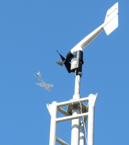
A DISCOVER-AQ ground site operated by Penn State at Porterville, Calif. (Credit: Doug Martins/Penn State)
NASA researchers seeking a profile of pollution near the Earth’s surface have had to get creative to fill in air quality data gaps between measurements on the ground and the Federal Aviation Administration’s minimum flying altitude of 1,000 feet.
“We have begun to use local airfields near ground monitoring sites to reach lower than 1,000 feet,” said Jim Crawford, NASA chemist and principal investigator for the agency’s surface condition air pollution study. “We do this by performing missed approaches on these airports, which is essentially approaching the airport as if we were going to land, but not actually landing the plane.”
Monitoring aerobatics are among many other efforts that are part of the DISCOVER-AQ study, which stands for Deriving Information Surface conditions from Column and Vertically Resolved Observations Relevant to Air Quality. It’s goal is to help satellite instruments differentiate between pollution on the surface and pollution higher in the atmosphere. Those tools can determine the total amount of pollution in an area but can’t tell the difference between what’s high in the atmosphere and what’s down on the ground where people live and breath.
One big focus of the study is finding new ways to compare ground and space-based measurements.
“By collecting atmospheric profiles in the lower atmosphere above ground monitors, while also using satellite-type remote sensors to measure the (air) column abundances, we can learn more about the factors governing the distribution of pollution in the atmospheric column and develop better methods for the interpretation of satellite observations,” Crawford said.

DISCOVER-AQ Principal Investigator James Crawford onboard NASA’s P-3B aircraft (Credit: NASA/Paul E. Alers)
The DISCOVER-AQ team collects data through a range of altitudes, from ground level to 1,000 feet and higher. Some of the aircraft-mounted sensors are similar to spectrometers used in space to measure air pollutants.
Instruments fill the cabins of NASA’s P3B and B200 aircraft, and scientists consider each to be an airborne laboratory. Sensors sample and monitor for aerosols, carbon dioxide, nitrous oxide and other greenhouse gasses. NASA’s B200 plane also carries a pair of remote sensors similar to those carried on satellites.
On the ground, researchers monitor for ozone, nitrous oxide, sulfur dioxide and carbon dioxide among other air pollutants. Five “mobile measurement labs” consisting of three box trucks, one van and one full size car collect data while they travel around study areas.
“This generates a multi-perspective dataset useful to understand the challenges in connecting the satellite and surface views of air quality,” Crawford said.

Aircraft-mounted air quality sensors measure aerosols, carbon dioxide, nitrous oxide and other greenhouse gasses(Credit: James Blair/NASA)
Data collected will be used to calibrate and interpret satellite observation in the new Tropospheric Emissions: Monitoring of Pollution study. A new TEMPO satellite equipped with a pollution measuring spectrometer will launch in 2018. It and a constellation of satellites will monitor pollution and greenhouse gasses over North America from Mexico City to the Canadian Tar Sands in Alberta, Canada.
Estimating airborne emissions near Earth’s surface at a fine resolution is difficult as there are many variables which can impact readings. Ozone pollution, for instance, is challenging to quantify from space due to a heavy ozone presence in the stratosphere.
Satellites also measure fine particles in the air through a different method than researchers do on the ground. Spectrometers on satellites measure the optical backscatter of particulates while ground based instruments measure the mass of pollutants. Finding a mathematical relationship between the two is another hurdle that researchers will have to jump as they work in DISCOVER-AQ.
Researchers from NASA, University California Berkley, University of Colorado Boulder, University of Innsbruck, Millersville University and Penn State have all contributed to the study.
DISCOVER-AQ was funded in 2010 and monitoring began in the Washington, Baltimore, California’s San Joaquin Valley and Houston. The last DISCOVER-AQ study is planned for Denver in the summer of 2014.
Image: A DISCOVER-AQ ground site operated by Penn State at Porterville, Calif. (Credit: Doug Martins/Penn State)


omer
November 12, 2014 at 3:42 pm
Dear
I am a student of Master at Gaziantep university my subject is about Air Pollution at Duhok city/Kurdistan/Iraq.
I need your advice for choosing of mobile measuring device for air pollution fixed with the car.
Best Regards
Omer