New Lake Michigan Buoy To Provide Nearshore Info To Beachgoers, Scientists
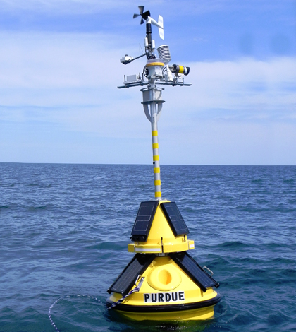
Purdue University and Illinois-Indiana Sea Grant deployed this environmental-sensing buoy in the Lake Michigan nearshore to provide information such as wind speed, air and water temperature, and wave height and direction for boaters and beachgoers. (Credit: Irene Miles / Illinois-Indiana Sea Grant)
For some time, the only monitoring platforms near Chicago that weren’t far offshore or sitting behind break walls sat near Milwaukee or Michigan City, Indiana. That meant that information on nearshore conditions and wave action were lacking. A new data buoy launched by the Illinois-Indiana Sea Grant and LimnoTech has changed that.
The S2 Yachts TIDAS 900 buoy has been deployed in Lake Michigan near the city of Wilmette, Illinois, and is providing valuable weather and water quality data to those living and playing in the area as well as those performing research around the Great Lakes.
A group of paddlers near Chicago first approached the Sea Grant about putting the buoy in, but it was not until a grant opportunity through the Great Lakes Observing System and the Coastal Storms Program came up that filling the need was possible. From there, the Sea Grant worked with LimnoTech, an environmental consultancy based in Ann Arbor, Michigan, to get the buoy in the water.
Wilmette is a little north of Chicago, but the location is ideal given all the fishing and boating that goes on closer to the Windy City.
“When we were trying to place the buoy, Jay Beugly (aquatic ecology specialist at the Sea Grant) was at the Chicago Boat Show talking to anglers,” said Carolyn Foley, assistant research coordinator for the Sea Grant. “People there told him that where we had it, it was going to get run over. So we decided to move it.”
That sort of flexibility goes along with the larger goal of the new buoy, which is to serve as many different groups who need the data as possible. Some of the sensors gathering the useful nearshore information cover weather parameters like solar radiation, air temperature, atmospheric pressure, relative humidity, and wind speed and direction. Other sensors in Lake Michigan itself record measurements of water temperature near the surface and data on wave height, period and direction.
The data are posted online at various locations to reach those living near and far. The Great Lakes Observing System posts the data to its website and so does the National Data Buoy Center. Both of these make it possible for researchers around the Great Lakes basin, or worldwide, to check on nearshore conditions to integrate in studies and modeling work they’re doing.
Foley says that a group of researchers from the U.S. Geological Survey are using the buoy’s data for E. Coli modeling. Wind direction is incredibly important for the accuracy of their work, so the buoy is really helpful for them. Forecasters at the National Weather Service, she says, were also glad to have the buoy’s data coming in after one of their buoys went out of service. The NWS needs to know real-time conditions to issue informed advisories to keep people safe.
For people near Chicago, the Sea Grant posts the Wilmette buoy’s measurements on its website. There is an added benefit to those checking the data there: A webcam, funded solely by the Sea Grant, captures video of real-time wave action on the lake.
“We really wanted to put a webcam on it because it helps to actually see what conditions are on the water in addition to knowing the wave height,” said Foley. “The Sea Grant added the webcam because it’s helpful.”
Foley says that tourists calling in to the Sea Grant have told officials there that they rely on the webcam to let them know if it’s worth making the long drive to Lake Michigan. In the future, she would also like to see the webcam’s footage used in television weather forecasts that could utilize it in background shots.
All of the data and webcam footage are valuable, Foley says, and she hesitates to pick any one parameter as most important. In all actuality, it probably depends on the person using the information.
“We hope people find it useful. If they have any suggestions, for the Sea Grant site especially, we want people to give us feedback,” said Foley. “If there are particular sensors they’re interested in, we’ll see what we can do. We’ve heard from some anglers who want temperature chains. So we like to hear suggestions.”
Top image: Purdue University and Illinois-Indiana Sea Grant deployed this environmental-sensing buoy in the Lake Michigan nearshore to provide information such as wind speed, air and water temperature, and wave height and direction for boaters and beachgoers. (Credit: Irene Miles / Illinois-Indiana Sea Grant)


0 comments