NOAA Alaska buoy network to monitor North Pacific ocean acidification
National Oceanic and Atmospheric Administration scientists detected signs of ocean acidification in the waters that hold the vulnerable and valuable fisheries of the North Pacific off the coast of Alaska, but they only had a snapshot of the action.
“We know that in this place were important commercial and subsistence fisheries that could be at risk from ocean acidification,” said Jeremy Mathis, a NOAA Pacific Marine Environmental Laboratory researcher and professor at the University of Alaska Fairbanks.
To understand how ocean acidification affects the North Pacific, NOAA scientists created a mooring network that collects constant in situ data on parameters contributing to acidification. They hope it will reveal seasonal trends and patterns left out by their snapshots. The monitoring buoys will also act as an alert system for threatening pH levels, which have potential to degrade the vitality and diversity of Alaska’s fisheries.
In the North Pacific, upwelling brings thousand-year-old water, which just crossed the world, to the surface. The water is high in carbon dioxide and low in aragonite and calcite, the two bicarbonates from which shellfish build their exteriors.
Ocean acidification, resulting from increasing carbon dioxide in the ocean, lowers pH and carbonate even more. Mathis said that can have economic impacts on everyone in country.
At the dock, Alaskan-caught North Pacific fish bring about $1.5 billion to fishermen each year, according to the Alaska Department of Fish and Game. Alaska’s fisheries also fuel 78,500 Alaskan jobs.
About 8 percent of fish caught are shellfish, which are the hardest hit by acidification. NOAA’s new buoy network will provide real time data to scientists and fishermen through the Alaska Ocean Observing Systems Cook Inlet Response Tool so that they can learn and react to pH conditions.
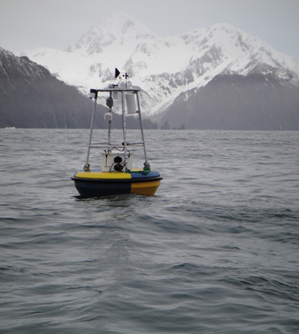
So far, NOAA techs and scientists have installed two monitoring buoys. One is off the southeast coast of Alaska near Port Conclusion and the second is in the northern Gulf of Alaska near Seward. “The next three will go close to Kodiak Island, in the Bering Sea west of Bristol Bay and the Arctic-Beaufort Sea east of Point Barrow,” Mathis said.
Each mooring in the monitoring network has two sensor packages. The first is suspended one meter beneath the water’s surface. The second sits on the ocean floor, which ranges from 30 meters deep to 275 meters deep.
Sensors track pH, carbon dioxide, chlorophyll, nitrate, oxygen and temperature. Sensors from Battelle and Sunburst track pH and carbon dioxide levels. Seabird instruments handle the other parameters.
The sensor package at the ocean’s surface broadcasts data every three hours via satellite telemetry. The package on the ocean floor collects real-time data and stores it in a data logger. Mathis said NOAA techs and scientists retrieve the data every six months.
Given Alaska’s rugged terrain and harsh weather, visiting the remote mooring may not always happen on schedule. Mathis said weather is the greatest limiting factor hindering deployment or data retrieval. The Bearing Sea is especially unforgiving. “We have twice a year. That’s our only opportunity to get out there and do anything,” Mathis said. And there are no guarantees that things will go smoothly even during those ideal times.
Seawater also makes maintaining accuracy a chore for the Alaska monitoring team. Mathis said the team takes discrete samples seasonally to double-check the sensor readings. They also pull sensor packages every six months to a year to have them serviced and calibrated.
The biggest challenge to maintain calibration, Mathis said, is biofouling. He described a monitoring package recently pulled by one of his technicians. “It looks like a botanical garden,” he said. “…It’s just a big stable platform that stuff can grow and stick to.”
In a presentation at the Alaska Marine Science Symposium in January, Mathis explained the gravity of ocean acidification trends and their long-term impact. “We’re obviously going to lose the oysters and the clams if we keep going on these trajectories,” he said.
Mathis continued by quoting Beth Fulton, a scientist at Australia’s Commonwealth Scientific and Industrial Research Organisation specializing in marine ecosystem modelling. “We will still have fisheries, if we’re willing to eat different fish.”
Click here to for a full length podcast of Mathis’ presentation, which includes good explanations of ocean acidification, history of past acidification events and the new buoy network.
Top image: A buoy near Seward Ala. in the Alaska pH monitoring network spurred by ocean acidification (Credit: Jeremy Mathis)


0 comments