Puget Sound sediment study looks to fill degraded inlet’s data gap
Sediment in Washington State’s Puget Sound is growing more polluted, and scientists aren’t entirely sure why. Water quality specialists from the U.S. Geological Survey aim to change that.
The Washington State Department of Ecology recently reported that some aspects sediment health in the sound have gotten worse over the last decade. Poor sediment quality has adversely impacted macroinvertebrates and water quality. A new USGS study is tracing Puget Sound sediment upstream to its tributary rivers to evaluate sediment volumes and quality.
“One area that we know where there is a known gap in our understanding is in the type and levels of contaminants that are transported from large rivers to the Puget Sound,” said Kathy Conn, a USGS water quality specialist working on the study.
The USGS uses a combination of monitoring and precise sampling to obtain sediment samples during times of high sediment loading. Sampling sediment may sound like a simple task, but obtaining a representative sample of a river’s sediment loading takes some calculation and planning.
Stream gauges and real-time turbidity monitoring help Conn choose sampling days. She tries to sample when sediment is highly suspended in rivers. “We are trying to strategically sample at high turbidity events with the hypothesis that these high turbidity events carry more loads of contaminants than a baseline flow,” she said.
Conn uses a special sampling process takes a representative sample of an entire cross section of a river. She and her colleagues sample from bridges above the rivers to gain access to the entire surface. They sample based on tested USGS protocols to ensure standardized methods to gain a representative sample of the river.
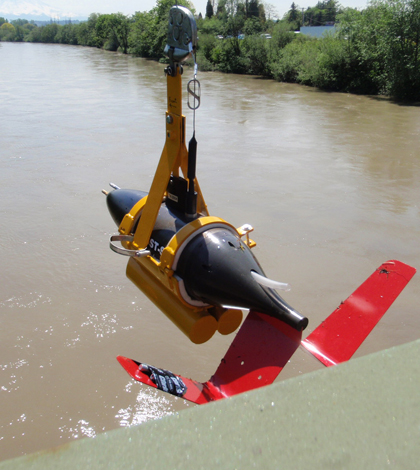
The researchers also analyze suspended sediment particles with Laser In-Situ Scattering and Transmissometer. That information is paired with acoustic Doppler current profilers, which give water velocity data.
Conn said she often sees distinct sediment signals depending on the season and likely cause of the sediment loading.
The Puyallup River, for instance, is glacier-fed and runs down Mt. Rainier. Conn said sediment from ice and snow melt often brings fine glacial flour into the river. Sediment loading from heavy rains is much more varied, on the other hand.
Once researchers collect a few thousand liters of water for their cross section samples, they take it back to their lab and sort the water from the sediment.
Conn is attempting a new method for filtering that large volume of water. She has a special flow-through centrifuge that deposits sediment into a bowl as water continually passes through.
")
Conn’s flow-through centrifuge setup includes a Geotech Geopump (Credit: USGS)
She said the unique approach gives her flexibility in sediment extraction. “We’re using it to concentrate suspended sediment that may be 100 milligrams per liter or even 10 milligrams per liter in water,” she said.
Once water passes through the centrifuge, a slurry of sediment is left behind that Conn can send to a lab for testing.
Laboratory analysis focuses mainly on legacy compounds, like polycyclic aromatic hydrocarbons, and newly emerging contaminants, such as pharmaceuticals.
Conn said the centrifugal method was the best way she could find to extract sediment from large volumes of water. Filters would not work well, as they can get clogged or too full. Removing sediment from the filters for analysis is also difficult.
“There’s no easy way to sample suspended sediment,” she said. “That’s why there’s a data gap.”
Top image: A Laser In-Situ Scattering and Transmissometer ready for deployment on a Puget Sound tributary as part of the USGS sediment survey (Credit: USGS)


0 comments