
Saltwater Intrusion, Elevation Data Gathered For Georgia Sea Rise Modeling
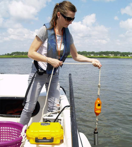
Researcher LeeAnn DeLeo lowers a YSI Castaway CTD (conductivity, temperature, depth) sensor to measure in a profile. (Credit: Skidaway Institute of Oceanography, U. Georgia)
Georgia has about 30 percent of all the existing salt marsh on the United States’ eastern seaboard. Much of that is expected to migrate inward with predicted sea level rise in the future, possibly impacting plant and animal habitats and commercial fisheries.
Understandably, scientists have many questions for what these moving marshes could bring about. A few at the University of Georgia’s Skidaway Institute of Oceanography and Georgia Southern University have embarked on a study to model what the state’s coasts will look like within the next 100 years.
Scientists are focusing their efforts on five coastal river systems: the Savannah, Ogeechee, Altamaha, Satilla and St. Marys. Work has been completed to gauge saltwater intrusion on three of those. Two more are expected to be surveyed by early September. After data collection is finished, all of the measurements will be plugged into the Sea Level Affecting Marshes Model (SLAMM) developed by the National Oceanic and Atmospheric Administration. This will allow scientists to accurately predict the impacts that sea level rise could have on the area.
“There are a number of saltwater marshes along the coast that don’t have a river at their head,” said Clark Alexander, professor at the Skidaway Institute. He is working with Christine Hladik, an assistant professor of geology and geography at Georgia Southern University to complete the work. “These are more influenced by saltwater intrusion than a river.”

Researcher Mike Robinson prepares the salinity monitoring system for operation, while fellow researcher LeeAnn DeLeo drives the boat. (Credit: Skidaway Institute of Oceanography, U. Georgia)
It is along these waterways that scientists sample in a boat, starting from their mouths about an hour before high tide and then continuing along while taking measurements all the way to the spot where saltwater intrusion ends, usually a distance of about 35 to 40 kilometers. A lot of this work relies on a Seabird CTD (conductivity, temperature, depth) sensor deployed in a flow-through chamber on the side of the boat that scientists pump water through as they move along their sampling route.
Researchers are also using a YSI Castaway CTD that gets lowered off the side of the boat to capture measurements in a profile. Since the device has integrated GPS, researchers can know exactly where each point was taken.
“It gives us a good representation of what is throughout the water column,” said Alexander. “In general, we have a lot of tidal elements in our system. It’s a 3-meter tidal range. Water quality is pretty well mixed.”
Taking data from the two CTDs together, researchers are populating a highly accurate set of measurements on saltwater intrusion in the five coastal river systems. But those are not the only pieces of the puzzle. To complement those measurements, Hladik is working with LIDAR (Light Detection And Ranging) data to gauge what sort of effects elevations in the marshes could play.
But there’s an issue with those measurements, as some of the vegetation in the study area is too dense for LIDAR to cut through.

Researcher LeeAnn DeLeo monitors the flow of data while the ship is underway. (Credit: Skidaway Institute of Oceanography, U. Georgia)
“The marsh grass is so dense that the laser pulses don’t make it to the ground,” said Alexander. “So we’re having to develop correction factors for LIDAR based on vegetation type.”
Some of the grasses are tall and dense, he says, while others are short and thin. So Hladik goes to different areas within the marshes with a Trimble R6 GPS unit and compares LIDAR measurements to Real Time Kinematic GPS data. In layman terms, this means they compare elevation data taken with LIDAR to elevation data Hladik collects on the ground.
“For example, if the LIDAR measurement is too high, we can figure out how much we need to subtract,” said Alexander. “We want to do it so that the elevations of the marsh are accurate because if you want to know when the marsh is going to be flooded by tides, you need good elevation data.”
Alexander says the team has collected about 500 data points so far. The hopes are that those and others to be collected will result in a SLAMM simulation for the region that can predict what rising sea levels could do there within the next 100 years.
From there, the model could play a big role in preparing the region for possible sea level rises in the future.
“We’re hoping that, as we get a better idea of where marshes migrate over time, there will be a concerted effort to maintain them,” said Alexander. “Armoring of the coastal zone could help keep them from migrating inland. If we can identify where movement is possible in the future, we can also maintain areas where future marshes might migrate. The model could also be used for better storm inundation preparedness.”
Top image: Researcher LeeAnn DeLeo lowers a YSI Castaway CTD (conductivity, temperature, depth) sensor to measure in a profile. (Credit: Skidaway Institute of Oceanography, U. Georgia)


0 comments