
San Joaquin Valley Sinks At Record Pace Due To Groundwater Pumping
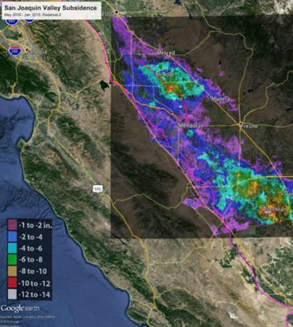
Total subsidence in California's San Joaquin Valley from May 3, 2014 to January 22, 2015. (Credit: Canadian Space Agency / NASA / JPL-Caltech)
An unusually high amount of groundwater being pumped out of California’s San Joaquin Valley is leading to record-breaking sinkage of land there, according to a release from NASA’s Jet Propulsion Laboratory. The ongoing drought in California is to blame, requiring extremely high levels of groundwater to make up for the lack of rainfall and adequate snow melt. More groundwater pumping means more land sinkage, which could potentially cause harm to infrastructure.
Images reviewed by NASA scientists using interferometric synthetic aperture radar (InSAR) observations from satellites and aircraft as well as Uninhabited Aerial Vehicle Synthetic Aperture Radar (UAVSAR) show that the sinking of the Earth, also called subsidence, has become unusually rapid, with some areas subsiding by as much as 13 inches in eight months. The InSAR method is said to be approximately accurate to the centimeter.
The sinking has become especially important for structures such as the California Aqueduct, which has sunk 12.5 inches in places. The Aqueduct carries water from the Sierra Nevada mountains as well as Central and Northern California and brings it to Southern California.
Top image: Total subsidence in California’s San Joaquin Valley from May 3, 2014 to January 22, 2015. (Credit: Canadian Space Agency / NASA / JPL-Caltech)


0 comments