With Twisp River Stream Restoration Finished, Foundation Tracks Wetland Impacts
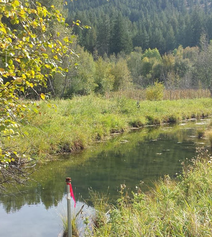
A monitoring well in a dredged portion of a wetland along Twisp River in Washington state. (Credit: Brian Fisher / Methow Salmon Recovery Foundation)
For several decades, a wetland along the Twisp River in north-central Washington has been used as a re-regulating irrigation reservoir by a landowner looking to support their crops.
“Water was diverted from a small stream into the wetland, then pumped out of the wetland to irrigate about 35 acres of hay and pasture,” said Brian Fisher, ecologist and project manager at the Methow Salmon Recovery Foundation. “The irrigation system was diverting the majority of the stream during low flows, and was creating barriers that blocked fish migration for part of the year.”
Fisher and others at the foundation worked with the landowner to change things up and use water from a well instead of continuing to divert surface water. That helped to make irrigation more efficient and left more water for salmon, but there was another key concern: What effects could the switch have on surrounding habitat?
“While it was clear from the outset that this would improve fish passage and habitat conditions in the stream, we also needed to understand how it would affect the wetland,” said Fisher.
To shed some light on those impacts, he and a field technician set up a network of piezometers (shallow groundwater monitoring wells) using Heron dipperLog NANO water level and barLog NANO barometric pressure loggers. The loggers were chosen because of their low price point, Fisher says, coming in several hundred dollars less than competing devices.
Setting up the network was relatively straightforward, but there were a few hiccups toward the beginning of data collection.
“Unfortunately, almost all (8 out of 10) of the loggers failed within the first year, with many of the failures causing data gaps,” said Fisher. “The company (Heron) was very good about replacing the defective loggers and when it was apparent that there was a major issue, replaced all of the loggers with a newer model.”
After resolving those issues, the network has yielded reliable data that have illuminated some important dynamics of the surrounding wetland.
“The water level data allowed us to identify three separate water sources for this wetland, and be confident that the project wouldn’t trade off (one) type of habitat at the expense of another,” said Fisher. “The water level data in this wetland showed that the water level in the majority of the wetland was above the irrigation inlet; consequently, we could be confident that we wouldn’t dry up the wetland by the irrigation well conversion.”
The data have also shown Fisher and others at the foundation what might happen at associated wetlands if abandoned irrigation diversions and rock levees were removed. And there was a small surprise, too.
“We were surprised by the amount of groundwater that was flowing through the wetland during dry-low flow periods,” said Fisher.
The monitoring network was established while planning and developing a stream and wetland restoration project in partnership with the U.S. Bureau of Reclamation, Bonneville Power Administration, the Upper Columbia Salmon Recovery Board and InterFluve, Inc.
Top image: A monitoring well in a dredged portion of a wetland along Twisp River in Washington state. (Credit: Brian Fisher / Methow Salmon Recovery Foundation)


0 comments