
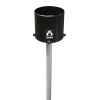
HOBO Data Logging Rain Gauge
Features
- Time and date stamp is stored for each tip for determining rainfall rates and duration
- Compatible with HOBOware and HOBOware Pro software for logger setup, graphing and analysis
- Also records temperature when used with an optional solar radiation shield
- Free ground shipping
- Expedited repair and warranty service
- Lifetime technical support
- More
Overview
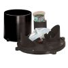
Record up to 160 in. of rainfall at rates up to 12.7 cm (5 in.) per hour. The Data Logging Rain Gauge system is battery-powered and includes a HOBO Pendant Event data logger with a tipping-bucket rain gauge. Easily collect rainfall, time, and duration data, as well as temperature, when used with an optional solar radiation shield (RS1 Solar Radiation Shield, or M-RSA). A base station or shuttle is required.
Rain Gauge
Maximum rainfall rate: 12.7 cm (5 in.) per hour
Calibration accuracy: ±1.0% (up to 1 in./hour for the RG3 or 20 mm/hour for the RG3-M)
Resolution: 0.01 in. (RG3) or 0.2 mm (RG3-M)
Calibration: Requires annual calibration: can be field calibrated or returned to the factory for re-calibration
Operating temperature range: 0° to +50°C (+32° to +122°F)
Storage temperature range: -20° to +70°C (-4° to +158°F)
Environmental rating: Weatherproof
Housing: 15.24cm (6-in.) aluminum bucket
Tipping bucket mechanism: Stainless steel shaft with brass bearings
Dimensions: 25.72 cm height x 15.24 cm diameter (10.125 x 6 in.); 15.39 cm (6.06 in.) receiving orifice
Weight: 1.2 Kg (2.5 lbs)
Part numbers: RG3 (0.01 in. per tip) ; RG3-M (0.2 mm per tip)
Logger
Time stamp: Resolution 1.0 second
Time accuracy: ± 1 minute per month at 25°C (77°F), see Plot B on page 10.
Operating range: -20° to 70°C (-4° to 158°F)
Environmental rating (for logger used outside of rain gauge): Tested to NEMA 6 and IP67; suitable for deployment outdoors
NIST traceable certification: Available for temperature only at additional charge; temperature range -20° to 70°C (-4° to 158°F)
Battery: CR-2032 3V lithium battery; 1 year typical use
Memory: 64K bytes – 16K to 23K tips when recording rain only; 25K to 30K data points when recording rain and temperature
Materials: Polypropylene case; stainless steel screws; Buna-N o-ring; PVC cable insulation
Temperature Measurement
Measurement range: -20° to 70°C (-4° to 158°F)
Accuracy: ± 0.47°C at 25°C (± 0.85°F at 77°F). A solar radiation shield is required for accurate temperature measurements in sunlight.
Resolution: 0.10°C at 25°C (0.18°F at 77°F), see Plot A on page 10.
Drift: Less than 0.1°C/year (0.2°F/year)
Response time: Airflow of 1 m/s (2.2 mph): 10 minutes, typical to 90%
- Tipping-bucket rainfall collector
- HOBO Pendant Event Logger
- Mounting accessories: two hose clamps, three screws
Select Options


In The News

Wildfire Prevention in the Sierra Nevada Region with the Yuba Watershed Institute
Though recent wildfires have sparked new conversations about wildfire management and response, groups like the Yuba Watershed Institute have been monitoring the forests and water resources of the Sierra Nevada region for decades, managing approximately 5,000 acres of land with the Bureau of Land Management (BLM) and about 7,000 acres in private land partnerships. The goal of the Institute is to work with local communities and land agencies to improve watershed and forestry management through informed practices and public outreach. The goals of the Yuba Watershed Institute are three-fold: Improve the ability of fire suppression agencies like the California Department of Forestry and Fire Protection ( CAL FIRE ) and the US Forest Service.
Read More
Wave Sensors Integration with NexSens Buoys: A Cutting-Edge Solution for Wave Measurment
Real-time wave data supports accurate weather prediction, safe and efficient maritime operations, and provides valuable safety and operating condition information for recreation and commercial fishing. Understanding wave dynamics also helps with the design of protective coastal structures like seawalls, breakwaters, and jetties. It also supports better prediction of their impact on sediment transport and coastal geomorphology. Wave data is a key factor in qualifying and designing offshore wind farms and harnessing kinetic energy for electrical generation. It helps with the understanding of ocean-atmosphere interactions and contributes to studies of sea-level rise and climate change impacts.
Read More
Spring 2025 Environmental Monitor Available Now
In the Spring 2025 edition of the Environmental Monitor, we highlight partnerships across the world and the importance of collaboration between government agencies, universities, environmental groups, local communities, and other stakeholders. From great white shark research in Cape Cod to monitoring fisheries in Lake Erie, this latest edition underscores partnerships that connect stakeholders in a watershed through environmental data. With an emphasis on data sharing, a combination of real-time and discrete sampling keeps the public and partners informed of environmental conditions. Our writers also sought out science professionals dedicated to working with peers within and outside of the environmental sector.
Read More