
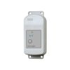
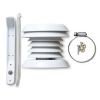
HOBO MX Soil Moisture Loggers
Features
- Ready to deploy, with pre-attached sensors
- Easy configuration and data offload with the free HOBOconnect app
- Durable TEROS 10 soil moisture sensor lasts over 10 years in the field
- Free ground shipping
- Expedited repair and warranty service
- Lifetime technical support
- More
Overview
The HOBO MX Soil Moisture Data Loggers are the industry’s only low-cost, fully integrated soil moisture loggers with Bluetooth wireless data offload. Available in two models--one that measures soil moisture (HOBO MX2306) and one that measures both soil moisture and temperature (HOBO MX2307)--these loggers are ideal for users looking for the accurate data they need to save water, improve crop yields, reduce harmful runoff, and protect ecosystems.
Mechanics
With just a mobile phone, tablet, or Windows laptop running the free HOBOconnect app, users can set up and download data wirelessly via Bluetooth when within 100 feet of the logger, making it easy to retrieve data from hard-to-access field locations. For indoor areas, such as greenhouses, users can add the MX Gateway for remote access to data in the cloud-based HOBOlink software.
| Soil Moisture: Volumetric Water Content (VWC) | |
| Measurement Range |
0.00 to 0.64 m³/m³ in mineral soils 0.00 to 0.70 m³/m³ in soilless media |
| Accuracy |
±0.031 m³/m³ typical in mineral soils that have solution EC <8 dS/m ±0.051 m³/m³ typical in soilless media |
| Resolution |
0.001 m³/m³ |
| Dielectric Measurement Frequency |
70 MHz |
| Temperature Sensor (MX2307) | |
| Range |
-40 to 100°C (-40 to 212°F), with tip and cable immersion in fresh water up to 50°C (122°F) for one year |
| Accuracy |
±0.25°C from -40 to 0°C (±0.45 from -40 to 32°F)
±0.2°C from 0 to 70°C (±0.36 from 32 to 158°F)
±0.25°C from 70 to 100°C (±0.45 from 158 to 212°F)
|
| Resolution |
0.04°C (0.072°F)
|
| Drift |
<0.01°C per year (0.018°F per year)
|
| Response Time |
3 minutes in air moving 1 m/s; 20 seconds in stirred water 4 minutes in air moving 1 m/s with RS3-B Solar Radiation Shield |
| Logger | |
| Operating Range |
-25° to 60°C (-13° to 140°F)
|
| Radio Power |
1 mW (0 dBm)
|
| Transmission Range |
Approximately 30.5 m (100 ft) line-of-sight |
| Wireless Data Standard |
Bluetooth Low Energy (Bluetooth Smart) |
| Logging Rate |
1 second to 18 hours |
| Logging Modes |
Fixed interval (normal, statistics) or burst |
| Memory Modes |
Wrap when full or stop when full |
| Start Modes |
Immediate, push button, date & time, or next interval |
| Stop Modes |
When memory full, push button, date & time, or after a set logging period |
| Time Accuracy |
±1 minute per month 0° to 50°C (32° to 122°F) |
| Battery Type |
2/3 AA 3.6 Volt lithium, user replaceable |
| Battery Life |
2 years, typical with logging interval of 1 minute and Bluetooth Always On enabled; 5 years, typical with logging interval of 1 minute and Bluetooth Always On disabled. Faster logging intervals and statistics sampling intervals, burst logging, remaining connected with the app, excessive downloads, and paging may impact battery life. |
| Memory |
110,000 measurements, maximum (472 kB) |
| Full Memory Download Time |
Approximately 60 seconds; may take longer the further the device is from the logger |
| Dimensions |
Logger housing: 10.8 x 5.08 x 2.24 cm (4.25 x 2.0 x 0.88 in.)
Soil moisture sensor: 7.5 x 5.1 x 2.4 cm (2.95 x 2.02 x 0.95 inches)
Soil moisture sensor needle length: 5.4 cm (2.13 inches) Soil moisture sensor needle diameter: 0.32 cm (0.13 inches) Temperature sensor (MX2307) diameter: 0.53 cm (0.21 in.) Sensor cable length: 2 m (6.56 ft) |
| Weight |
MX2306: 229 g (80 oz) MX2307: 267 g (94 oz) |
| Materials |
Logger: Acetal, silicone gasket, stainless steel screws Soil Moisture Sensor: ASA plastic body with polyurethane epoxy filling and stainless steel pins Temperature Sensor (MX2307): Stainless steel waterproof tip Cable: PVC, UV resistant and rodent repellent (soil moisture sensor cable) |
| Environmental Rating |
Temperature sensor and cable (MX2307): Immersion in water up to 50°C (122°F) for 1 year |
- HOBO MX2306 or HOBO MX2307 Data Logger with 2m cable(s) and attached sensor(s)
- HOBO MX Soil Moisture Logger Quick Start
- Screws
- Cable ties
Select Options


In The News

From Paddles to Phytoplankton: Studying Vermont’s Wildest Lakes
For six months of the year, Rachel Cray, a third-year PhD student at the Vermont Limnology Laboratory at the University of Vermont, lives between a microscope and her laptop, running data. For the other six months, she is hiking and canoeing four of Vermont’s lakes, collecting bi-weekly water samples. Cray studies algal phenology across four lakes in Vermont, US, that have low anthropogenic stress—or in other words, are very remote. Funded by the National Science Foundation Career Award to Dr. Mindy Morales, the lakes Cray researches part of the Vermont Sentinel Lakes Program, which studies 13 lakes in the area and, in turn, feeds into the Regional Monitoring Network, which operates in the Northeast and Midwest US.
Read More
Reimagining Water Filtration: How Monitoring and Science Enhance FloWater Filtration Systems
Over 50% of Americans think their tap water is unsafe , according to the Environmental Working Group (EWG). Other recent surveys have found that number to be as high as 70% of persons surveyed. Whether due to increased public awareness of water quality issues or confusion about how municipal water sources are regulated, there is a clear distrust of tap water in the United States. According to industry expert Rich Razgaitis, CEO and co-founder of the water purification company FloWater, this issue creates a damaging cycle. Razgaitis explained that the health and environmental problems associated with contaminated water aren’t the only issues. As people become increasingly aware that some tap water is unsafe, they resort to bottled water.
Read More
Monitoring New Hampshire’s Aquatic Ecosystems: Continuous Data Collection in the Lamprey River Watershed
New Hampshire’s aquatic ecosystems provide a range of ecosystem services to the state and region. Resources and services like clean water, carbon storage, climate regulation, nutrient regulation, and opportunities for recreation all depend on New Hampshire’s aquatic ecosystems remaining healthy. Jody Potter, an analytical instrumentation scientist at the University of New Hampshire (UNH), is studying these aquatic ecosystems in hopes of developing an improved understanding of ecosystem services and their interactions with climate change, climate variability, and land use changes. [caption id="attachment_39799" align="alignnone" width="940"] Aquatic sensors in the Merrimack River in Bedford, NH, with I-293 in the background.
Read More