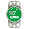
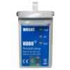
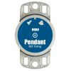
HOBO Pendant Temp/Light Logger
Features
- Low-cost temperature with light intensity
- Waterproof housing for wet or underwater use
- Data readout in less than 30 seconds via fast Optic USB interface
- Expedited repair and warranty service
- Lifetime technical support
- More
Overview
The Onset HOBO Pendant Temp/Light data logger is a miniature, waterproof two-channel temperature and relative light level data logger. The logger is suitable for indoor, outdoor, and underwater applications.
Add-Ons
Use a solar radiation shield for accurate temperature measurement in sunlight. See RS1 Solar Radiation Shield (assembly required) and M-RSA (pre-assembled) Solar Radiation Shield. Note that using a solar radiation shield prevents the use of the light sensor.
Measurement Range
Temperature: -20° to 70°C (-4° to 158°F)
Light: 0 to 320,000 lux (0 to 30,000 lumens/ft2)
Accuracy
Temperature: ± 0.53°C from 0° to 50°C (± 0.95°F from 32° to 122°F), see Plot A in manual
Light intensity: Designed for measurement of relative light levels, see Plot D in manual for light wavelength response
Resolution
Temperature: 0.14°C at 25°C (0.25°F at 77°F), see Plot A in manual
Drift: Less than 0.1°C/year (0.2°F/year)
Response Time
Airflow of 2 m/s (4.4 mph): 10 minutes, typical to 90%
Water: 5 minutes, typical to 90%
Time accuracy: ± 1 minute per month at 25°C (77°F), see Plot B in manual
Operating Range
In water/ice: -20° to 50°C (-4° to 122°F)
In air: -20° to 70°C (-4° to 158°F)
Water depth rating: 30 m from -20° to 20°C (100 ft from -4° to 68°F), see Plot C in manual
NIST traceable certification: Available for temperature only at additional charge; temperature range -20° to 70°C (-4° to 158°F)
Battery life: 1 year typical use
Battery Type: CR2032
Memory
UA-002-64: 64K bytes (approximately 28K combined temperature and light readings or events)
Materials: Polypropylene case; stainless steel screws; Buna-N o-ring
Weight: 18 g (0.6 oz)
Dimensions: 58 x 33 x 23 mm (2.3 x 1.3 x 0.9 inches)
Environmental Rating: IP68
In The News
Regional Lake Monitoring in Maine: Community Funded Research and Protection
Lakes everywhere are threatened by climate change, harmful algal blooms , invasive species, and other environmental stressors. Local, regional, and federal agencies have stepped up in order to defend the environment and water resources. The Lakes Environmental Association (LEA) in Maine is one example of an organization dedicated to protecting local freshwater resources. Dr. Ben Peierls, LEA Research Director, explains the history of the nonprofit, "For more than 50 years, [LEA] has been working locally, statewide, and regionally, helping or interacting with people on lake water quality, watershed protection, conservation, education, invasive species, and other issues.
Read MoreWildfire Prevention in the Sierra Nevada Region with the Yuba Watershed Institute
Though recent wildfires have sparked new conversations about wildfire management and response, groups like the Yuba Watershed Institute have been monitoring the forests and water resources of the Sierra Nevada region for decades, managing approximately 5,000 acres of land with the Bureau of Land Management (BLM) and about 7,000 acres in private land partnerships. The goal of the Institute is to work with local communities and land agencies to improve watershed and forestry management through informed practices and public outreach. The goals of the Yuba Watershed Institute are three-fold: Improve the ability of fire suppression agencies like the California Department of Forestry and Fire Protection ( CAL FIRE ) and the US Forest Service.
Read MoreWave Sensors Integration with NexSens Buoys: A Cutting-Edge Solution for Wave Measurment
Real-time wave data supports accurate weather prediction, safe and efficient maritime operations, and provides valuable safety and operating condition information for recreation and commercial fishing. Understanding wave dynamics also helps with the design of protective coastal structures like seawalls, breakwaters, and jetties. It also supports better prediction of their impact on sediment transport and coastal geomorphology. Wave data is a key factor in qualifying and designing offshore wind farms and harnessing kinetic energy for electrical generation. It helps with the understanding of ocean-atmosphere interactions and contributes to studies of sea-level rise and climate change impacts.
Read More


