
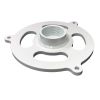
YSI H-3401 Tipping Bucket Rain Gauge
Features
- Two removable stainless steel funnel screens
- Rustproof, powder painted aluminum enclosure and cast base
- Built in microprocessor automatically corrects errors
- Expedited repair and warranty service
- Lifetime technical support
- More
Overview
The YSI H-3401 is a precision tipping bucket rain gauge with SDI-12 output for use in hydro-meteorological applications. The SDI-12 feature converts a standard tipping bucket rain gauge into a “smart” SDI-12 sensor with additional capabilities.
Output Data Parameters
- Accumulated rainfall since last measurement
- Raw bucket count since last measurement
- Total accumulation
- Total daily accumulation (today)
- Total daily accumulation (yesterday)
Easy Integration
The H-3401 is easy to use and works with any data logger with SDI-12 input. It scales the bucket tips into units (inches, meters, etc.) and provides a built-in accumulation of daily and total rainfall. The unit also provides mathematical correction for bucket volume errors due to varying rainfall rate.
| Connectivity / Communications | SDI-Output. Baud Rate: 1200; Protocol: SDI-12, version 1.3; Output voltage levels: Min High level: 3.5 volts, Max low level: 0.8 volts, Max cable length: 250 ft (76 m) |
|---|---|
| Connector | Screw Clamp, for #12-22 AWG wire |
| Operating Temperature | Electronic: -40 ° to +60 ° C; Mechanical: 0 ° to +50 ° C |
| Power | Power Requirements: Voltage Input 10.0 to 16.0 volts DC Standby: 180µA typical; Current Raining: 2.8 mA for 60 seconds Communication: 6 mA |
| Storage Temperature | -50 ° to +70 ° C |
| Mounting | Three anodized aluminum external mounting feet with 0.281" holes |
| Warranty |
2 years |
Select Options


In The News

Three Decades of Research at Acton Lake
A multi-disciplinary team at Miami University, Ohio, has been studying the environmental change at Acton Lake for over three decades. Using three different NexSens buoys over this time, the team has an incredible archive of data that is helping build a picture of Acton’s past, present, and future. Until recently, a NexSens CB-50 buoy was used alongside other environmental monitoring at Acton Lake. In May 2025, the Miami team deployed a new XB-200 buoy , future-proofing their ongoing monitoring using real-time buoy systems. Acton Lake, a small hypereutrophic reservoir in southwest Ohio, covers 2.4km² and has a maximum depth of about 8m. The dam was built in 1956, and the lake has a large agricultural watershed.
Read More
Source Water Monitoring in Albany, New York: Tracing Water Quality throughout Tributaries
Thousands of US cities pull their drinking water from natural source waters like reservoirs, rivers, and streams, making overall watershed health a key consideration for water providers. In Albany, New York, the Albany Department of Water and Water Supply delivers drinking water to over 100,000 residents as well as monitors and manages the larger drinking water supply watershed. Hannah Doherty, Environmental Specialist at the Albany Department of Water and Water Supply , spends her days working with a small team to monitor the drinking supply and the connected water bodies. Doherty explains, “We’re the first to encounter the water that ends up being the drinking water.
Read More
Wildfire Prevention in the Sierra Nevada Region with the Yuba Watershed Institute
Though recent wildfires have sparked new conversations about wildfire management and response, groups like the Yuba Watershed Institute have been monitoring the forests and water resources of the Sierra Nevada region for decades, managing approximately 5,000 acres of land with the Bureau of Land Management (BLM) and about 7,000 acres in private land partnerships. The goal of the Institute is to work with local communities and land agencies to improve watershed and forestry management through informed practices and public outreach. The goals of the Yuba Watershed Institute are three-fold: Improve the ability of fire suppression agencies like the California Department of Forestry and Fire Protection ( CAL FIRE ) and the US Forest Service.
Read More