Info system links hydrological researchers to open source data across the U.S.
A new system for sharing in-situ water data from more than 2 million monitoring sites across the U.S. makes accessing the open source data as simple as a web search.
Rick Hooper, director of the Consortium of Universities for the Advancement of Hydrologic Science, said the program was meant to fill an informational void for hydrological researchers and scientists.
The consortium’s new Hydrologic Information System provides shared in-situ data to water resource professionals, or anyone else interested, based on a geographic information system map.
“This is the culmination of nearly 10 years of work that’s funded by the National Science Foundation,” Hooper said in a recent online seminar hosted by the National Water Quality Monitoring Council.
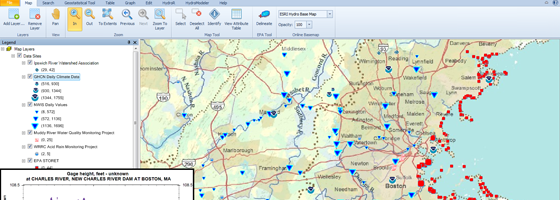
Users access the information system through HydroDesktop, a free program available on the consortium’s website.
Many universities and national organizations, such as the U.S. Geological Survey and the National Oceanic and Atmospheric Administration, contribute data. The information system links searchers to 2.79 million monitoring sites in the U.S.
Hooper said the consortium is always looking for more contributors. “I would like to encourage those of you who are operating monitoring networks to participate,” he said. “We will help you as much as we can.”
The consortiums’ developers have tried to make contributing as easy as possible, constructing a programming language they hope will become a standard. They will also enable server hosting for those who lack a place to easily host their data.
This system’s design is similar to a typical search engine. The data is hosted on servers separate from the information system and retrieved with open source programming. “We never collect the data. We collect the metadata,” said Hooper.
Data submitters catalog their metadata on the information system with tags describing their measurements. This eliminates problems with inconsistent labeling across different organizations.
The information system then uses metadata to sort through all the cataloged data and only returns information relevant to searchers.
Searching for data in the HydroDesktop client program to HIS is simple. Zoom into an area on the map, search for a data category and the system does the rest. The results are retrieved from open source servers and plotted on the map. Users can download the data or graph it in the program.
When it comes to whether people can trust the data, Hooper said the information system is like anything else on the web. “It’s all buyer beware,” he said. “Ultimately it’s up to the data publisher to put what you’ve done (to collect and verify the data).”
A web browser platform for HIS is in the works and should be out by summer.
One thing that won’t happen anytime soon is a client program to access data on Apple computers. Apple users will have to boot up with a Windows operating system until the web browser client is available.
Hooper’s full presentation on the Hydrologic Information System is on the National Water Quality Monitoring Council’s website.


0 comments