NOAA PORTS data system keeps harbors safe with environmental sensors
Navigating ships into harbor — particularly the massive barges used in commercial shipping — is harrowing work. Numerous environmental variables can affect the maneuverability of the bulky ships, and even the smallest variation in water depth can mean the difference between a successful docking or catastrophic grounding.
Mariners in Charleston, S.C., may find their job a little easier, however, as their harbor became the 23rd in the U.S. to utilize a new navigation assistance system designed by the National Oceanic and Atmospheric Association. Known as Physical Oceanographic Real-Time System (PORTS), the system provides important data to ship operators in real-time, allowing them to navigate harbor waterways with greater safety and efficiency.
“By providing integrated real-time tide, weather and bridge clearance information, the Charleston PORTS will help reduce the chances for accidents,” said Richard Edwing, director of
NOAA’s Center for Operational Oceanographic Products and Services, in a press release. To obtain this information, PORTS uses multiple sensors capable of various measurements, including water level, wind speed, barometric pressure and fog visibility.
Atmospheric and marine conditions directly impact the ability of mariners to move cargo in and out of port. A greater knowledge of these conditions allows mariners to increase the amount of cargo moved and profit generated.
No stranger to financial matters, the Port of Charleston handles over $58 billion in commerce per year, according to a NOAA press release. It is the fourth largest port on the East Coast and sees the business of major brands such as Michelin, BMW and Boeing.
PORTS was first employed in Tampa, Fla., in 1991, according to Darren Wright, NOAA PORTS program manager. Since then, 22 other harbors have been fitted with the systems (though Wright noted that one system in Mississippi has been taken offline).
“Prior to PORTS… [mariners relied] on tide predictions and tidal current predictions,” Wright said in an interview. These predictions are based on a 19-year tidal cycle, and do not incorporate meteorological variables that can affect navigation.
“You can run into a situation where you have less water than the predictions are saying,” Wright said. “That’s a recipe for a grounding.” That can be especially disastrous when oil tankers are involved.

Another view of the NOAA PORTS air gap sensor, which provides information for ships that maximize channel depths and push the bounds of bridge heights. (Credit: NOAA)
A key advantage of the PORTS system lies in its self-sufficiency. Wright said that each system operates as a standalone unit, drawing power from either an AC source, or a solar-charged battery.
“Each of the systems has telemetry,” Wright said. “We use both satellite and IP as redundant communications, so if one goes down, we will still receive data through the other.” The data is then collected at a location in Silver Springs, Md., before being disseminated via Internet and a special phone system. Pilots of seafaring vessels can use a mobile device such as a phone or laptop to access the information as they come into port.
Although lack of environmental information can prove troublesome for harbor-bound ships, bad data is equally dangerous. The PORTS response to this problem is a 24/7 quality control operation that allows bad data to be turned off.
Not all harbors are created equal, and each PORTS system is designed with the needs of its location in mind. The systems are assembled “a la carte,” with some boasting over 100 sensors, while others make use of only a few. Consequently, the cost to implement and maintain PORTS systems varies by case. Wright noted that the Charleston system costs around $20,000 in annual upkeep.
According to NOAA, the cost of the PORTS system is far exceeded by its financial return. The organization points to two major studies to support these claims, including one in the Houston/Galveston areas that revealed a $14 million to $15 million annual economic benefit. The other study examined PORTS systems in Tampa-St. Petersburg, demonstrating a combined savings and direct income of $7 million.
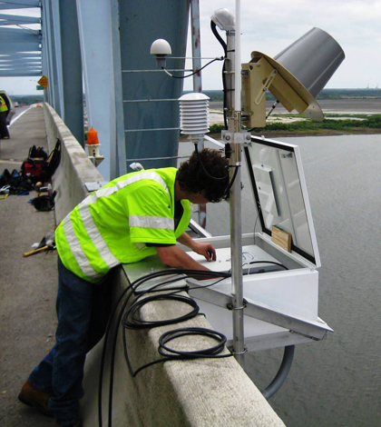
Top image: A CO-OPS employee installs an air gap sensor which measures bridge clearance on the Don Holt Bridge for the NOAA PORTS system inCharleston, S.C. (Credit: NOAA)


0 comments