Data from a few Sierra Nevada white firs give clues to fate of species
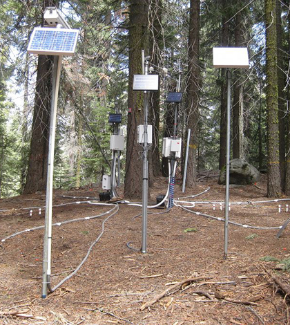
Critical Zone Tree 1 surrounded by instruments measuring soil temperature and moisture and other elements of the local water balance (Credit: Southern Sierra Critical Zone Observatory)
Somewhere in the Sierra Nevada mountains in California, a single white fir tree is feeding scientists data that could help predict the species’ fate as it responds to climate change.
The tree, dubbed Critical Zone Tree 1, is threaded with sensors measuring its sap flow and the volume of water sucked up by its roots and emitted from its canopy as vapor. More instruments radiate in spokes into the space around the tree, some standing on the the surface and others buried in the soil, measuring temperature and moisture.
The tree is within the borders of the Southern Sierra Critical Zone Observatory, one of six such National Science Foundation-funded observatories around the country. These facilities peer into the thin layer–on a planetary scale, anyway–from the deep bedrock to the lower atmosphere. Put another way, that’s “Everything near the land surface that sustains life,” according to Jan Hopmans, professor of vadose zone hydrology at University of California Davis and an investigator on the tree project.
Research across the observatories focuses broadly on how water moves between the soil and the atmosphere. Trees play an important role in that movement, in effect closing the hydrologic cycle by drawing water from the ground and emitting it back into the atmosphere.
In the Sierra observatory, there’s a particular interest in how the range’s various tree species will respond to projected changes in temperature and precipitation. Before researchers can project the effects on an entire species, they need to zoom in on an individual member. Critical Zone Tree 1 will help measure the response of a single white fir.
“The specific study we did as part of this Critical Zone Observatory is to really narrow down to a very local scale–at the tree level–and measure the heck out of it and see what we can find,” Hopmans said.
They’re looking for a better quantification of how water moves through the soil, into the tree’s roots, then up the trunk to the canopy where it eventually transpires into the atmosphere. With data from the array of sensors describing that process, they’ll be able to model how a single tree might respond to temperature or moisture stress.
For example, trees respond to rising temperatures by closing pores in their leaves or needles, which reduces how much water vapor they release. That means less transpiration, but to what magnitude does that happen for that particular tree?
“These are some of the very fundamental questions that are actually pretty complicated,” Hopmans said. “Because now you’re talking about soil science, plant physiology, climatology, biology–all these different disciplines come together when you start looking at this in an integrated way.”
")
A LiDAR image of the root structure of a neighboring, similarly-sized white fir to Critical Zone Tree 1 (Credit: Southern Sierra Critical Zone Observatory/UC Davis)
In an effort to better integrate the structure and function of the tree into the modeling, the soil around a neighboring white fir was excavated at the recommendation of Alison Berry, a professor of plant sciences at UC Davis. Crews worked for a week to blast away dirt with pressurized air to expose the roots without damaging them. Once the roots were clear, the researchers created a 3-D model using LiDAR and other imaging tools. That will help quantify how the roots are likely distributed below similarly-sized white firs, creating a clearer picture of where an individual tree is pulling is moisture from the soil.
The Critical Zone Tree project was recently awarded five more years of funding from the NSF, and the team has already instrumented additional trees. Coupled with landscape-scale measurements from other monitoring efforts in the observatory, the data from those few individuals could give scientists an idea of how swaths of the the Sierra Nevadas might look like in the next century.
“If the temperature is changing or the precipitation is changing, there will be an impact,” Hopmans said. “Possibly, certain tree species won’t be able to survive. And so the question is, Which species will not survive, and which ones are the most vulnerable?”
Top image: Critical Zone Tree 1 surrounded by instruments measuring soil temperature and moisture and other elements of the local water balance (Credit: Southern Sierra Critical Zone Observatory/UC Davis)


0 comments