
Eno Scientific Well Sounder 2010 PRO Water Level Meter
- Free ground shipping
- Expedited repair and warranty service
- Lifetime technical support
- More

- Automatic temperature compensation
- Calculate drawdown and recovery rates
- Data points stored in non-volatile memory
Overview
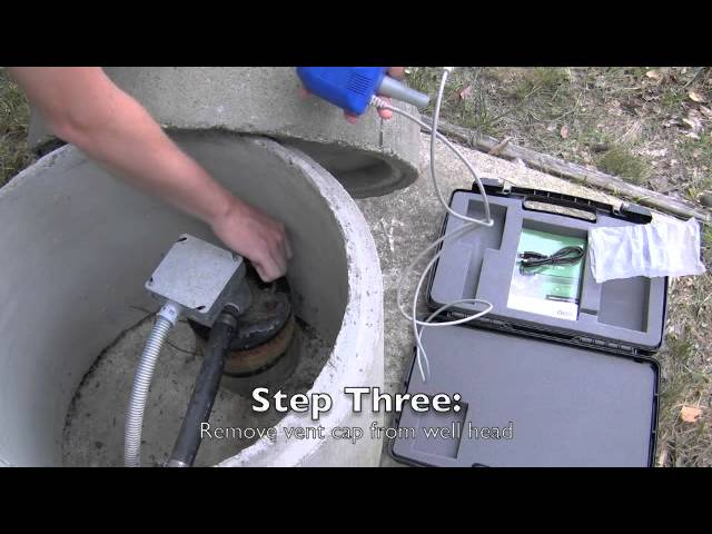
The Eno Scientific 2010 PRO is a portable sonic water level meter that uses sound waves to measure the distance from the top of the well to the water level, eliminating the need to lower anything into the well and preventing well contamination. Simply place the probe into a well cap vent opening and turn the unit on. Within seconds, the static water level measurement is displayed. With the press of a button, the instrument calculates and displays a variety of other information such as the total water in the well, rate of change, temperature, and battery voltage.
Built-in Data Logger
The Eno Scientific 2010 PRO can record up to 13,000 time-stamped readings along with the well ID, temperature, and other associated measurements. The logger can be set to take measurements automatically at intervals between 1 and 60 minutes, or manually by pressing the LOG button on the keypad. The recorded data can be reviewed on the screen or downloaded to a computer for analysis using the serial RS-232 port or the included USB cable. Stored data is formatted in simple Windows-compatible text files sorted by well ID. Data can be easily copied from the instrument onto the computer and opened with almost any common program such as Word, Excel, or Notepad.
Other Features
Includes a power save mode, which puts the unit to sleep between measurements when logging and turns the power off after a selected period of inactivity. If there are known defects in the well, such as a rock fissure, simply set the measurement range minimum and maximum to ignore the interference. The multi-purpose bi-directional serial port can also be used to transmit data in real-time to a remote readout or logging device.
- Power
- Internal Power: 6 AA Alkaline batteries
- External Power (Optional): 5.5 to 12VDC at 50ma
- Real-Time Clock: Li Ion 3V battery CR2032
- Measurement
- Resolution: .05 ft
- Accuracy: 0.1 ft
- Range: 9 to 2000 ft
- Temperature Compensation: Built-in to probe
- Logging
- Memory: Non-volatile flash memory for 13,000 data points
- Logging Rates: 1 second to 60 minutes
- Environmental
- Temperature: -10 to 110 F
- Humidity: 10 to 90% non-condensing
- Physical
- Dimensions: 4"x 7.5"x 1.25"
- Weight: ~13 oz
- Display: 2x16 character LCD
- Outputs
- USB port: For access to file system
- Serial Output: 300 to 57600 baud, 8 data bits, 1 stop bit (19200 baud default)
- (1) Well Sounder 2010 PRO meter
- (1) Probe with 6 ft cable
- (1) USB cable
- (1) Carrying case
- (1) US Groundwater Temperature Chart
- (1) Quick Start Guide
- (1) User Manual
- Automatic temperature compensation
- Calculate drawdown and recovery rates
- Data points stored in non-volatile memory
Overview
The Eno Scientific 2010 PRO is a portable sonic water level meter that uses sound waves to measure the distance from the top of the well to the water level, eliminating the need to lower anything into the well and preventing well contamination. Simply place the probe into a well cap vent opening and turn the unit on. Within seconds, the static water level measurement is displayed. With the press of a button, the instrument calculates and displays a variety of other information such as the total water in the well, rate of change, temperature, and battery voltage.
Built-in Data Logger
The Eno Scientific 2010 PRO can record up to 13,000 time-stamped readings along with the well ID, temperature, and other associated measurements. The logger can be set to take measurements automatically at intervals between 1 and 60 minutes, or manually by pressing the LOG button on the keypad. The recorded data can be reviewed on the screen or downloaded to a computer for analysis using the serial RS-232 port or the included USB cable. Stored data is formatted in simple Windows-compatible text files sorted by well ID. Data can be easily copied from the instrument onto the computer and opened with almost any common program such as Word, Excel, or Notepad.
Other Features
Includes a power save mode, which puts the unit to sleep between measurements when logging and turns the power off after a selected period of inactivity. If there are known defects in the well, such as a rock fissure, simply set the measurement range minimum and maximum to ignore the interference. The multi-purpose bi-directional serial port can also be used to transmit data in real-time to a remote readout or logging device.
- Power
- Internal Power: 6 AA Alkaline batteries
- External Power (Optional): 5.5 to 12VDC at 50ma
- Real-Time Clock: Li Ion 3V battery CR2032
- Measurement
- Resolution: .05 ft
- Accuracy: 0.1 ft
- Range: 9 to 2000 ft
- Temperature Compensation: Built-in to probe
- Logging
- Memory: Non-volatile flash memory for 13,000 data points
- Logging Rates: 1 second to 60 minutes
- Environmental
- Temperature: -10 to 110 F
- Humidity: 10 to 90% non-condensing
- Physical
- Dimensions: 4"x 7.5"x 1.25"
- Weight: ~13 oz
- Display: 2x16 character LCD
- Outputs
- USB port: For access to file system
- Serial Output: 300 to 57600 baud, 8 data bits, 1 stop bit (19200 baud default)
- (1) Well Sounder 2010 PRO meter
- (1) Probe with 6 ft cable
- (1) USB cable
- (1) Carrying case
- (1) US Groundwater Temperature Chart
- (1) Quick Start Guide
- (1) User Manual
Select Options


PRODUCT VIDEOS


Customer Stories


