BOB and MARI Will Monitor Water Chemistry in the San Francisco Bay
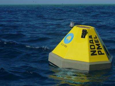
A mooring with a suite of ocean acidification and other environmental sensors of a similar kind at Heron Island on the Great Barrier Reef. (Credit: Dr. Bronte Tilbrook, CSIRO, Australia)
Scientists have had nagging questions about how ocean acidification might be affecting the waters of the San Francisco Bay. But if you can’t trust BOB and MARI with your research questions, who can you trust?
That’s BOB, the Bay Ocean Buoy and MARI, BOB’s companion mooring for Marine Acidification Research Inquiry, of course.
BOB and MARI are a bright yellow, five-foot tall buoy and its companion mooring, respectively. They are anchored near the Estuary and Ocean Science (EOS) Center of San Francisco State University (SFSU). SFSU researchers are collaborating with scientists from the University of California, Davis and other funders and partner organizations on the first long-term project to monitor carbon dioxide and ocean acidity in the San Francisco Bay.
Karina Nielsen, Director of the EOS Center and Professor of Biology at SFSU, corresponded with EM about BOB and MARI and the project.
“We are interested in learning more about how changing ocean and watershed conditions may influence the pH and carbonate chemistry of SF Bay waters,” Dr. Nielsen explains. “We know the ocean is becoming more acidic and ocean waters have a strong influence on the ecology of the bay, yet we have no idea how changing ocean acidity is influencing SF Bay. BOB is taking measurements of CO2 in the water and in the air, along with pH and a suite of other water quality properties at the surface of the bay. MARI’s instrument package is at the bottom of the bay instead of at the surface, measuring pH and other water properties.”
BOB and MARI moorings will also track changes in chlorophyll-a, dissolved oxygen, salinity, temperature, and water clarity.
The team aims to explore how climate change and the fluctuations in marine chemistry it triggers are affecting local conservation and habitat restoration projects. If all goes to plan, BOB and MARI will provide data that will help the team identify the management solutions with the most promise, so that policymakers can make wise investments into the environmental health of the San Francisco Bay.

BOB the buoy, being deployed in the Bay. (Credit: Lisa Vortman, from press release)
Long-term, multidirectional monitoring
The San Francisco Bay is a locus for many kinds of water to mix. Here rivers empty into the ocean, and runoff from the land does also. These obvious sources of pollution have grabbed the lion’s share of attention from people hoping to keep the Bay clean, and for good reason. However, experts now recognize the upwelling of cold, deep ocean waters and the ability of those waters to absorb carbon dioxide produced by fossil fuel consumption as a pressing issue in the Anthropocene age. The CO2 absorbed by the water is causing ocean acidification, and although we know that acidification can affect mussels, corals, and other creatures, the entire range effects of this process are as yet unknown.
BOB and MARI will help scientists monitor the water in the Bay in a multidirectional way, rather than just focusing on water entering the Bay.
“We have long known that the salty ocean waters flowing into the bay have a profound influence on the ecology of the entire estuary,” Dr, Nielsen details. “Now that the ocean is changing, becoming more acidic, holding less oxygen, and warming due to climate change, we need to account for these new conditions. With this additional scientific information we will be able to make better decisions for how we manage the health of the bay through restoration, conservation, adaptation and other management actions.”
BOB is a moored buoy system, called a MAPCO2 system, designed to measure the partial pressure of CO2 (pCO2) in the atmosphere and the water. It was developed at the Monterey Bay Aquarium Research Institute and NOAA beginning in 2004 for this kind of research.
“In a nutshell, the MAPCO2 system collects pCO2 measurements from marine boundary air and surface seawater and in our deployment it does this hourly,” Dr. Nielsen describes. “It uses a special equilibrator, an infrared gas analyzer and a calibration gas to make accurate measurements of both aqueous and atmospheric pCO2.”
The SeaFETTM instrument is also deployed on BOB to measure pH with an ion-sensitive field-effect transistor sensor. BOB is also packing a standard oceanographic thermos-salinograph, augmented with additional sensors, which measures dissolved oxygen, salinity, surface water temperature, turbidity, and chlorophyll-a, a measure of phytoplankton abundance.
Daily CO2 measurement summary files are transmitted via satellite and posted to the web in near-real time, online here. In 2009, the MAPCO2 technology was moved into commercial production at Battelle Memorial Institute. MARI is a smaller mooring system with a bottom deployed SeapHOx™ to measures pH, using the same technology as the SeaFET, along with temperature, salinity and dissolved oxygen.
As long-term residents in the Bay, BOB and MARI will provide not only in-the-moment snapshots of water conditions on any given day, but also detailed views of how the water is changing over time.

Screenshot of real-time CO2 data plot. (Credit: https://www.pmel.noaa.gov/co2/pco2data/graphite/tiburon_public_diagnostics.shtml)
The team chose the sites where deployed BOB and MARI moorings and their sensors are taking measurements deliberately; it wasn’t an easy process. The instruments and moorings are on the northeastern shore of the Tiburon Peninsula, in front of the Estuary & Ocean Science Center. There is a deep-water channel very close to shore in that location.
“Our primary science consideration was to locate them in a deep-water site where we can measure the denser, most acidic ocean waters as they enter the bay along the bottom,” Dr. Nielsen remarks. “We also had to make sure we could get permission of the landowner to anchor the instruments, avoid shipping channels, et cetera. The permitting was challenging and took almost two years to complete.”
Looking ahead in partnership
Monitoring the carbon chemistry of the Bay is an important tool for revealing how climate change and changing ocean chemistry impact with local conservation and habitat restoration efforts.
For example, eelgrass meadows and oysters reefs are among the most ecologically important intertidal and subtidal habitats for wildlife in the San Francisco Bay area. These habitats are conserved and restored for their ecological value. Researchers are also exploring their use in “living shorelines,” a nature-based approach to creating shoreline resilience to rising sea levels.
“Eelgrass meadows have the capacity to remove CO2 from the water during photosynthesis and to trap and store carbon-rich sediments,” Dr. Nielsen details. “Oysters and other organisms that form shells or other hard parts from calcium carbonate are vulnerable to acidic waters. If the waters of San Francisco Bay are becoming more acidic, the oysters we are trying to restore may have a harder time growing and surviving. Perhaps restoring more eelgrass can help, while providing other important benefits, but we can’t know this without measuring and understanding the carbonate chemistry of the waters these plants and animals live in. The measurements BOB and MARI are making will help us develop more effective solutions for coastal adaption, restoration and conservation in SF Bay.”
BOB and MARI and the project are supported not only by Dr. Nielsen, the Estuary and Ocean Science Center and San Francisco State University, but by a dedicated team of experts who will see the project through.
“I am working with my scientific collaborator Dr. John Largier from UC Davis, and the project is being supported by various federal partners,” adds Dr. Nielsen. “The Carbon Group at the National Oceanic and Atmospheric Administration’s (NOAA’s) Pacific Marine Environmental Laboratory is providing technical support. The U.S. Environmental Protection Agency (through the San Francisco Estuary Partnership) and the Central and Northern California Ocean Observing System (CeNCOOS), a regional association of NOAA’s U.S. Integrated Ocean Observing System, provide financial support.”
As new residents of the Bay, BOB and MARI should soon be participating in conservation and restoration efforts in a singularly important way.


0 comments