How North Carolina’s CORMP Program’s Coastal Monitoring Goes Beyond Data Collection
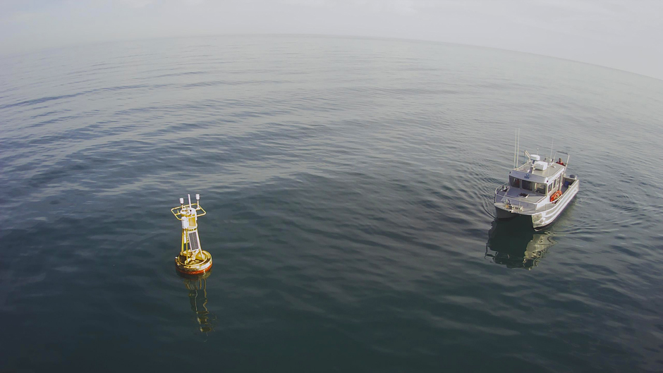
It’s late 1999, and two buoys float inconspicuously in the brackish water of Cape Fear, at the southern end of North Carolina. The tides ebb in and out from the Atlantic Ocean, the buoys bobbing on the surface as the waves roll in.
The buoys are part of the University of North Carolina Wilmington’s Coastal Ocean Research and Monitoring Program (CORMP). Started in the late 1990s as a congressional earmark to fill the gaps left by the National Weather Service’s “blind spots,” CORMP’s buoy program would soon grow into an expansive coastal monitoring network.
It didn’t take long for other organizations to take notice of their work. In 2007, NOAA established its Integrated Ocean Observing System (IOOS), which CORMP quickly joined. And in 2008, CORMP partnered with the newly formed Southeast Coastal Ocean Observing Regional Association (SECOORA).
Along the way, CORMP added monitoring sites up and down the coast, expanding into the Atlantic north of Wilmington and along the South Carolina and Florida coasts. While most sites are offshore buoys collecting continuous atmospheric and subsurface water quality parameters, they also operate several onshore weather monitoring stations.
Now, they have over a dozen monitoring sites collecting invaluable real-time data on the weather and coastal conditions of America’s Southeast.
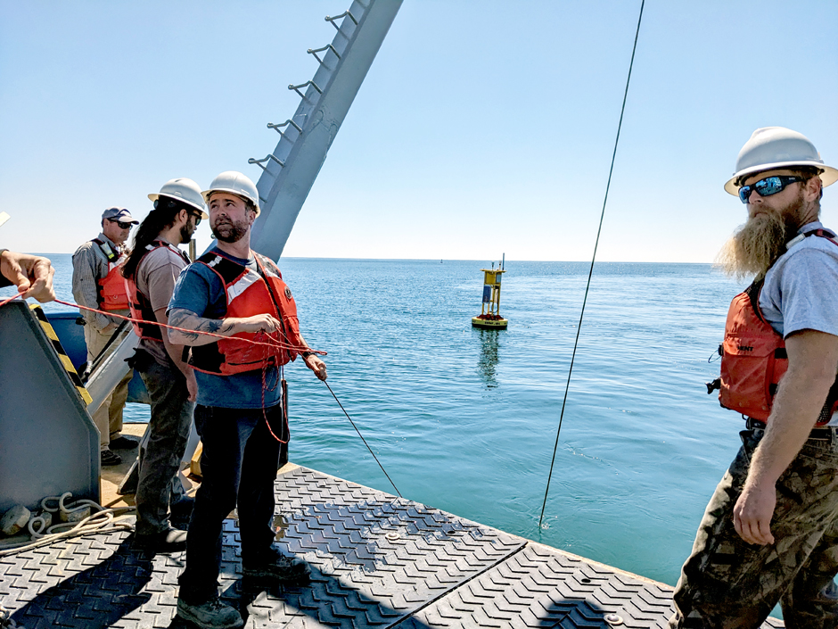
The CORMP crew utilizes UNCW’s RV Seahawk to perform maintenance on a MET/OCE buoy off Wrightsville Beach, NC. (Credit: Chris LaClair)
Matching the Needs of Real-Time Coastal Monitoring
As the 2000s grew into the 2010s, technology advanced, and the needs of CORMP’s partnering agencies changed. Environmental monitoring expanded beyond merely forecasting weather conditions, and private users began requesting access to the data coming from CORMP’s monitoring sites.
Nowadays, CORMP collects data on everything from storm cells making landfall to the movement of sediment along North Carolina’s sandy shoals, explains CORMP’s Principal Investigator Lynn Leonard.
“As NOAA’s needs changed and there was an emphasis on moving to more real-time data […] we focused more on establishing the buoys to measure weather, sea surface conditions, and also waves,” Leonard says. “And we transitioned from a non-real-time emphasis to a real-time emphasis.”
Now, the project provides continuous, real-time nearshore and offshore data to the public. Leonard has led CORMP for over 20 years and says that its data primarily serves other projects and organizations.
CORMP rarely conducts its own research. Rather, it helps anyone from the Coast Guard to harbourmasters by providing them with data from one of their many sites. For example, in 2005, the Port of Charleston, South Carolina, reached out to CORMP because they wanted help forecasting their harbour’s wave conditions.
CORMP set up a buoy site just off the port, and it’s been collecting data for 20 years. And so the process has gone for years, where new sites are established for industry, federal organizations, or even private groups.
Leonard says that the Weather Service rarely opposed their desire to expand sites, which range from offshore buoys to coastal weather stations.
“We started as a research program, but over time we realized the value of making sure that this data could be used by a lot of different users,” Leonard says. “We like to say that our research focus is ‘use-inspired.’”
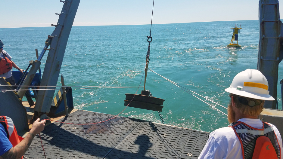
Deployment of the 2000# anchor is the final step in deployment of one of CORMP’s MET/OCE buoy sites. (Credit: Luke Edwards)
Promoting Public Safety Through Data-Driven Forecasting
Today, CORMP fully embraces its role as a program that provides base data for a vast number of projects. According to Leonard, they focus heavily on “back-end data management [that] meets the needs of scientists.”
The data collected on atmospheric conditions, wave height and direction, the movement of cold plumes from the sea floor, and a host of other measurements is collected and disseminated by CORMP.
This data is sometimes fed into forecast models by the National Weather Service, NOAA, and other organizations. These models support products such as coastal waters and surf zone forecasts, small craft advisories and gale warnings, rip current forecasts, and special marine warnings.
However, this is not the only place that CORMP’s data is utilized. Perhaps even more importantly for Leonard, the real-time nature of their remote monitoring systems allows CORMP to provide continuous atmospheric and oceanic conditions during emergencies.
Leonard explains that when a hurricane is forecasted to make landfall within the CORMP footprint, such as Hurricane Ian in 2022, the team coordinates with local weather forecast offices to modify real-time reporting frequencies.
By increasing the frequency of atmospheric pressure and wind direction reports, Weather Forecast offices have more information to make last-minute decisions. In addition to informing NWS tropical storm advisories and hazard warnings (rip currents, storm surge, tornadoes), CORMP data are also used to validate forecasts, wave models, and develop storm climatologies after an event.
Another example is CORMP’s data being utilized by local public stakeholders in Fripp Island, SC, where a remote community dozens of miles from the nearest Coast Guard station organizes its own search and rescues. The Fripp Island Sea Rescue team is able to use the real-time, publicly available data to inform operations.
“We just try to find out where there’s a need for our data,” Leonard explains.
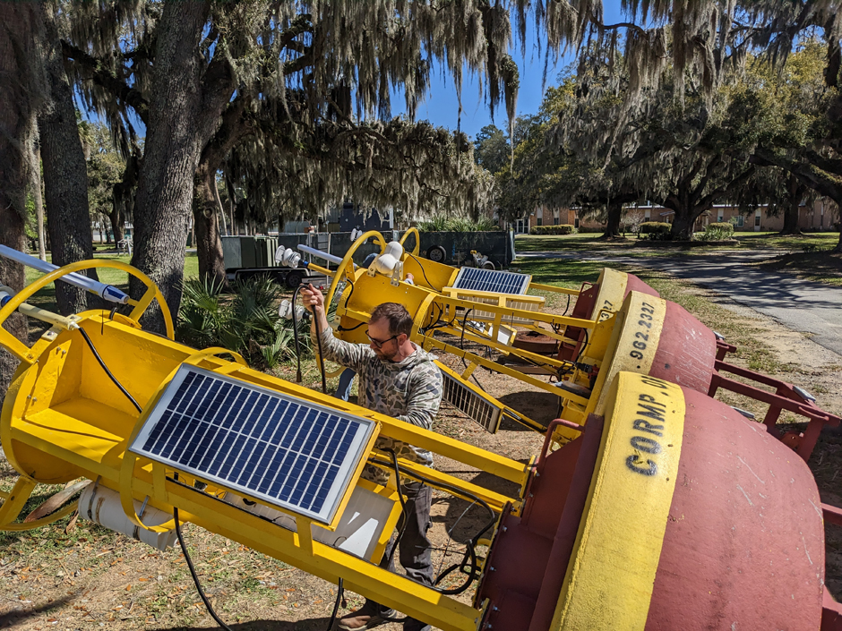
CORMP tech, Chris LaClair, installs the datalogger, power systems, and sensors on new MET/OCE buoys headed for deployment off of SC. (Credit: Luke Edwards)
Expanding Long-Term Monitoring and Supporting New Projects
Many of the sites that have been added to CORMP’s network have been “inherited” from someone else’s discontinued project, according to Program Manager Chris LaClair. When research projects only last a few years, the data can become lost in time.
To combat this and grow their monitoring network at the same time, CORMP will take over these sites, which is what led to their first land-based meteorological sites on the north and south ends of Masonboro Island, NC.
“It’s not always easy, but if there’s something out there and they’re collecting data and we can adopt it into our system and kind of keep it going, we definitely try to do that,” says Leonard.
Similarly, CORMP also updates existing sites to ensure their technology stays up-to-date. Near North Carolina’s Little River Inlet, wave data have been collected since 2010, and the site was equipped with a NexSens CB-650 data buoy and Seaview SVS603 wave sensor for a time.
LaClair and Leonard also collaborate with other organizations. Beyond sharing data and taking over sites, they even allow them to conduct entirely separate projects on CORMP’s sites.
Since its inception, some of the most significant data that CORMP has been involved in collecting has been the movement of sand along the Frying Pan Shoals off of Bald Head Island, which sits on the edge of Cape Fear. Much of the ocean bottom around the cape is rocky, with benthic organisms and fish utilizing the hard surface.
When those sands shift, which can occur with even mild winds, it can alter these ecosystems, according to Leonard. As this was being discovered, ecologists were using the CORMP monitoring sites to aid their research and understand sedimentation below the waves.
“So while we don’t necessarily focus so much on the ecology, we do partner with the researchers that do,” Leonard says.
Further south, the FACT Network also uses CORMP’s Florida buoys to acoustically track wildlife movement. Their receivers simply have a house aboard CORMP’s buoys to receive the telemetry signals as wildlife swims past.
“We offered to provide our sites as locations that we could service the receivers, go out and swap them out, download data, pass that data onto their network, and it just broadens their array,” LaClair says of their partnership.
CORMP technician Doug Faircloth prepares to hook into a MET/OCE buoy for recovery onboard the RV Savannah. (Credit: Chris LaClair)
Collaboration and Public-Facing Data
Collaboration, freedom of information, and offering a “platform of opportunity” to other scientists are vital to what CORMP stands for. Enhancing and collecting data from their long-term monitoring network is a priority, but they relish the opportunities to aid outside research projects and modeling whenever they can.
To continue with their forward-facing persona, it’s key to engage with the public. They are a local organization, so Leonard starts by letting people know that the “university up the road” is actively involved in the federal programs that are creating the forecasts people see each morning on their TV.
SECOORA takes the data from CORMP and others in the area and compiles it into a regional database. Then the National Weather Service, or NOAA’s National Data Buoy Center, takes the regional data and creates nationwide weather and ocean models.
So, when Leonard pops into a local surf shop and sees the conditions forecast on their screen, she smiles to herself. That data made its way up the ranks of CORMP’s collaborators to the federal level, and now anyone planning to head out on the ocean can use the data.
As beachgoers whip by the buoys on their boards, CORMP’s data collection network continues plugging along, helping surfers and scientists alike make sense of the ocean.
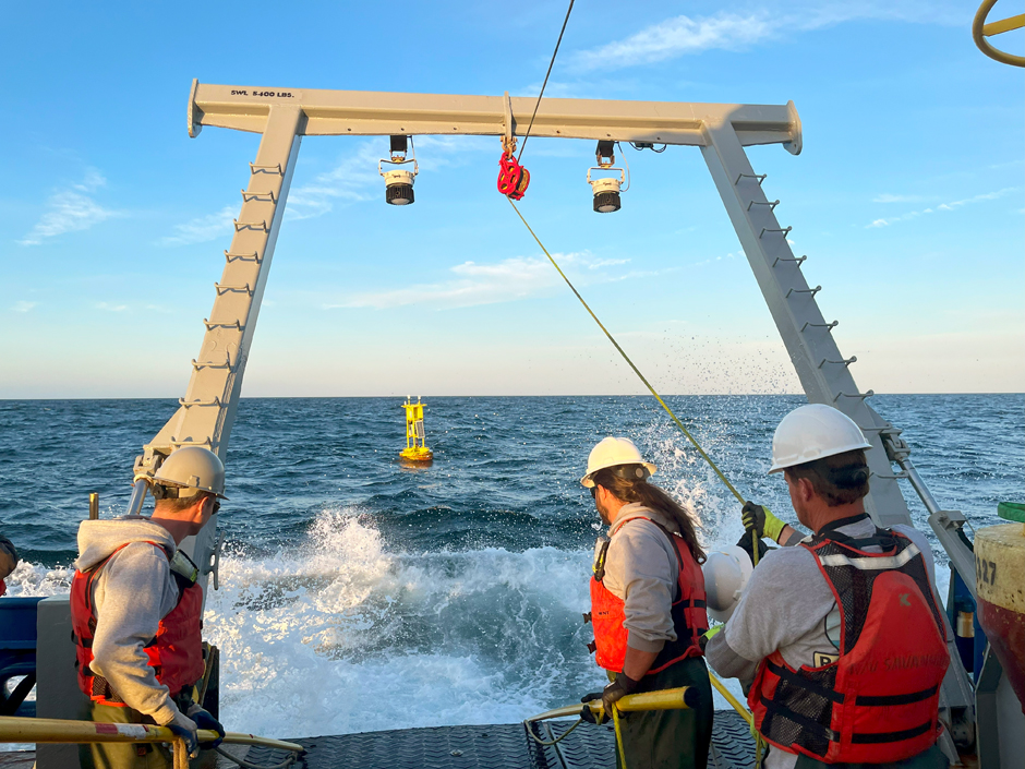
CORMP technicians, Chris LaClair and Doug Faircloth, work alongside RV Savannah crew members to deploy a new buoy and mooring offshore of Charleston, SC. (Credit: Luke Edwards)


0 comments