Remote cameras, environmental sensors advance dust storms research
Dust storms in the Southwest U.S. affect the region’s climate, air quality and ecosystems. It’s important for scientists to know how often the storms happen, but they don’t necessarily want to stand around in the Mojave Desert with a tally sheet, waiting for the wind to whip up a massive cloud of dirt.
A novel approach to tracking the storms developed under the U.S. Geological Survey has helped scientists get a handle on how often and under what conditions the storms occur. Now researchers are applying the method to studies as far flung as the coral reefs of Hawaii and the sandbars at the bottom of the Grand Canyon.
Around a decade ago, scientists studying the storms wanted to know not only how often the storms occurred but also whether they were happening more often than indicated by satellite imagery.
“What we really wanted to do, short of sticking somebody out there to count dust storms or just rely on anecdotal evidence from people who would happen to report them to us, was to actually put cameras out there to take pictures on a regular basis,” said Rian Bogle, lead physical scientist with the USGS Flagstaff Science Center in Arizona. “That way we could get a count so we could actually quantify, month to month, how many visible dust events happened in certain locations.”
One way to capture pictures like that would be to set up a time-lapse camera that automatically shoots a photograph every so many minutes, hours or days. But Bogle and his colleagues went a step further. They developed a system that connects a remote camera and a variety of environmental sensors to a programmable data logger. This allows the camera to lie dormant until the wind speed sensor says that the wind is blowing fast enough to kick up a dust storm.
")
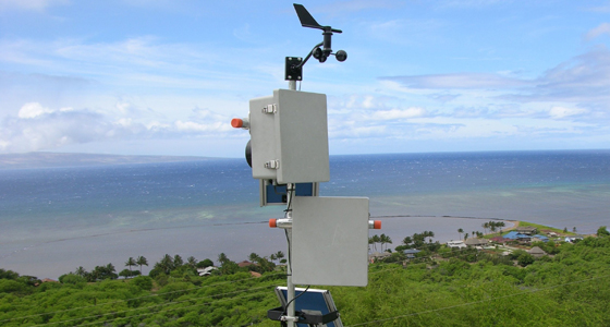
Dust monitoring system deployed in the Mojave Desert on a mountaintop to provide a wide-area perspective. (Credit: Rian Bogle/USGS)
“For the dust applications, the research is pretty solid on what wind speeds need to exceed in order to start moving soil on the ground,” Bogle said. “We calculated what that would be for the height of our anemometer, and then we check that every ten minutes to see if we’re exceeding that threshold. Then that starts the camera shooting.”
Bogle has since helped deploy imaging systems for monitoring sediment on the coasts of Hawaii and Guam. On the floor of the Grand Canyon, automated cameras are tracking whether controlled floods from the Glen Canyon dam can help rejuvenate the formation of sandbars, an important habitat for plants and native fish that has diminished since the dam was built.
“Because (the data logger) has a whole host of other sensor inputs, it’s sort of wide open as to what you would want to trigger that camera with,” Bogle said. “You could easily do that for flood stage if you had a sensor that was measuring a river gauge station. You could easily start taking pictures based off of that.”
Coral reef monitoring in Molokai, Hawaii (Credit: Rian Bogle, USGS)
The USGS recently published a guide on the methods and equipment to help other researchers assemble similar systems. The guide lists the specific camera and data logger used for the dust storm setup, but Bogle said the system is not brand specific. Some basic circuitry knowledge is necessary, but it’s nothing beyond what might be covered in a high school electronics class. Some coding is also involved, but data logger manufacturers tend to offer plenty of support in generating programs, Bogle said.
Though a background in software development like Bogle’s isn’t required, it’s worked out for him. It certainly hasn’t kept him stuck behind a desk, hunched over a keyboard.
“One of the joys of my job is doing field work and getting out deploying these things and testing them,” he said. “I’ve been super lucky. I’ve got a graduate degree in applied mathematics and I’m probably one of the few applied mathematicians who actually does field work and gets his hands dirty.”
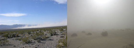
Top image: A dust storm in the Mojave Desert, captured simultaneously from two different perspectives using this automated imaging system (Credit: Rian Bogle/USGS)


0 comments