
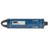
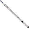
HOBO Fresh Water Conductivity Logger
Features
- Non-contact sensor provides long life and less measurement drift
- Provides easy access to sensor for cleaning and shedding air bubbles
- Requires HOBOware Pro Software and optic base station or waterproof shuttle
- Free ground shipping
- Expedited repair and warranty service
- Lifetime technical support
- More
Overview
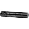
The Onset HOBO U24 high-accuracy conductivity data logger is a cost-effective way to collect water quality data. The HOBO U24 measures and records both conductivity and temperatures in streams, lakes, and other freshwater sources. The Onset HOBO U24 logger is recommended for monitoring aquifers for saltwater intrusion and road and agricultural runoff. This product’s open access to its sensor simplifies cleaning and maintenance. The U24’s non-contact sensor minimizes measurement errors related to drift and features software-based drift compensation.
Low-Maintenance
The HOBO U24 Conductivity data logger features a non-contact sensor with a Titanium Pentoxide coating. This coating prevents the sensor from coming in contact with the water, which in turn prevents tarnishing or corrosion associated with traditional electrode sensors. This sensor coating is also inert, enabling fouling to be easily wiped off the sensor.
| Measurements | Actual Conductivity, Temperature, Specific Conductance at 25°C (calculated) |
| Conductivity Calibrated Measurement Ranges | Low Range: 0 to 1,000 µS/cm Full Range: 0 to 10,000 µS/cm |
| Conductivity Calibrated Range - Temperature Range | 5° to 35°C (41° to 95°F) |
| Conductivity Extended Ranges | Low Range: 0 to 2,500 µS/cm Full Range: 0 to 15,000 µS/cm |
| Temperature Measurement Range | -2° to 36°C (28° to 97°F) |
| Specific Conductance Accuracy (in Calibrated Range) | Low Range: 3% of reading, or 5 µS/cm, and Full Range: 3% of reading, or 20 µS/cm, whichever is greater, using Conductivity Data Assistant and calibration measurements |
| Conductivity Resolution | 1 µS/cm |
| Temperature Accuracy | 0.1°C (0.2°F) at 25°C (77°F) |
| Temperature Resolution | 0.01°C (0.02°F) |
| Conductivity Drift | Less than 3% sensor drift per year, exclusive of drift from fouling |
| Response Time | 1 second to 90% of change (in water) |
| Operating Range | -2° to 36°C (28° to 97°F) - non-freezing |
| Memory | 18,500 temperature and conductivity measurements when using one conductivity range; 11,500 sets of measurements when using both conductivity ranges (64 KB total memory) |
| Sample Rate | 1 second to 18 hrs, fixed or multiple-rate sampling with up to 8 user-defined sampling intervals |
| Clock Accuracy | ±1 minute per month |
| Battery | 3.6 Volt lithium battery |
| Battery Life | 3 years (at 1 minute logging) |
| Maximum Depth | 70 m (225 ft) |
| Weight | 193 g (6.82 oz), buoyancy in freshwater: -59.8 g (-2.11 oz) |
| Size | 3.18 cm diameter x 16.5 cm, with 6.3 mm mounting hole (1.25 in. diameter x 6.5 in., 0.25 in. hole) |
| Wetted Housing Materials | Delrin®, epoxy, stainless steel retaining ring, polypropylene, Buna rubber O-ring, titanium pentoxide (inert coating over sensor) |
| Environmental Rating | IP68 |
- HOBO U24-001 Conductivity Data Logger
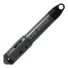
- Communications window protective cap
Select Options


In The News

Three Decades of Research at Acton Lake
A multi-disciplinary team at Miami University, Ohio, has been studying the environmental change at Acton Lake for over three decades. Using three different NexSens buoys over this time, the team has an incredible archive of data that is helping build a picture of Acton’s past, present, and future. Until recently, a NexSens CB-50 buoy was used alongside other environmental monitoring at Acton Lake. In May 2025, the Miami team deployed a new XB-200 buoy , future-proofing their ongoing monitoring using real-time buoy systems. Acton Lake, a small hypereutrophic reservoir in southwest Ohio, covers 2.4km² and has a maximum depth of about 8m. The dam was built in 1956, and the lake has a large agricultural watershed.
Read More
Source Water Monitoring in Albany, New York: Tracing Water Quality throughout Tributaries
Thousands of US cities pull their drinking water from natural source waters like reservoirs, rivers, and streams, making overall watershed health a key consideration for water providers. In Albany, New York, the Albany Department of Water and Water Supply delivers drinking water to over 100,000 residents as well as monitors and manages the larger drinking water supply watershed. Hannah Doherty, Environmental Specialist at the Albany Department of Water and Water Supply , spends her days working with a small team to monitor the drinking supply and the connected water bodies. Doherty explains, “We’re the first to encounter the water that ends up being the drinking water.
Read More
Wildfire Prevention in the Sierra Nevada Region with the Yuba Watershed Institute
Though recent wildfires have sparked new conversations about wildfire management and response, groups like the Yuba Watershed Institute have been monitoring the forests and water resources of the Sierra Nevada region for decades, managing approximately 5,000 acres of land with the Bureau of Land Management (BLM) and about 7,000 acres in private land partnerships. The goal of the Institute is to work with local communities and land agencies to improve watershed and forestry management through informed practices and public outreach. The goals of the Yuba Watershed Institute are three-fold: Improve the ability of fire suppression agencies like the California Department of Forestry and Fire Protection ( CAL FIRE ) and the US Forest Service.
Read More