
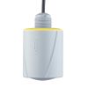
OTT RLS Radar Water Level Sensor
Features
- Transmit & receive antenna enclosed in a lightweight, durable housing with flat antenna design
- Easily mounts to a bridge, frame, pipeline, or extension arm
- Connects to NexSens X2 data logging system via SDI-12 interface
- Free ground shipping
- Expedited repair and warranty service
- Lifetime technical support
- More

Overview
The OTT RLS is a non-contact radar level sensor with pulse radar technology that is ideal for monitoring in remote areas and applications where conventional measuring systems are unsuitable. The RLS accurately and efficiently measures surface water level with a non-contact distance range of up to 115 feet above the water. The sensor is IP67 waterproof and has extremely low power consumption, making it ideal for solar-charged monitoring systems.
Revolutionary
The radar level sensor uses a revolutionary level measurement technology, meeting the USGS accuracy requirement of +/-0.01 feet. Two antennas are enclosed in a compact housing and transmit pulses toward the water surface. The time delay from transmission to receipt is proportional to the distance between the sensor and the water surface. A sampling rate of 16 Hz (16 measurements/second) with 20-second averaging minimizes water surface conditions such as waves and turbulence. The RLS does not require calibration and is unaffected by air temperature, humidity, flood events, floating debris, or contaminated water.
- (1) Radar level sensor
- (1) 2-part swivel mount
- (1) Installation kit - Includes (4) 6x40mm wood screws & (4) plastic plugs
- (2) Double open-ended wrenches (10x13)
- (1) Factory acceptance test certificate (FAT)
- (1) Operations manual
Select Options


In The News

Stone Lab: Cyanobacteria Monitoring in Ohio Lakes
Microcystin, one of several toxins produced by the cyanobacteria that form harmful algal blooms (HABs), has become a popular topic of lake research as the human health impacts of HABs become better understood. Stone Lab is one of the leading groups in algal bloom research on Lake Erie and other lakes in Ohio. For more than 100 years, Stone Lab has conducted biology research and provided science education and outreach to the region. Over the years, thousands of individuals of varying ages have learned from the resources Stone Lab provides. Stone Lab’s Research Coordinator and Senior Researcher, Justin Chaffin, learned of Stone Lab while an undergraduate student at Bowling Green State University Fireland Campus.
Read More
From Assessment to Angler: Continual Research Ensures Lake Erie Remains a Beacon of Freshwater Fishing
Lake Erie is well known for its abundant recreational fishing. Anglers come from across the country to try their luck at the “walleye capital of the world” and search for other freshwater species, such as bass, perch, and steelhead trout. As one of the world’s largest freshwater fisheries, much effort is made behind the scenes to maintain fishing opportunities for visitors to enjoy year after year, efforts that often go unnoticed by the public. One of the lake's most important economic and tourism centers is the city of Sandusky, home to the Sandusky Fisheries Research Station . As part of the Ohio Division of Wildlife, the unit serves as a base for assessing fish populations and managing harvest with partner agencies from around Lake Erie.
Read More
High Definition Stream Surveys: Informed Management in Local Waterways
When it comes to environmental monitoring, new stream survey methodologies have revealed a great deal about water quality and streambed conditions over time. Such information can be particularly important in leading restoration initiatives and prioritizing management decisions. Historically, stream surveys have been conducted at a single point along the stream, with data then extrapolated for miles up and downstream. However, Brett Connell, Hydrologist and Director of Sales at Trutta Environmental Solutions, started developing a more intensive stream survey format in his master's program in 2010 at the University of Tennessee.
Read More