- Home
- Eos Arrow Gold+ RTK GNSS Receiver
Eos Arrow Gold+ RTK GNSS Receiver
This item is currently on order from the manufacturer, but it has not yet arrived to our warehouse.
For a current estimate of availability, please call 888-426-2151 or or fill out the form below:
This item drop ships directly from the manufacturer, and the actual lead time is dependent on availability at their warehouse.
For a current estimate of availability, please call 888-426-2151 or or fill out the form below:
Fulfillment times may be longer than usual due to component shortages and other factors outside of our control.
For a current estimate of availability, please call 888-426-2151 or or fill out the form below:
Shipping, Delivery, Order Processing & Product Availability
Fondriest uses the best carriers to make sure orders get to you on time. Learn more about shipping times, methods, costs, and carriers.
Delivery Time
Shortly after you place your order, you will receive an Order Acknowledgement email to confirm your order details, including shipping and a delivery estimate. Once your order has been prepared for shipment and shipped, you will receive a Shipment Notification email with the carrier and tracking information.
Shipping and Delivery Estimates
The 'Ships' timeframe is an estimate of when the item will ship from our warehouse. All items will ship at one time unless you specifically request a partial shipment. In which case, the items on your order will ship as they become available.
The ‘Delivers’ timeframe is an estimate of when the item will be delivered. The estimated delivery time depends on the shipping method you choose during checkout. All estimates are based on business days.
Shipping Options
Fondriest offers several convenient shipping options via UPS.
| Ground Shipping: | Products shipped via ground service are typically delivered within five business days after shipment. |
| 2-Day Shipping: | For an additional charge, Fondriest offers 2-day shipping for most products. Products shipped via two-day service prior to 4:00 p.m. EST are usually delivered by 7:00 p.m. local time two business days after shipment. |
| Overnight Delivery: | For an additional charge, Fondriest offers overnight shipping for most products. Products shipped via overnight service prior to 4:00 p.m. EST are normally delivered by 7:00 p.m. local time one business day after shipment. Earlier overnight delivery options may also be available, depending on the destination. |
| Your Account: | For no additional charge, Fondriest can ship on third-party customer accounts via UPS and FedEx. Note that FedEx Ground shipments are picked up the following business day, and Express shipments must be made before 1:00 p.m. EST to ensure same-day pick-up. |
Remember that these estimates are for time in transit only and that they do not apply until the product leaves the Fondriest warehouse. As the delivery of your order is beyond Fondriest’s control once your order leaves the Fondriest warehouse, we cannot assume liability for late deliveries, regardless of the delivery method you specify.
Signature Required on Most Deliveries
Most of Fondriest’s shipments contain valuable equipment. If you will not be at the shipping address to accept delivery of your product, consider shipping the item to an address where someone you trust will be available to sign for your package, or accept your package if a signature is not required for the delivery.
Once your order has prepared for shipment or has shipped, we are unable to change the shipping address. Title and risk of loss to all products will pass to you on delivery. If you are willing to assume the risks of delivering your order without a signature, you may authorize Fondriest to arrange for a delivery that does not require anyone to be at the delivery address.
Undeliverable Packages
Occasionally, packages are returned to Fondriest as undeliverable. When the carrier returns an undeliverable package to Fondriest, please contact us to make arrangements for reshipment.
Failed Delivery Attempts
Most of Fondriest carriers make three attempts to deliver a package. After three delivery attempts, the carrier will return the package to Fondriest.
Order Processing
The estimated shipment date on your order is based on product availability, payment processing time, and warehouse processing time and does not include transit time. We do not begin payment processing until Fondriest receives all of the information that is needed and full payment or a full authorization, in the case of credit card or rental orders.
Fondriest will begin payment processing for orders placed on weekends or holidays on the next business day. Business days are Monday through Friday, excluding federal holidays.
Your order for in-stock items that are eligible for same-day shipping must be received before your local time of 2:00 p.m., pending payment processing, for there to be adequate remaining time in the day for your order to be dispatched.
Product Availability
Fondriest makes every effort to ship your product according to the estimated lead times. The estimated lead times are in business days (Monday through Friday, excluding federal holidays). Although Fondriest makes every effort to ship your order according to the lead time provided, shipping dates may change due to changes in supply. If the lead time changes, Fondriest will contact you via email and provide a revised shipping estimate.
Fondriest makes every effort to supply the products you order, but there may be occasions when Fondriest confirms orders and later learns that it cannot supply the products, either at all or in the quantities ordered. Although rare, these occasions can include when Fondriest learns that the products are no longer being manufactured or they otherwise become unavailable, when Fondriest cannot source components for the configuration you ordered, or when there was a pricing error at the Fondriest Online Store.
In those circumstances, Fondriest will inform you and, if you are interested, Fondriest may suggest alternative products that may meet your needs. If you do not wish to order alternative products, Fondriest will cancel your order for products that cannot be supplied and for any other products that you no longer wish to order as a result, and will issue a refund.
If you are not completely satisfied with your purchase, you may initiate a return within 30 calendar days of receiving your item(s). To begin a return, you must request a Return Material Authorization (RMA) by either contacting your account representative or the general customer support address: customercare@fondriest.com.
Returns without an RMA will not be accepted.
Items returned for credit must be new, unused, and in the original packaging (including any accessories, manuals, and documentation that shipped with the product). Returned items must be received by Fondriest Environmental within 14 calendar days of the issuance of the RMA.
All returned items are subject to inspection and approval prior to the issuance of any credit. If the returned items have been approved, Fondriest will issue a credit based on the original method of payment. Please note that items may be subject to a manufacturer’s restocking fee.
Non-Returnable Items: Fondriest does not permit the return of or offer refunds for the following products:
- Configured-to-order or customized products
- Hazardous materials
- Opened calibration reagents
- Opened software
- Software downloads
- Fondriest Gift Cards
Fondriest recommends using a carrier that offers shipment tracking for all returns. Packages should be insured for the full value in case of loss or damage. Fondriest does not assume any liability for loss or damage to the product during shipping.
- Free ground shipping
- Expedited repair and warranty service
- Lifetime technical support
- More
At Fondriest, we are committed to providing high-quality products at affordable prices with the industry's best support. Additionally, we offer:
-
Discounts
High volume purchases lead to favorable pricing, which is passed on to the customer by way of discount off MSRP.
-
Assembly, Test and Calibration
Sensors and instruments are assembled, tested and calibrated prior to shipment. A calibration report is included.
-
Lifetime Technical Support
A knowledgeable staff of applications engineers provides ongoing support for the life of the product.
-
Product Training
Applications engineers are available for webinars or personalized, on-site startup and training. Extensive measurement technology, product troubleshooting and instrument repair workshops are offered at the Field Station.
-
Extended Warranties
Warranties extended beyond factory standards are offered on many items to ensure a lasting useful life.
-
Repair
A factory-authorized service center provides fast turnaround product repair and annual maintenance.
-
Rental
Rental equipment is available to minimize downtime and cover equipment needs when projects expand.
-
Communications
Call, email or chat online with applications engineers. Email correspondence is responsive and a toll-free number is available for added convenience.
-
Quick Ship
Many orders ship on the same day and expedited shipping is available. If a product cannot be shipped immediately, customers are notified by phone or email.
-
Discounts
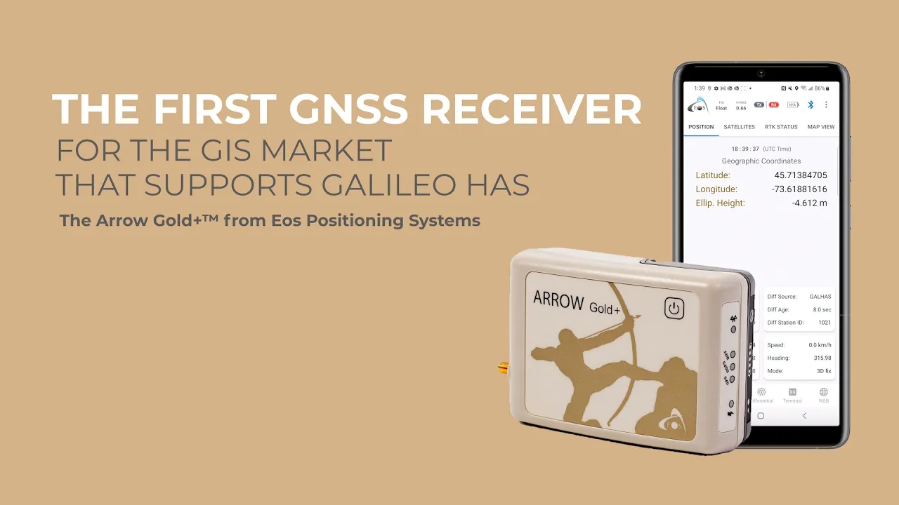
- Supports GPS, GLONASS, Galileo, BeiDou, and more
- 100% Android, iOS, Windows compatible
- 1cm RTK real-time accuracy
The Arrow Gold+ is the first high-accuracy Bluetooth GNSS receiver on the market to implement all four global GNSS constellations (GPS, GLONASS, Galileo, BeiDou), all available frequencies, and satellite-based RTK augmentation on any iOS, Android, and Windows devices. Moreover, this GNSS receiver has full-band support for all GNSS signals including Galileo High-Accuracy Service (HAS). The Arrow Gold+ works with all off-the-shelf mobile apps.
The Arrow Gold+ includes all the same features of the now-retired Arrow Gold GNSS receiver, with additional ones. The Arrow Gold+ offers 800+ channels (compared to 394 with the Arrow Gold), also includes support for additional GNSS signals, India’s IRNSS (L5), longer battery life, built-in functionality of the Eos Bridge Bluetooth connector, and the ability to connect multiple mobile devices to one receiver. This is the most future proof, ubiquitous, and productive Arrow Series GNSS receiver that Eos Positioning Systems offers.
- (1) Arrow Gold+ receiver with USB & Serial ports
- (1) Arrow Smart Battery Pack
- (1) L1/L2/L5 / LBand Precision Antenna
- (1) Large Antenna Mounting Plate
- (1) Two-section Short Antenna Cable for survey pole
- (1) Arrow Pole Mount Bracket
- (1) Range Pole Clamp
- (1) USB Data Cable
- (1) 12V International Power Supply for Arrow Smart Battery pack
- (1) Hard Shell Case
Select Options


have been added to your cart
There are items in your cart.
Cart Subtotal: $xxx.xx
We can't add this item to your shopping cart right now. Please reload the page.
Please first select the items and quantities to add to your Cart.


Customer Stories

Restoring a California Creek Enhances Salmonid Habitat in Redwood Forests
In Northern California’s coastal forests, massive redwoods tower over their surroundings. Crossing between these behemoths are countless streams that snake through the forest, emptying into larger rivers and eventually the Pacific Ocean. These waterways are crucial for salmon, which traverse upstream to their historic spawning grounds. However, human pressures have long hindered these upstream migrations. Large dams on major rivers are usually the culprit and receive significant attention when they’re removed, celebrated for releasing sediment buildup and providing upstream access . But sometimes salmon must travel far into the watershed, reaching smaller streams in the heart of forests.

NexSens Buoys Monitoring Floating Offshore Liquid Natural Gas Terminals in Ravenna, Italy
A new floating liquid natural gas terminal in Italy’s Adriatic Sea is making waves for the country’s energy independence. The platform was funded by Snam in 2022 as a way of boosting domestic energy production in the wake of global concerns over foreign energy reliance. Deployed off the coast of Ravenna, Italy, the floating platform was built in order to create a hub for LNG transfer from ships to land via an underwater pipe from the terminal. “The idea is that vessels can come in and offload liquefied natural gas offshore,” states Shawn Hinz, managing partner at Gravity Consulting LLC and managing scientist for the project.

Restoring the Headwaters of Ohio’s Most Biodiverse River, the Big Darby Creek
The Big and Little Darby Creeks meander over 80 miles through rolling hills of corn fields and sparsely populated towns east of Columbus, Ohio. The creeks were federally designated as a National Scenic River in 1994 and harbor some of the Midwest’s most impressive aquatic and riparian biodiversity. According to the Ohio Department of Natural Resources (ODNR), this includes 100 species of fish, five of which are state endangered, and 45 mollusks, eight of which are federally listed. These impressive natural resources have attracted not only local and federal protection but also the interest of conservation organizations.