
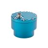
Geolux Non-Contact Flow Sensors
Features
- Contactless water level and surface velocity measurement
- Integrated discharge (flow) calculation
- RS-232, RS-485 Modbus, SDI-12, analog 4-20 mA interfaces in all models
- Free ground shipping
- Expedited repair and warranty service
- Lifetime technical support
- More
Oerview
The Geolux Non-Contact Flow Sensor has an integrated radar surface velocity and level sensor for contactless velocity, level, and discharge (flow) measurements.
Mechanics
Contactless radar technology enables quick and simple sensor installation above the water surface with minimum maintenance. Calculation of the total flow discharge is internally implemented within the instrument by combining surface velocity measurement, water level measurement, and a configured cross-section of the river or channel. Defining the measurement parameters such as profile cross-section, material of the edges, location of the sensor above the water, and all other instrument settings can be easily set with the Geolux configuration application using any available communication interface.
General Specifications
Detection Distance: 15m / 30m / 50m
Speed Range: 0.02m/s to 15m/s
Speed Resolution: 0.001m/s
Speed Accuracy: 1%
Level Resolution: 0.5mm
Level Accuracy: +/-2mm
IP Rating: IP68
Electrical & Mechanical
Input Voltage: 9 to 27 VDC
Power Consumption: 1,3 W operational; 0,235 W standby
Maximal Current: < 750 mA
Temperature Range: -40 °C to +85 °C (without heating or coolers)
Enclosure Dimensions: 150mm x 200mm x 250mm
Weight: 3.08kg
Interface
Serial Interface: 1 x serial RS-485 half-duplex; 1 x serial RS-232 (two wire interface)
Baud Rate: 9600 bps to 115200 bps
Serial Protocols: Modbus, GLX-NMEA
Other Protocols: SDI-12
Analog Output: 4-20 mA, programmable velocity, level or flow
Certificates
EN 61326-1:2013
ETSI EN 301 489-1
ETSI EN 301 489-3
EN 301 489-3 V2.1.1:2019
EN 301 489-1 V2.2.3:2019
EN 300 440 V2.2.1:2018
EN 62368-1:2014+A11:2007;
EN 60950-22:2017
EN 61010-1:2010
FCC Part 15 class B
ISED RSS211
Select Options


In The News

Wildfire Prevention in the Sierra Nevada Region with the Yuba Watershed Institute
Though recent wildfires have sparked new conversations about wildfire management and response, groups like the Yuba Watershed Institute have been monitoring the forests and water resources of the Sierra Nevada region for decades, managing approximately 5,000 acres of land with the Bureau of Land Management (BLM) and about 7,000 acres in private land partnerships. The goal of the Institute is to work with local communities and land agencies to improve watershed and forestry management through informed practices and public outreach. The goals of the Yuba Watershed Institute are three-fold: Improve the ability of fire suppression agencies like the California Department of Forestry and Fire Protection ( CAL FIRE ) and the US Forest Service.
Read More
Wave Sensors Integration with NexSens Buoys: A Cutting-Edge Solution for Wave Measurment
Real-time wave data supports accurate weather prediction, safe and efficient maritime operations, and provides valuable safety and operating condition information for recreation and commercial fishing. Understanding wave dynamics also helps with the design of protective coastal structures like seawalls, breakwaters, and jetties. It also supports better prediction of their impact on sediment transport and coastal geomorphology. Wave data is a key factor in qualifying and designing offshore wind farms and harnessing kinetic energy for electrical generation. It helps with the understanding of ocean-atmosphere interactions and contributes to studies of sea-level rise and climate change impacts.
Read More
Spring 2025 Environmental Monitor Available Now
In the Spring 2025 edition of the Environmental Monitor, we highlight partnerships across the world and the importance of collaboration between government agencies, universities, environmental groups, local communities, and other stakeholders. From great white shark research in Cape Cod to monitoring fisheries in Lake Erie, this latest edition underscores partnerships that connect stakeholders in a watershed through environmental data. With an emphasis on data sharing, a combination of real-time and discrete sampling keeps the public and partners informed of environmental conditions. Our writers also sought out science professionals dedicated to working with peers within and outside of the environmental sector.
Read More