
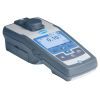
Geotech Portable Turbidity Meter
The Geotech Portable Turbidity Meter is designed to withstand the rigor of field analysis with laboratory precision and repeatability.
Features
- White light source meets EPA Method 180.1
- Shockproof, waterproof, and floats in water - even with the lid open
- Integrated data logger stores up to 1000 data sets
- Free ground shipping
- Expedited repair and warranty service
- Lifetime technical support
- More
Overview
The Geotech Portable Turbidity Meter is an extremely robust portable/laboratory instrument. Data points from field sample events can be stored in memory and transferred to a computer or other storage devices. Provides fluid clarity insight by shining light onto a sample and measuring the amount of light scattered by suspended particles in the fluid.
Included in Kit
- Turbidity Meter
- Economy Case with Custom Cut Foam (pictured above)
- 4 Primary Calibration Standards: 0.10, 20, 100, 800 NTU
- Lint-Free Cloth
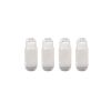
- 2 Sample Vials
- 4 AA Batteries
- (1) Turbidity meter
- (1) Case with custom cut foam
- (4) Primary calibration standards: 0.10, 20, 100, 800 NTU
- (1) Lint-free cloth
- (2) Sample vials
- (4) AA batteries
Select Options


In The News

Three Decades of Research at Acton Lake
A multi-disciplinary team at Miami University, Ohio, has been studying the environmental change at Acton Lake for over three decades. Using three different NexSens buoys over this time, the team has an incredible archive of data that is helping build a picture of Acton’s past, present, and future. Until recently, a NexSens CB-50 buoy was used alongside other environmental monitoring at Acton Lake. In May 2025, the Miami team deployed a new XB-200 buoy , future-proofing their ongoing monitoring using real-time buoy systems. Acton Lake, a small hypereutrophic reservoir in southwest Ohio, covers 2.4km² and has a maximum depth of about 8m. The dam was built in 1956, and the lake has a large agricultural watershed.
Read More
Source Water Monitoring in Albany, New York: Tracing Water Quality throughout Tributaries
Thousands of US cities pull their drinking water from natural source waters like reservoirs, rivers, and streams, making overall watershed health a key consideration for water providers. In Albany, New York, the Albany Department of Water and Water Supply delivers drinking water to over 100,000 residents as well as monitors and manages the larger drinking water supply watershed. Hannah Doherty, Environmental Specialist at the Albany Department of Water and Water Supply , spends her days working with a small team to monitor the drinking supply and the connected water bodies. Doherty explains, “We’re the first to encounter the water that ends up being the drinking water.
Read More
Wildfire Prevention in the Sierra Nevada Region with the Yuba Watershed Institute
Though recent wildfires have sparked new conversations about wildfire management and response, groups like the Yuba Watershed Institute have been monitoring the forests and water resources of the Sierra Nevada region for decades, managing approximately 5,000 acres of land with the Bureau of Land Management (BLM) and about 7,000 acres in private land partnerships. The goal of the Institute is to work with local communities and land agencies to improve watershed and forestry management through informed practices and public outreach. The goals of the Yuba Watershed Institute are three-fold: Improve the ability of fire suppression agencies like the California Department of Forestry and Fire Protection ( CAL FIRE ) and the US Forest Service.
Read More