Scientists in California are Blazing New Trails in Fire Weather Research
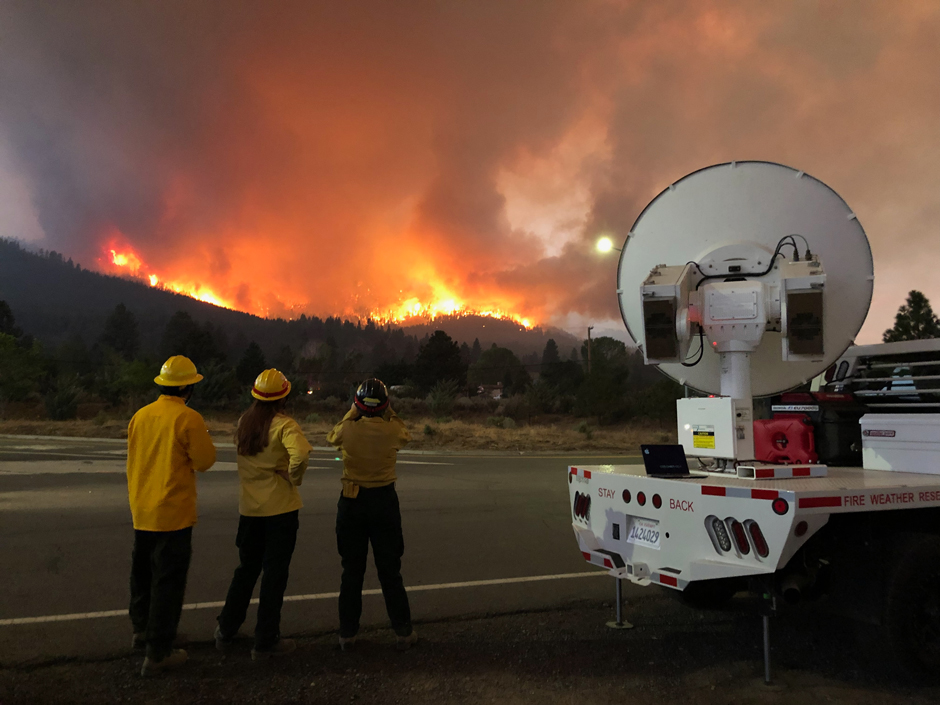
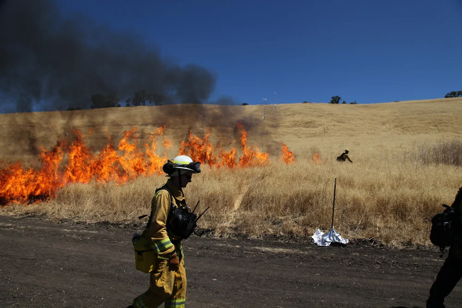
Craig Clements hears the news: A wildfire has broken out around the California Bay Area. He quickly makes his way to the Duncan Hall of Science at San José State University, home of the Wildfire Interdisciplinary Research Center (WIRC).
He hops into the cab of a white Ford F-250, but this is no ordinary truck. The normal truck bed has been mounted with measurement tools that can survey wildfires and their plumes up close.
And that’s exactly what Clements, a professor of meteorology and climate science and the director of the WIRC, plans to do: drive directly toward an active wildfire and study it.
He’s not storm chasing; he’s fire chasing.
Clements and his team of scientists, students included, have gone through these motions 50 times in the last twelve years. Clements says that’s the most deployments to active fires of any meteorology research team in the world.
This daring research technique has pioneered gathering data on fire weather and behavior, gathering real-world data that controlled studies simply can’t replicate.
This work has been decades in the making, and Clements himself has taken the field of studying fire weather to new heights.
But behind it all are some simple motivations: a thirst for data that can explain and predict the natural world, and a deep fascination with a relatively understudied but extremely consequential natural phenomenon.
San José State researchers deploy Doppler radar at the Dixie Fire in Northern California. (Credit: Craig Clements)
What is Fire Weather?
Fire weather encompasses the terrestrial and atmospheric conditions that can lead to a fire, but also how large wildfires can create their own weather.
When Clements came across this twenty years ago during his Ph.D. at the University of Houston, experimental observations were still a new field. But after running some baseline fire weather experiments, Clements was fascinated, and it’s been the core of his work since then.
“My research is looking at how fires generate their [own] weather,” Clements says, “and that’s where fires can actually cause the wind to shift kilometers away from the fire itself.”
It’s well known what conditions may lead to wildfires: Hot, dry, and windy conditions with plenty of dry fuel, often in the form of grasses or trees. But fires aren’t just a product of meteorological conditions; they’re also a driver of them.
Clements explains that a fire plume, which is the towering column of hot gases, smoke, ash, and debris that rises from a fire, interacts extensively with the atmosphere.
The plumes can punch into the lower stratosphere, form clouds, and that hot air can create vortices and updrafts that shift winds miles away.
“Those fire-induced winds can actually change the fire behavior, where it goes, also how it generates the clouds, the pyrocumulus and pyrocumulunimbus,” Clements explains.
But understanding fire weather hasn’t been easy. Gathering data on active fires requires mobile equipment and sensors, and a willingness to get up close with the blaze.
Luckily, Clements and the team he’s built at the WIRC, and the associated Fire Weather Research Laboratory, have no problem doing just that.
Ka-band Doppler radar scans a large prescribed fire in Fishlake National Forest, Utah, 2019. (Credit: provided by the Fire Weather Research Laboratory)
How Clements Pioneered Wildfire Field Research and Data Collection
Clements says that people have chased storms like hurricanes and tornadoes for decades, but “chasing fires” has only started in the 21st century. Even then, most who were trying to study active fires were content to use satellites or fly above plumes to collect data.
“Nobody’s really gone on the ground and looked at vortices and the fire, how the winds are structured, and got up close observation, so that was cutting edge,” Clements says. “The big thing was how to deploy meteorological instrumentation to active wildfires.”
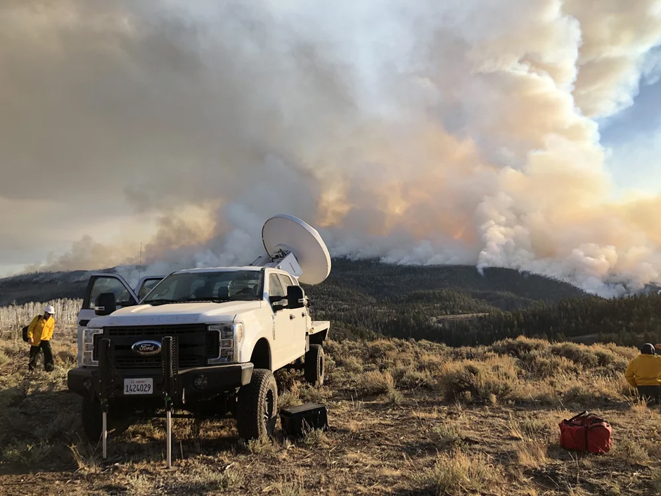
Doppler Lidar and Radar are common methods for tracking and visualizing wind patterns. However, these instruments are usually large and bolted in place.
To get around this problem, Clements needed mobile instruments. That’s how the sensor-mounted pickup trucks were born, allowing the team to take their instruments on the road.
One truck has a Ka-band Doppler Radar mounted on the bed, used for measuring plumes. Another truck is outfitted with a suite of instruments, consisting of a Doppler Lidar, a temperature and humidity profiler, a sounding system, and a meteorological station.
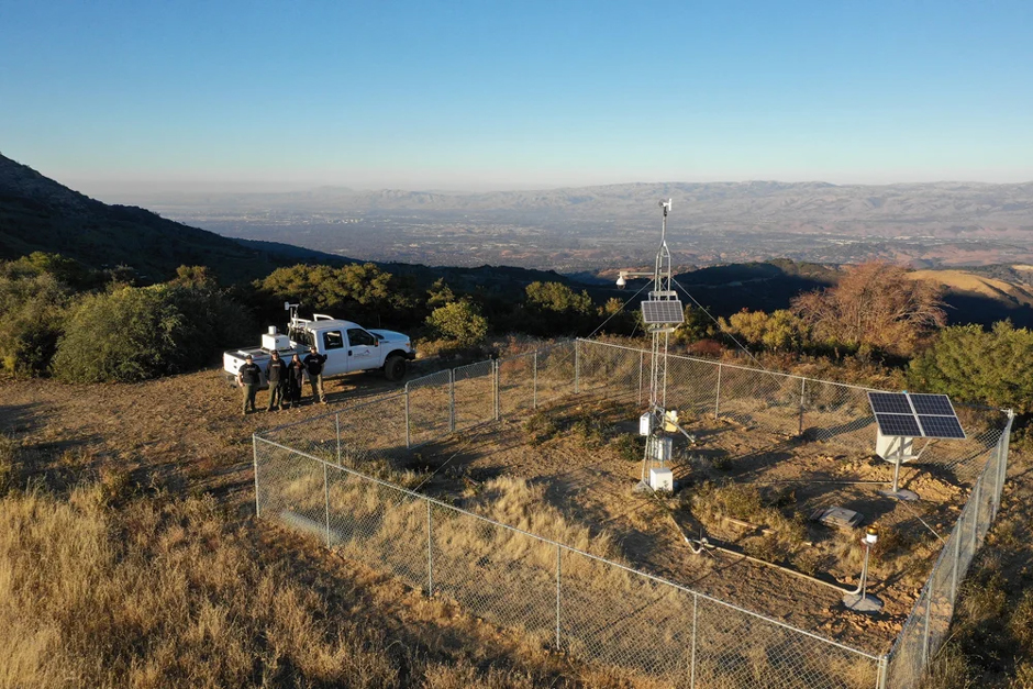
SJSU’s Fire Weather Research Laboratory’s remote automated weather station and fuel sampling field site, Santa Cruz Mountains, Santa Clara County, CA. (Credit: provided by the Fire Weather Research Laboratory)
“[We’ve] measured plume structures and velocity wind fields around fires,” Clements says. “And we’ve measured the cloud tops. We learned a lot about the depth of the fire-induced winds, their extent, and also getting really nice plume structures, understanding how the winds and the plume are evolving.”
With instruments right next to the wildfires, Clements says he and his team can gather data in near-real time.
The instruments can be connected to computers, and the team can obtain visual profiles of wind behavior and plume shape in just a few seconds, providing a more accurate picture of a wildfire than stationary sensor equipment.
But Clements doesn’t rely solely on these field measurements, as the WIRC also has a system of over a dozen surface weather stations throughout the Bay Area.
These systems are outfitted with meteorological instruments to measure winds, temperature, humidity, precipitation, fuel moisture, and weather stations, soil moisture sensors, radiation sensors, and more. Another network is the California Fire Weather Profiling Network, which includes three Doppler Lidar stations, providing wind profiles across Northern California.
“These networks are used to understand the baseline fire weather conditions and provide context for the season and for general fire danger,” Clements says.
Some stations are part of the national Remote Automatic Weather Stations, while Clements says others are used for research purposes. The long-term data is stored and processed, which Clements uses to contextualize the active fires they arrive at.
But the WIRC doesn’t simply keep these pioneering methods and datasets to itself; Clements and his team work with a range of external partners to send their data out into the world.
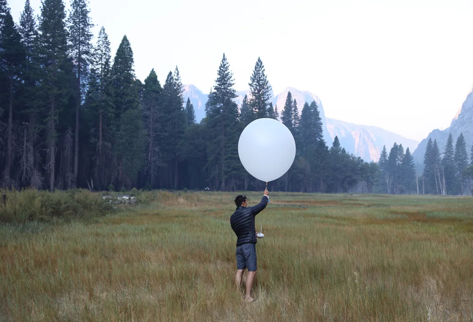
Weather balloon launch in Yosemite Valley, CA, during the Rim Fire, 2013. (Credit: provided by the Fire Weather Research Laboratory)
Using Wildfire Data to Validate Forecasting Models
Weather forecasts are widespread and often used daily by people around the world. These forecasts are made by models that are filled with real-time and real-world data, and for decades, storm chasers have provided data for tornado or hurricane forecasts.
While these models aren’t perfect, Clements says they benefit from much more data than fire models have.
Although modern wildfire modeling benefits from extremely advanced computational programs, such as coupled fire-atmosphere models, they lack validation from real-world data.
“I leverage the research because we’re able to forecast these processes now with very high resolution, [like] coupled fire-atmosphere models, but we don’t have those data to validate those models,” Clements says.
Refining these models so that government agencies, municipalities, and utilities can better forecast wildfire behavior is at the core of Clements and the WIRC’s work.
Clements says that within the center, they have a number of their own fire forecast tools, including cloud dynamics and an internationally renowned coupled fire atmosphere model called WRF-SFIRE.
An experimental fire conducted in Central California, Fort Hunter-Liggett, to study fire behavior on slopes. (Credit: provided by the Fire Weather Research Laboratory)
Sharing Wildfire Models and Research with the Public
San Jose State University (SJSU) and the WIRC’s wildfire knowledge are known across the country, and agencies like the US Forest Service and NASA use their models and data, whether to monitor a fire on their property or for large-scale research.
“People will say, ‘Hey there’s this big fire. Are you guys simulating it?’” Clements explains. “Because they really want to know where the smoke goes, or really want to know where it’s going to burn.”
Local utilities companies, some of whom pay into the WIRC for access to their new research, also utilize the center’s forecasting tools to validate their own models. Clements says that sometimes the WIRC creates tools and products specifically for these members, and that many of his graduate students have gone to work in the private sector.
When Clements started a fire weather lab at SJSU in 2007, he had little idea how large it would become and how many people it would impact. His graduate student and staff numbers have grown, and he’s even seeing undergraduate students coming to SJSU specifically to study fire weather, which he sees as growing recognition about this viral research niche.
Ultimately, Clements and his team’s trailblazing research is changing how some of nature’s most powerful natural disasters are understood and forecasted.
“That’s how it ties back to society, is creating the next generation forecast products, risk models, or risk maps for a region, for communities, or for [states],” Clements says, “And it all leverages back to getting the right data to understand the phenomena so we can forecast it.”


0 comments