Reconnecting a Columbia River Tributary is Restoring Salmon and Water Quality
In 1854, the United States’ Government Land Office sent surveyors across the Great Plains to the wild border between the Washington and Oregon territories. It was here that they came across the East Fork Lewis River, which tumbles down from the Cascade Mountain Range before emptying into the Columbia River and, eventually, the Pacific Ocean.
The surveyors found a lush, green forested wetland with a calm river that braided widely across the landscape. After rapidly losing elevation from its headwaters in the Gifford Pinchot National Forest, the river’s velocity was absorbed by the wide floodplain. Meanwhile, the interlocking side channels formed a well-connected system and gravel deposits that were ideal salmon spawning habitat.
But these salmon-friendly gravel deposits would soon cause problems.
Several decades later, as Clark County — through which the river flows — expanded, gravel mines began crowding the banks of the East Fork Lewis River. These operations quickly drained the side channels and gutted the floodplain, removing over one million cubic yards of gravel and constricting the river into a single channel constrained by levees and berms
These landscape changes resulted in the simultaneous loss of salmon habitat and increased bank erosion. Now, nearly 200 years after the river was first mapped, a $23.5 million project aims to reconnect and restore a stretch of the East Fork Lewis River to its former self.
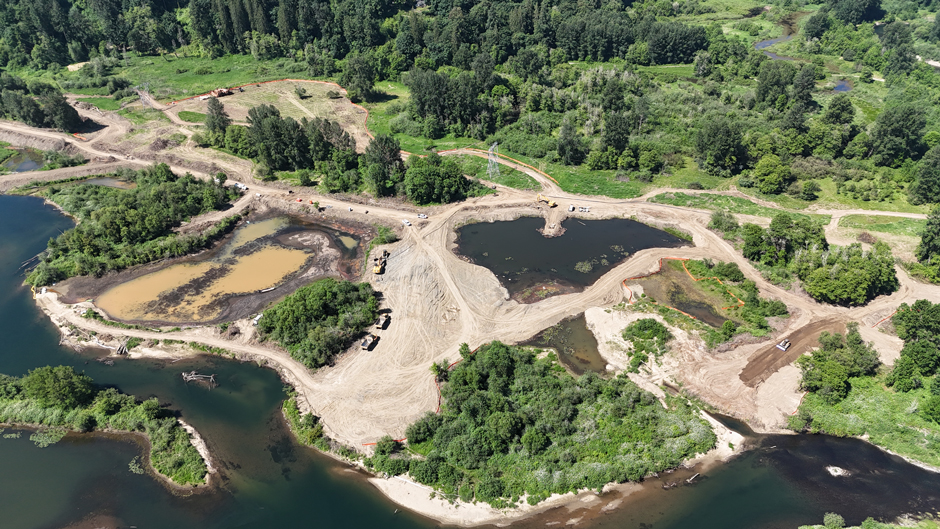
Several gravel pits before floodplain restoration. (Credit: Tapani Inc.)
How River Reconnection Benefits Salmon and People
In 1996, a 100-year flood event caused the river to burst through an abandoned gravel mine’s levee. This shifted the river’s flow away from the main channel. This caused a stretch of the river just north of Portland to house a “series of stagnant, deep water ponds.” The main channel now flows through these pools, disconnected from the historic floodplain.
The local community realized these geomorphic changes were severely degrading the river. Anglers noticed salmon numbers decreasing, and homeowners were becoming wary of intense erosion. Over the past few decades, momentum has been building to restore the East Fork Lewis River.
In April 2025, the Lower Columbia Estuary Partnership broke ground for the East Fork Lewis River Reconnection Project. Kari Dupler, a Principal Restoration Ecologist for the Estuary Partnership, says that the project will restore a three-mile stretch of the river around the gravel mines to its historical braided shape.
“Re-establishment of a multi-threaded channel network and reconnection of the floodplain to those channels will create spatially diverse areas of geomorphic and habitat complexity, [create] areas with hyporheic flow, and will aid re-establishment of native riparian vegetation,” she explains.
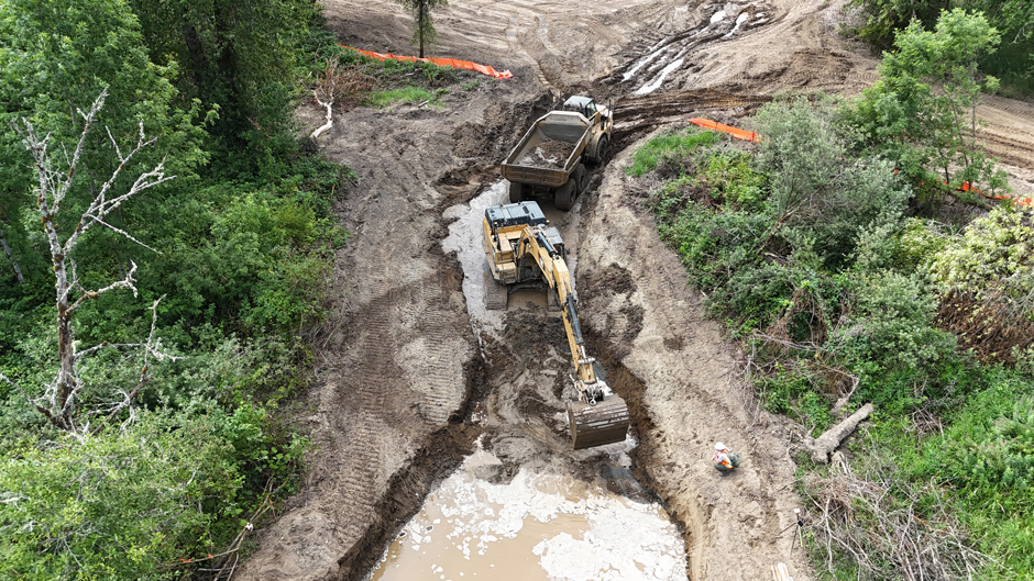
Constructing Dyer Creek, a tributary to the East Fork Lewis River, to reconnect surface water flows to allow fish access into off-channel habitats. (Credit: Tapani Inc.)
According to Public and Legislative Affairs Manager Jasmine Zimmer-Stucky, the project’s beneficiaries include wildlife, plants, and humans alike.
Salmon swimming upstream from the Columbia River find it difficult to traverse this stretch and reach their historic spawning grounds. As the river moves through gravel pits, the water slows and warms, creating a temperature barrier for cold-loving salmon.
Even the salmon that make it to their spawning grounds leave their offspring in a dire situation. Non-native species like smallmouth bass, which prefer warmer water, have proliferated here, preying on juvenile salmon.
“Whenever the juvenile salmon were swimming downstream to get to the ocean, they would have faced this massive gauntlet of fish that were trying to feed on them,” Zimmer-Stucky explains.
Moreover, channels that connect to the river’s floodplain offer more nutrients, habitat, and better temperatures for salmon, whether they’re returning to their spawning ground or juveniles preparing to journey to the ocean.
“Reconnecting the river to its floodplain allows floodwaters to soak into the ground, recharging groundwater reserves,” Dupler says. “In an area like this reach of the East Fork, this cold groundwater seeps back into the river during summer months when water levels in the river are low, and surface water temperatures are higher, creating a cold water refuge for fish.”
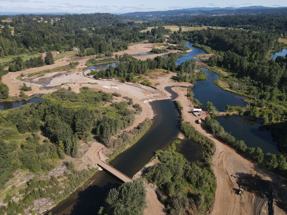
A temporary diversion dam was built to relocate the flow of the East Fork Lewis River during the summer of 2025 so construction crews could reclaim the gravel pits and restore the river. (Credit: Lower Columbia Estuary Partnership)
Beyond these pools, the river is bottlenecked into a single channel. Losing the braided channels has forced the East Fork Lewis River’s entire velocity in a singular direction.
Over the course of decades, this has caused the forceful river to heavily erode some of its banks. Once the river descends from the Cascades, it passes through more urbanized areas with houses and buildings closeby, which Zimmer-Stucky says has worried landowners.
“Anytime you’ve got fast-moving water in a small, narrow system, it’s going to erode the side of the banks,” she says. “So what we’re trying to do is give the river more room to spread out, so that it lowers the velocity.”
Therefore, Zimmer-Stucky says the project has garnered lots of support from the local community. They’ve helped bring back local flora by planting native vegetation along the river’s restored shores.
But native planting is only one part of the reconnection project, which must first physically transform the river itself.
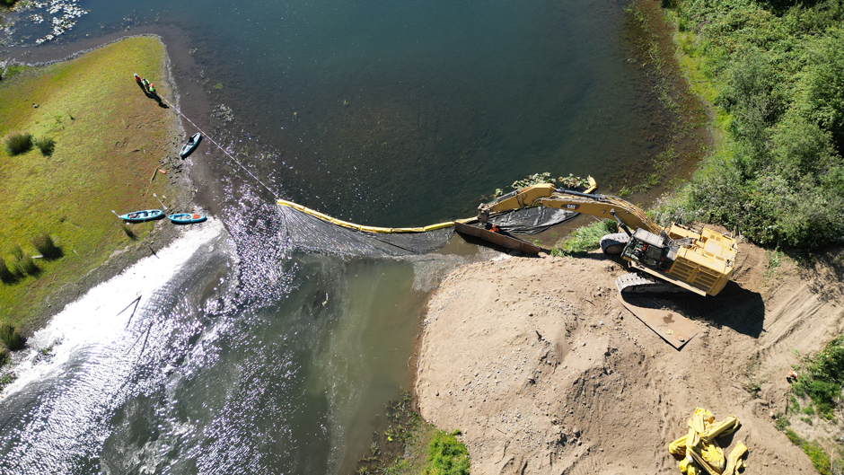
The construction crew places a block net and turbidity curtain to protect water quality and keep aquatic species out of a gravel pit prior to restoration. (Credit: Lower Columbia Estuary Partnership)
Reconstructing a River Ecosystem
For the last several years, Clark County, where the project is located, has been buying land along the river for conservation purposes. These include the abandoned gravel mines, which are being filled and restored with native vegetation. Zimmer-Stucky says that local volunteers have already planted thousands of natives into banks formerly overrun by non-natives.
Ultimately, the project is restoring the historically braided river system and wide floodplain. Therefore, the Estuary Partnership, with funds from the Washington Department of Ecology, Washington Recreation and Conservation Office, and NOAA are completely reconstructing this stretch of the river.
The construction has been contracted to the local company Tapani, Inc., who are using heavy machinery to excavate new channels along the main river. Zimmer-Stucky says they are a local company, which contributes to the project’s sense of community input.
The local connection that construction crew members bring to the site each day creates a strong sense of community and commitment to the project,” she says.
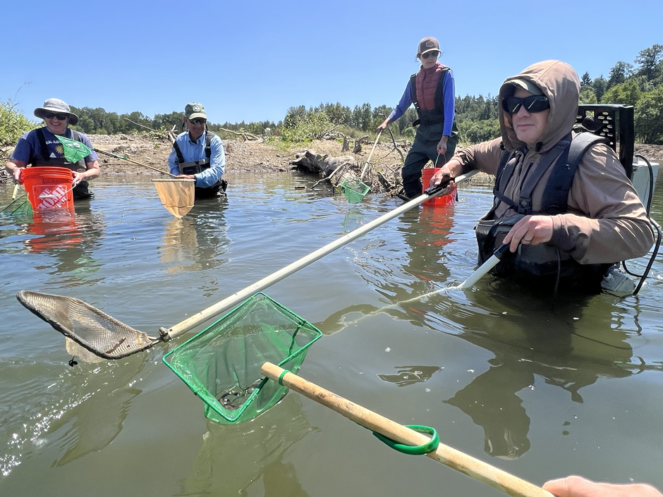
Before construction crews could begin restoring the East Fork Lewis River, aquatic species like lamprey, mussels, painted turtles, and fish had to be captured and relocated safely outside of the project area. In this photo, people are capturing juvenile lamprey. (Credit: Lower Columbia Estuary Partnership)
For several months, fish within the project zone were relocated to minimize adverse impacts on wildlife. The project will also install large woody debris in the river to create more wildlife habitat once they return, and replace an undersized culvert at the outlet of a wetland to improve riparian flow.
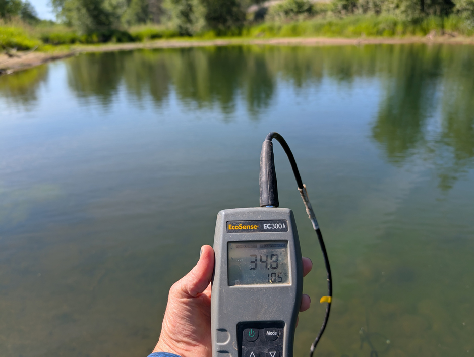
Amid temporary construction pressures, Dupler says river temperature and turbidity are monitored daily using a YSI EcoSense 300A and a Hach 2100Q Portable Turbidimeter, respectively.
Braiding and connecting new channels along a three-mile stretch of river is an intensive undertaking. Yet, Zimmer-Stucky says the large funding pool and adjacent country land have eased external pressures.
“We know that [there are] trucks on the road, and there’s some closures, and some other local, temporary inconveniences,” she says, “but we work really hard to make sure that we bring people into the restoration project so that they see the long-term benefit.”
Water temperature in a gravel pit that is now being restored. (Credit: Lower Columbia Estuary Partnership)
Monitoring the East Fork Lewis River’s Future
The reconnection project aims to finish construction in October of 2026. Dupler says that the Estuary Partnership and its partners will conduct post-restoration monitoring based on their project goals.
“We’re monitoring how this stretch of river develops over time, new channel alignments, sediment deposition, vegetation re-establishment, and wetland development,” Dupler says.
The Estuary Partnership will monitor several indicators of a successful restoration, including groundwater level in newly constructed areas, and native plant establishment.
Dupler says they’ll also monitor the new channel alignment to track sediment deposition and water flow, ensuring the newly braided East Fork is truly returning to its former shape.
“Our hypothesis is that project actions will reduce water temperatures in specific locations due to increased interactions between groundwater and surface water, increased hyporheic flow, and shading,” Dupler says.
According to the restoration project website, salmon are once again spawning in the created and restored river sections, and wildlife like beavers have been spotted. Once construction is completed, the Washington Dept of Fish and Wildlife will monitor the three-mile stretch for salmon nests.
Ultimately, Zimmer-Stucky has appreciated the buy-in from their communities and partners to improve the East Fork. She says the Clark County land will be opened to the public once the project is complete, so that anyone in the area can enjoy the river in its natural form.
“A river access site adds to the public’s opportunities,” she says. “So that’s another really key benefit.”


0 comments