From Source to Sea: Monitoring and Protecting Santa Barbara’s Hidden Creeks
The city of Santa Barbara, California, is known as the “American Riviera,” sporting a sandy coastline, warm and sunny climate, and classic Spanish Architecture. Tucked in between the Pacific Ocean to the south and the Santa Ynez Mountains to the north, it’s a city shaped by nature.
Many tourists come to this area of Southern California for its well-known beaches, and others to hike through the coastal mountains. However, another natural feature defines Santa Barbara, one that locals and tourists often overlook amid the other vibrant attractions in this beach town.
Four major creeks arise in the mountains to the north and slice through the city before emptying into the ocean: Arroyo Burro Creek, Laguna Channel, Mission Creek, and Sycamore Creek. Their estuaries are at popular beaches, but they run right through some of Santa Barbara’s most densely populated areas.
The City of Santa Barbara’s Creeks Division is in charge of monitoring these creeks, whose watersheds cover tens of thousands of acres within and outside city limits. Urbanization has increased impervious surfaces within their watersheds and led to fully impervious creek banks in some locations, causing increased stormwater runoff and harmful pollution entering these waterbodies.
Therefore, the Creeks Division must split its time monitoring these creeks to ensure they remain safe, while simultaneously working to safeguard their watersheds from further damage.
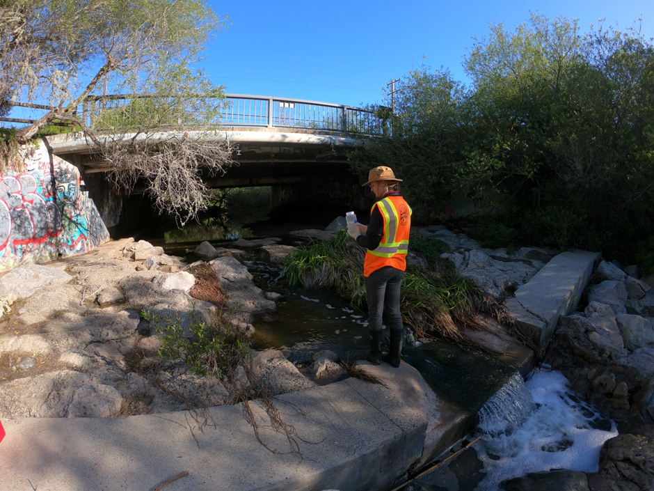
Shepherd samples for bacteria as part of the Creeks Division’s biweekly sampling protocol on Arroyo Burro Creek at Cliff Drive. (Credit: Laurie Van De Werfhorst)
Why Santa Barbara Needs Water Quality Monitoring
Caroline Shepherd is an assistant planner in Santa Barbara’s Creeks Division. After working on wetland restoration in college, she earned her master’s from UC Santa Barbara before working with the city. She sees her role as helping communities “restore and protect their watersheds.”
Shepherd spends half her time actively monitoring the city’s four creeks and the other half reviewing projects, construction, and restorations for their impact on the watersheds. Her monitoring takes her into the field, where she can keep a pulse on the water quality of Santa Barbara’s waterways.
While most of the creeks don’t originate in the city, they face the most water quality pressure when snaking through the urban area. This pressure is also felt by the wildlife that uses the creeks for habitat.
“The hardening of creek banks really impacts critters that would normally live in the rocks and substrate of a natural creek,” Shepherd says. “There’s simply no place for them to live in a concrete creek.”
This creates an ecological cascade that leads to the loss of fish, birds, and vegetation, further reducing the natural state of the creeks and their ability to filter pollutants.
Moreover, as a coastal city, whatever runoff enters the creeks also enters the ocean, which draws millions of visitors each year, and means these creeks must be carefully watched.
“We want to catch issues anywhere in the stream before they get to the ocean,” Shepherd explains.
She uses a YSI ProDSS to measure temperature, electrical conductivity, pH, dissolved oxygen, and turbidity, all indicators of a waterbody’s health. Unsurprisingly, the creeks show telltale signs of poor water quality from urban runoff, as they’ve all had impervious concrete or other surfaces added to their banks within city limits.
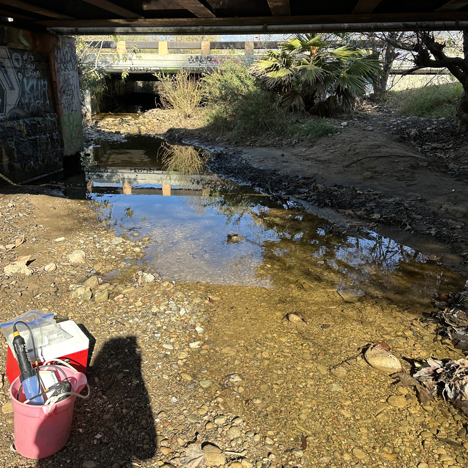
Sycamore Creek under a railroad bridge. This creek often runs dry in the summer months. In the bottom left, you can see the Creeks Division staff’s YSI ProDSS and cooler for storing bacteria samples. (Credit: Caroline Shepherd)
In fact, Laguna Channel has been rerouted underground and only “daylights” half a mile from the beach. Some creeks have better riparian vegetation than the others, but Shepherd recognizes that Santa Barbara is still an “urban watershed.”
The Creeks Division’s frequent sampling can catch problems before they reach the ocean. Shepherd says that if they see high levels of bacteria – potentially from sewage leaks or spills – the division can stop the leak and clean up the creek before it reaches the ocean.
However, even though the creek’s baseline water quality isn’t pristine, she says they pose little harm to beachgoers. The estuaries and lagoons where they empty have some vegetation to absorb pollutants, but the beaches are so large that the creek water is often diluted into the vast Pacific.
“Everyone still swims in the ocean,” Shepherd says, herself included. “They just don’t swim in the creeks.”
Nonetheless, the Creeks Division still recommends not swimming at the beach for three days after heavy rain events, as the pollution that builds up during their infrequent showers gets washed out all at once.
But the City of Santa Barbara doesn’t just passively monitor water quality conditions in the creeks; they also actively work to ensure they’re not degraded further.
This entails Shepherd’s other duties, which involve reviewing new development projects. She analyzes how their proposed impervious surfaces will impact urban runoff, with limits imposed to minimize water quality degradation.
On top of these reviews, Shepherd says the city has also been working to restore some of their urban areas into thriving riparian borders, so that these urban creeks can become a little more wild.
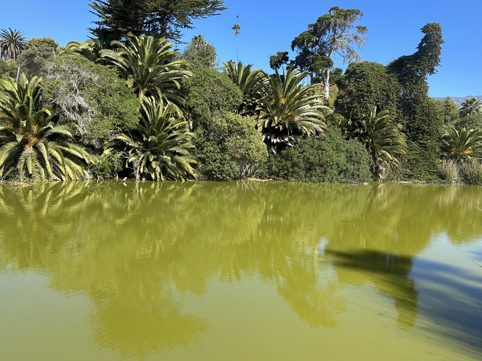
The Andrée Clark Bird Refuge sports a bright green color due to algae. This waterbody provides complex challenges for the Creeks Division to monitor and alleviate. (Credit: Caroline Shepherd)
Restoration in the Four Creeks
Santa Barbara’s Creeks Division has completed 10 restoration projects at various creeks, open spaces, and wetlands around the city, some stretching all the way back to 2003.
The reasons for restoration at these sites are varied. Some were done to benefit wildlife, like restoring a bird refuge or creating fish passages for the native but endangered Southern California steelhead trout.
However, Shepherd says that restoration often revolves around rewilding a creek that’s been straightened, lined with concrete, or even routed underground. In the past year, the division restored an 1,800-foot stretch of Mission Creek in the city’s Oak Park, right near the heart of Santa Barbara’s downtown.
Mission Creek was lined with concrete walls as it flowed through Oak Park, an odd sight in one of the city’s green spaces. The restoration was led by Creeks Division Project Planner Tim Burgess, who says, “These structures aimed to stop erosion but had the opposite long-term effect.”
The narrow and impervious channel increased the creek’s velocity, leading to erosive downcutting. The Creeks Division wanted to restore the creek to its “natural configuration,” which involved removing these walls, rebuilding a natural river bank, creating a flood plain, and planting thousands of native plants and trees to bring back its historic ecosystem.
“We wanted to give the creek room to breathe,” Shepherd says.
The division sampled the creek’s water quality both pre- and post-restoration. With this data, the city can better understand what is, or isn’t working, in these projects. Their most recent project was restoring a stretch of Arroyo Burro Creek nestled in the suburbs west of the city, where the creek was widened, and city-owned land replanted with native vegetation.
Shepherd says the Creeks Division will continue pursuing these restoration projects, relying on water quality data to make decisions.
However, Shepherd knows that the Creeks Division’s work can’t be done in silence, and they also emphasize educating the public on their many projects.
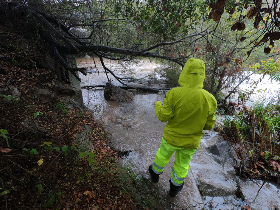
Shepherd is seen sampling from Arroyo Burro Creek’s bank at Cliff Drive during a rain event, as the creek is flooded in the area she normally takes samples from. (Credit: Laurie Van De Werfhorst)
Connecting the Streams to the Ocean
“Most people like the beach,” Shepherd says. “We need to connect that to the streams.”
That’s what guides the Creeks Division’s public outreach: connecting Santa Barbara’s most iconic destinations to the city’s sometimes unassuming creeks. Shepherd says that when people mostly see creeks by driving over bridges, they may fail to see their importance. That’s why restoring them to their natural, and more aesthetically pleasing, states can boost their visibility.
But Shepherd also knows it’s inherently part of her job to educate the public. She says local residents often approach her when she’s taking measurements in the field, wondering why she’s knee deep in a creek that nobody ever swims in.
These are the opportunities she grabs to share what she and other city scientists already know: creek health is important for beach health, and that requires continuous monitoring and data collection.
“Everyone wants clean beaches, and our creeks impact those beaches,” she says to anyone who asks.
Day in and day out, Shepherd says the Creeks Division continues putting in the work to protect the streams. Even though they can’t control the whole watershed from source to sea, they can impact creek health within the city.
This means keeping a watchful eye on creek health around the clock and improving these waterways wherever possible. Thanks to proactive monitoring and restoration, the Creeks Division hopes to continue protecting Santa Barbara’s unsung natural hero.
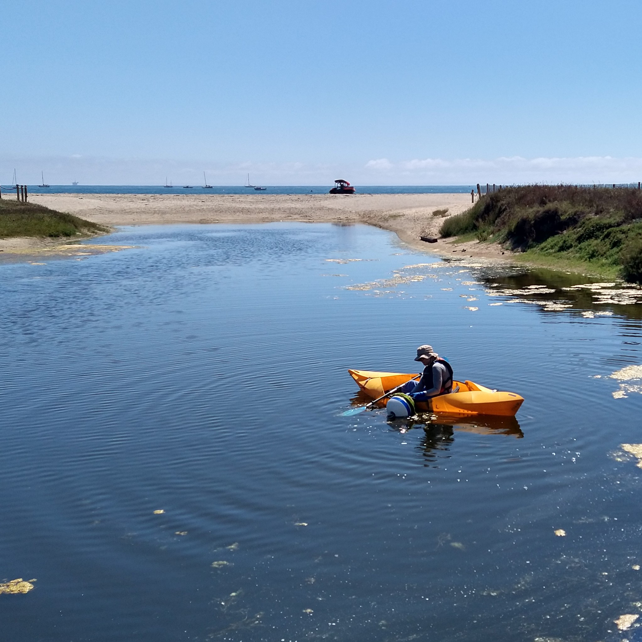
Shepherd checks a water quality monitoring device at the Lagoon of the Andrée Clark Bird Refuge at East Beach, which once connected to Sycamore Creek. (Credit: Laurie Van De Werfhorst)


0 comments