On Lake Champlain, states join up for long-term water quality monitoring
In Colonial times, Lake Champlain hosted significant naval engagements of the Revolutionary War and the War of 1812. Today, battles are waged over phosphorous concentrations, and the progress is marked by the multi-state Long-term Water Quality and Biological Monitoring Project.
Lake Champlain is large lake with a watershed that covers an area around 16 times greater than the lake itself, making it vulnerable to a wide variety of human impacts. It’s a long, skinny waterway that borders the states of New York, Vermont, and the Canadian province of Quebec. New York and Vermont have jointly managed the lake since the 1990s, a partnership that spawned a long-term data collection effort to track select chemical, physical and biological aspects of the system.
“It was recognized a long time ago that we’ve got to cooperate among ourselves to manage a lake across these jurisdictions,” said Eric Smeltzer, an environmental scientist with the Vermont Department of Environmental Conservation. “I think the fact that the long-term monitoring program is a joint effort by the two states is an outcome of that broader agreement to cooperate. We pool efforts in the long-term program to get the whole job done.”
From roughly May to October, crews from both states head out by boat to 15 sampling stations on the lake and more than 20 stations at the mouths of major tributaries. They lower bottle samplers to collect water for laboratory analysis for nutrients and a host of other chemical constituents. Phytoplankton and zooplankton samples are collected with nets.
Smeltzer said manually collecting samples–rather than a running a network of high-tech sensors–has worked for the program because lab tests are the best bet for determining the most important parameters for the lake like total phosphorous and total nitrogen.
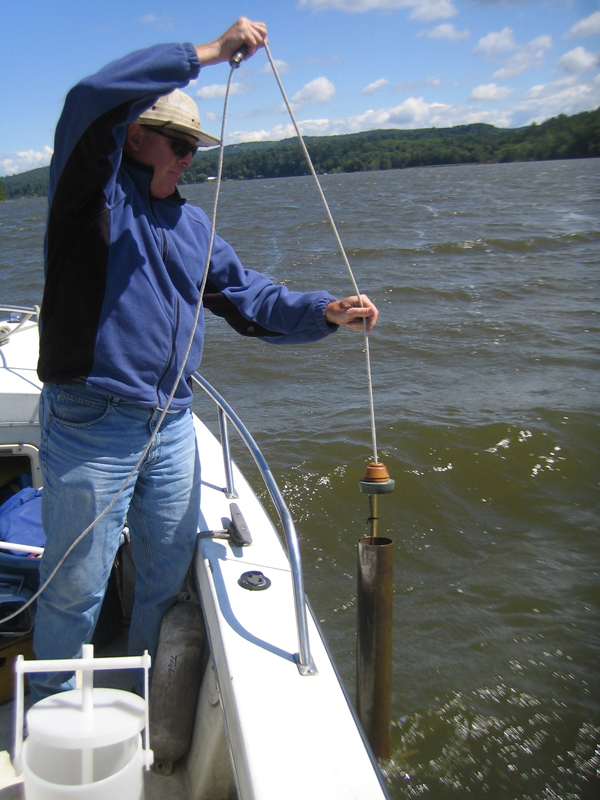
Samples are collected for most chemical tests using Kemmerer or Van Dorn water bottle devices (Credit: Vermont Department of Environmental Conservation)
The program does integrate some new technology into its methods, using a Hach Hydroloab multiparameter sonde for close interval vertical profile sampling of temperature, dissolved oxygen, pH, conductivity and chlorophyll a.
“That gives us the vertical picture in high resolution of some of those constituents that we don’t get by just lowering a water bottle sampler on a rope for 100 meters every 10 meters,” Smeltzer said. “That’s kind of laborious.”
Sticking with the basic methods the program was built on also keeps data uniform over a long time series.
“Once you’ve got 20 or 25 years of record you’re kind of reluctant to change anything because consistency is a really important factor in the long-term program,” he said.
Data from the program, along with historical data from other monitoring efforts, has helped reveal significant changes in the lake over time. For example, the August mean surface temperatures have increased by 1.6 to 3.8 degrees Celsius across many regions of the lake from 1964 to 2009.
“It looks like there has been a warming going on during the summer that we could document, he said. “That’s not that unusual, unfortunately. It’s consistent with trends in the Great Lakes and other lakes around the world.”
")
The crews take vertical profiles of some parameters with water quality sondes (Credit: Vermont Department of Environmental Conservation)
Water clarity, measured by Secchi disk depth, increased in the lake’s main stem over the same time period. An invasion of filter-feeding zebra mussels could be responsible for greater transparency in some parts of the lake. That hypothesis is supported by data from the program’s unique zebra mussel monitoring program, which the states initiated when the invaders were discovered in the lake in 1993.
Rather than track the density of adult zebra mussels on the bottom of the lake, monitoring crews collect the mussels’ planktonic larvae in tow nets.
“We’ve got one of the few consistent, long-term databases that tracks the spread of zebra mussels throughout a lake concurrently with all the water quality and other biological measures that we get through the monitoring program,” he said.
Though the mussels are likely the biggest influence on clarity in some parts of the lake, it’s also possible that the states’ efforts to cut phosphorous levels have had some effect. Those efforts have brought mixed results, but at least over some periods of time in some areas phosphorous inputs have gone down, Smeltzer said. And that may have some influence on clarity.
Phosphorous data from 1979 through 2009 in some of the main lake areas shows some declining trends, which is encouraging, Smeltzer said. But when looking isolating data from 1990 on, the trend is statistically upward almost everywhere.
“The monitoring is just helping us document that,” Smeltzer said. “Even though we’re disappointed not to be showing more success, at least we’re getting a better understanding of what we’re up against.”
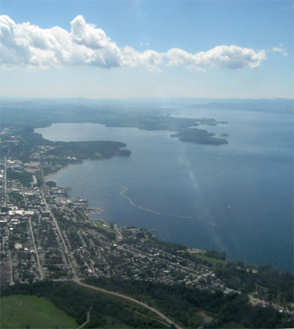
Top image: Lake Champlain (Credit: Nicki Dugan, via Flickr)


0 comments