Measuring Kootenai River Sediment To Help Endangered Sturgeon
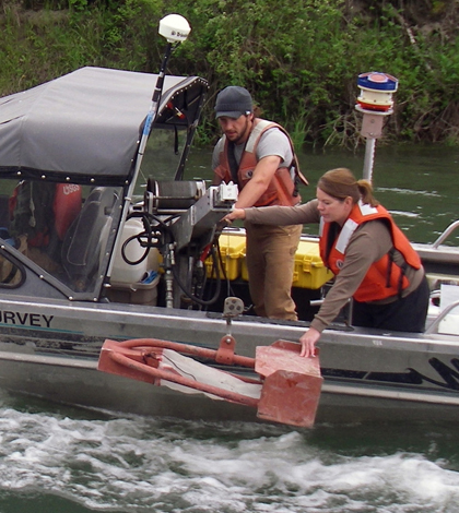
Hydrologic technicians retrieve a bedload sample from the Kootenai River near Bonners Ferry, Idaho. The U.S. Geological Survey compared the results of bedload and suspended sediment sampling with data collected from acoustic devices submerged in the river. (Credit: U.S. Geological Survey)
River sediments typically promote natural stream changes that provide food and habitat for fish. But for the endangered Kootenai River white sturgeon, too much sediment can be a bad thing.
It’s not so much an issue for the adults, but the fish’s eggs are easily smothered if there is too much sediment around. So keeping tabs on the sediments is therefore important for the long-term viability of the fish’s populations, which need to be protected if goals for restoring the river are to be met.
The Kootenai Tribe of Idaho is the primary organization working to improve conditions on the Kootenai River. In a recent work, they partnered with the U.S. Geological Survey to deploy acoustic Doppler velocity meters at three sites along the river near Bonners Ferry.
The submerged devices emit sound pulses into the river at specific frequencies, similar to sonar. The sound pulses reflect off sediment suspended in the water and then scientists can use the strength of the return signal, called backscatter, to calculate the amount of sediment particles flowing through the river.
The use of acoustic technology is improving the monitoring of sediments nationwide, researchers say. At monitoring sites along the Kootenai River, having the devices makes it possible to track high sediment transport through some of the most critical habitat reaches.
Acoustic meters were deployed near Crossport, a site below Moyie Springs and a Kootenai tribal hatchery. These gathered measurements from 2011 through 2014 on suspended sediment concentrations.

An acoustic Doppler velocity meter mounted on a track for instream deployment. The U.S. Geological Survey deployed devices similar to this at three monitoring sites on northern Idaho’s Kootenai River to estimate sediment concentrations in the spawning habitat of endangered Kootenai River white sturgeon. (Credit: U.S. Geological Survey)
USGS scientists found that total suspended sediment concentrations were driven primarily by tributaries flowing into the Kootenai River between Libby Dam and the areas under study. And they were highest during rain-on-snow events.
On average, the relative percentage of suspended sediment concentrations composed of fine materials was 73, 71, and 70 percent at the Moyie, Crossport, and tribal hatchery sites, respectively. Researchers found that suspended sand transport often increased with high streamflows, typically but not always associated with releases from Libby Dam.
Scientists also found the measurements useful following a large December rain storm, after which they were able to track the sediment concentrations as they surged and then subsided.
Members of the Kootenai Tribe say that the partnership with the USGS has provided a lot of valuable insights over the years. The knowledge has helped them to design and implement restoration projects, as well as evaluate their impacts.
Full results of the study are published under open-access license in the USGS Publications Warehouse.
Top image: Hydrologic technicians retrieve a bedload sample from the Kootenai River near Bonners Ferry, Idaho. The U.S. Geological Survey compared the results of bedload and suspended sediment sampling with data collected from acoustic devices submerged in the river. (Credit: U.S. Geological Survey)


0 comments