
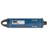
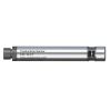
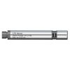
HOBO Dissolved Oxygen Sensor
Features
- User-replaceable DO cap lasts 2 years or more
- High accuracy measurements, even without calibration
- Get salinity-adjusted DO directly when used with conductivity sensor (W-CT or W-CTD)
- Free ground shipping
- Expedited repair and warranty service
- Lifetime technical support
- More
The dissolved oxygen sensor is an interchangeable sensor that works with HOBO MX800 Series Water Loggers to measure dissolved oxygen and temperature. The DO sensor can be attached directly to the fully submersible MX801 model, or attached via cable to the direct read MX802 model, which doesn’t require having to pull the sensor out of the water to download data.
When this sensor is connected to a HOBO MX800 logger that also has a conductivity or CTD sensor attached, the logger can record salinity-adjusted DO directly. With this sensor attached to the HOBO MX802 direct read model, the logger can calculate DO percent saturation directly. When used with fully submersible HOBO MX801 model, a barometric logger data file (from either an MX802 or MX2001 logger) is needed to calculate DO percent saturation, for post-processing in the HOBOconnect app. In waters with changing salinity, the logger must also have a salinity sensor attached or you will need an MX800 salinity data file to get DO percent saturation.
- User-replaceable DO cap lasts 2 years or more
- High accuracy measurements, even without calibration
- Get salinity-adjusted DO directly when used with conductivity sensor (W-CT or W-CTD), no need for post-processing
- Direct DO percent saturation data, no need for post-processing (when used with MX802)
- Easy calibration with included calibration boot – saves time
- 1” diameter for use in narrow wells (with cable to MX802 above the well)
- PVC housing holds up in saltwater
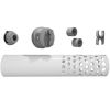
- (1) Dissolved oxygen sensor
- (1) Dissolved oxygen sensor cap
- (1) Calibration boot and sponge
Select Options


In The News

From Paddles to Phytoplankton: Studying Vermont’s Wildest Lakes
For six months of the year, Rachel Cray, a third-year PhD student at the Vermont Limnology Laboratory at the University of Vermont, lives between a microscope and her laptop, running data. For the other six months, she is hiking and canoeing four of Vermont’s lakes, collecting bi-weekly water samples. Cray studies algal phenology across four lakes in Vermont, US, that have low anthropogenic stress—or in other words, are very remote. Funded by the National Science Foundation Career Award to Dr. Mindy Morales, the lakes Cray researches part of the Vermont Sentinel Lakes Program, which studies 13 lakes in the area and, in turn, feeds into the Regional Monitoring Network, which operates in the Northeast and Midwest US.
Read More
Reimagining Water Filtration: How Monitoring and Science Enhance FloWater Filtration Systems
Over 50% of Americans think their tap water is unsafe , according to the Environmental Working Group (EWG). Other recent surveys have found that number to be as high as 70% of persons surveyed. Whether due to increased public awareness of water quality issues or confusion about how municipal water sources are regulated, there is a clear distrust of tap water in the United States. According to industry expert Rich Razgaitis, CEO and co-founder of the water purification company FloWater, this issue creates a damaging cycle. Razgaitis explained that the health and environmental problems associated with contaminated water aren’t the only issues. As people become increasingly aware that some tap water is unsafe, they resort to bottled water.
Read More
Monitoring New Hampshire’s Aquatic Ecosystems: Continuous Data Collection in the Lamprey River Watershed
New Hampshire’s aquatic ecosystems provide a range of ecosystem services to the state and region. Resources and services like clean water, carbon storage, climate regulation, nutrient regulation, and opportunities for recreation all depend on New Hampshire’s aquatic ecosystems remaining healthy. Jody Potter, an analytical instrumentation scientist at the University of New Hampshire (UNH), is studying these aquatic ecosystems in hopes of developing an improved understanding of ecosystem services and their interactions with climate change, climate variability, and land use changes. [caption id="attachment_39799" align="alignnone" width="940"] Aquatic sensors in the Merrimack River in Bedford, NH, with I-293 in the background.
Read More