
HOBOnet Wireless Water Level Sensor Interface
Features
- 900 MHz wireless mesh self-healing technology
- 450 to 600 meter (1,500 to 2,000 feet) wireless range and up to five hops
- Up to 50 wireless sensors or 336 data channels per HOBO RX station
- Free ground shipping
- Expedited repair and warranty service
- Lifetime technical support
- More
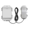
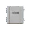
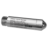
The HOBOnet water level sensor interface features a pre-configured, easily deployed wireless sensor that communicates accurate, reliable water level data directly to a HOBO RX3000 or HOBO MicroRX station, the core component of the HOBOnet remote monitoring system.
HOBOnet is a cost-effective, scalable, user-friendly wireless sensor network that lets you streamline data retrieval by effortlessly monitoring multiple wells with a single cellular device. Data is accessed from anywhere, at any time, through the customizable dashboard in HOBOlink, Onset's innovative cloud software platform – eliminating the need for frequent site visits that are both time-consuming and costly. HOBOlink also sends automatic, real-time text/email notifications to alert you of any sensor or system alarms, providing the insights you need to make informed decisions, react quickly to stay ahead of issues, and ensure compliance.
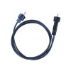
A complete system requires at least one HOBOnet Water Level Sensor, a direct read cable, and a HOBO RX3000 Remote Monitoring Station and HOBOnet Wireless Manager (or a HOBO MicroRX Station with an integrated HOBOnet Wireless Manager). HOBOnet Wireless Repeaters can be added to extend the range.
Select Options


In The News

From Paddles to Phytoplankton: Studying Vermont’s Wildest Lakes
For six months of the year, Rachel Cray, a third-year PhD student at the Vermont Limnology Laboratory at the University of Vermont, lives between a microscope and her laptop, running data. For the other six months, she is hiking and canoeing four of Vermont’s lakes, collecting bi-weekly water samples. Cray studies algal phenology across four lakes in Vermont, US, that have low anthropogenic stress—or in other words, are very remote. Funded by the National Science Foundation Career Award to Dr. Mindy Morales, the lakes Cray researches part of the Vermont Sentinel Lakes Program, which studies 13 lakes in the area and, in turn, feeds into the Regional Monitoring Network, which operates in the Northeast and Midwest US.
Read More
Reimagining Water Filtration: How Monitoring and Science Enhance FloWater Filtration Systems
Over 50% of Americans think their tap water is unsafe , according to the Environmental Working Group (EWG). Other recent surveys have found that number to be as high as 70% of persons surveyed. Whether due to increased public awareness of water quality issues or confusion about how municipal water sources are regulated, there is a clear distrust of tap water in the United States. According to industry expert Rich Razgaitis, CEO and co-founder of the water purification company FloWater, this issue creates a damaging cycle. Razgaitis explained that the health and environmental problems associated with contaminated water aren’t the only issues. As people become increasingly aware that some tap water is unsafe, they resort to bottled water.
Read More
Monitoring New Hampshire’s Aquatic Ecosystems: Continuous Data Collection in the Lamprey River Watershed
New Hampshire’s aquatic ecosystems provide a range of ecosystem services to the state and region. Resources and services like clean water, carbon storage, climate regulation, nutrient regulation, and opportunities for recreation all depend on New Hampshire’s aquatic ecosystems remaining healthy. Jody Potter, an analytical instrumentation scientist at the University of New Hampshire (UNH), is studying these aquatic ecosystems in hopes of developing an improved understanding of ecosystem services and their interactions with climate change, climate variability, and land use changes. [caption id="attachment_39799" align="alignnone" width="940"] Aquatic sensors in the Merrimack River in Bedford, NH, with I-293 in the background.
Read More