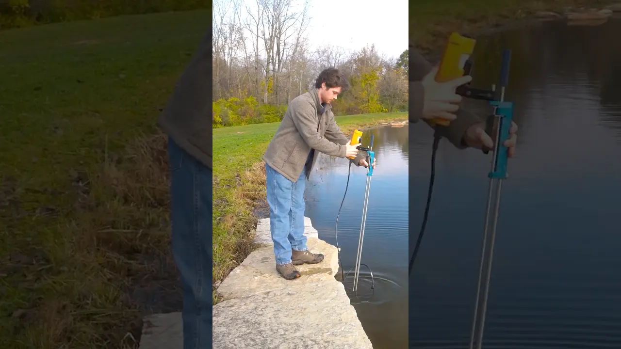
SonTek FlowTracker2 Handheld ADV
America’s Premier Xylem and YSI Dealer!
America’s Premier Xylem and YSI Dealer!
- Expedited repair and warranty service
- Lifetime technical support
- More
- Improved ADV acoustics: faster pinging, lower noise and better standard error
- Embedded GPS for geo-referencing with automatic or manual fixes
- Set up and save templates—no need to re-enter data every time you visit a site
Overview
The SonTek FlowTracker2 (FT2) handheld Acoustic Doppler Velocimeter (ADV) is a wading discharge measurement instrument that is handheld, portable and precise. 2-D data in the horizontal plane (2D/3D option available) allows the most comprehensive QC and understanding about flow conditions. User calibration is never required.
Benefits
- Embedded GPS for georeferencing with automatic or manual fixes
- Improved ADV acoustics: faster pinging, lower noise and better standard error
- Battery life icon on the screen at all times. Pre-load the spare cartridge and replace, even mid-measurement, with no data loss
- Detachable probe with extension cables to customize cable length up to 10m
- Probes and handhelds are interchangeable—flexibility within agency teams and when sending equipment for service
- Set up and save templates—no need to re-enter data every time you visit a site
- Bluetooth or direct USB interface with PC
- Audio prompts
Handheld Specifications
| Input Battery Voltage | 8 - 12 VDC |
| Power Supply | 8 X AA Batteries |
| Battery Life | 11 hours continuous use, typical settings1 |
| Power Consumption | 1 W (Average) |
| GPS: H. Position Accuracy | Up to 2.5 m (8.2 ft) nominal2 |
| GPS: Frequency | L1 (1.575 MHz) SBAS compensation (WAAS, EGNOS, MSAS, GAGAN) |
| LCD Resolution | 320 X 240 TFT Transmissive |
| Bluetooth | Class 2, Range = 10 m (33 ft) nominal |
| USB | Micro USB, IP-67 |
| Battery Power to Probe | 8 - 12 VDC |
| Data Transfer | RS-232 |
| Data Storage | 16 GB. Up to 10k discharge measurements Up to 10 million velocity samples |
| Operating Temperature | Alkaline Batteries: -20° to 45°C (-4°F to 113°F) NiMH: -20° to 50°C (-4°F to 122°F) |
| Storage Temperature | -30° to 70° C (-22° F to 158° F)3 |
| Waterproof Rating | IP-67 (1m submersible) |
| Handheld Dimensions | (L)10.4 cm (4.1 in) (W) 6.4 cm (2.5 in) (H) 23.7cm (9.3 in) |
| Weight in Air | 0.75 kg (1.65 lbs) |
| Weight in Water | -0.25 kg (-0.55 lbs) |
Probe Specifications
| Velocity Range | ±0.001 to 4.0 m/s (0.003 to 13 ft/s) |
| Velocity Resolution | 0.0001 m/s (0.0003 ft/s) |
| Velocity Accuracy | +/1% of measured velocity, +/- 0.25cm/s |
| Acoustic Frequency | 10.0 MHz |
| Sampling Volume Location | 10 cm (3.93 in) from the center transducer |
| Minimum Depth | 0.02 m (0.79 in) |
| Depth Measurement Range | 0 to 10m (0 to 32.81ft) |
| Depth Measurement Resolution | 0.001m (0.003ft) |
| Depth Sensor Accuracy | +/- 0.1% of FS (temperature compensated over full operating range) |
| +/- 0.05% Static (steady-state at 25°C) | |
| Additionally compensated for real-time water velocity, temperature, salinity, and altitude. |
|
| Temperature Sensor | Resolution: 0.01° C, Accuracy: 0.1° C |
| Tilt Sensor | Resolution: 0.001°, Accuracy: 1.0° |
| Communication Protocol | RS-232 |
| Operating/Storage Temperature | -20° C to 50° C (-4° F to 122° F) |
| Probe Head Dimensions | (L)13.3 cm (5.22 in) (W) 6.1 cm (2.39 in) (H) 2.3 cm (0.90 in) |
| Standard Cable Length | 1.5 m (4.92 ft) |
| Weight in Air | 0.90 kg (1.98 lbs) |
| Weight in Water | 0.30 kg (0.66 lbs) |
- (1) FlowTracker2 handheld display unit
- (1) USB interface cable
- (1) Spare battery cartridge
- (8) AA alkaline batteries
- (1) Shipping case
- Improved ADV acoustics: faster pinging, lower noise and better standard error
- Embedded GPS for geo-referencing with automatic or manual fixes
- Set up and save templates—no need to re-enter data every time you visit a site
Overview
The SonTek FlowTracker2 (FT2) handheld Acoustic Doppler Velocimeter (ADV) is a wading discharge measurement instrument that is handheld, portable and precise. 2-D data in the horizontal plane (2D/3D option available) allows the most comprehensive QC and understanding about flow conditions. User calibration is never required.
Benefits
- Embedded GPS for georeferencing with automatic or manual fixes
- Improved ADV acoustics: faster pinging, lower noise and better standard error
- Battery life icon on the screen at all times. Pre-load the spare cartridge and replace, even mid-measurement, with no data loss
- Detachable probe with extension cables to customize cable length up to 10m
- Probes and handhelds are interchangeable—flexibility within agency teams and when sending equipment for service
- Set up and save templates—no need to re-enter data every time you visit a site
- Bluetooth or direct USB interface with PC
- Audio prompts
Handheld Specifications
| Input Battery Voltage | 8 - 12 VDC |
| Power Supply | 8 X AA Batteries |
| Battery Life | 11 hours continuous use, typical settings1 |
| Power Consumption | 1 W (Average) |
| GPS: H. Position Accuracy | Up to 2.5 m (8.2 ft) nominal2 |
| GPS: Frequency | L1 (1.575 MHz) SBAS compensation (WAAS, EGNOS, MSAS, GAGAN) |
| LCD Resolution | 320 X 240 TFT Transmissive |
| Bluetooth | Class 2, Range = 10 m (33 ft) nominal |
| USB | Micro USB, IP-67 |
| Battery Power to Probe | 8 - 12 VDC |
| Data Transfer | RS-232 |
| Data Storage | 16 GB. Up to 10k discharge measurements Up to 10 million velocity samples |
| Operating Temperature | Alkaline Batteries: -20° to 45°C (-4°F to 113°F) NiMH: -20° to 50°C (-4°F to 122°F) |
| Storage Temperature | -30° to 70° C (-22° F to 158° F)3 |
| Waterproof Rating | IP-67 (1m submersible) |
| Handheld Dimensions | (L)10.4 cm (4.1 in) (W) 6.4 cm (2.5 in) (H) 23.7cm (9.3 in) |
| Weight in Air | 0.75 kg (1.65 lbs) |
| Weight in Water | -0.25 kg (-0.55 lbs) |
Probe Specifications
| Velocity Range | ±0.001 to 4.0 m/s (0.003 to 13 ft/s) |
| Velocity Resolution | 0.0001 m/s (0.0003 ft/s) |
| Velocity Accuracy | +/1% of measured velocity, +/- 0.25cm/s |
| Acoustic Frequency | 10.0 MHz |
| Sampling Volume Location | 10 cm (3.93 in) from the center transducer |
| Minimum Depth | 0.02 m (0.79 in) |
| Depth Measurement Range | 0 to 10m (0 to 32.81ft) |
| Depth Measurement Resolution | 0.001m (0.003ft) |
| Depth Sensor Accuracy | +/- 0.1% of FS (temperature compensated over full operating range) |
| +/- 0.05% Static (steady-state at 25°C) | |
| Additionally compensated for real-time water velocity, temperature, salinity, and altitude. |
|
| Temperature Sensor | Resolution: 0.01° C, Accuracy: 0.1° C |
| Tilt Sensor | Resolution: 0.001°, Accuracy: 1.0° |
| Communication Protocol | RS-232 |
| Operating/Storage Temperature | -20° C to 50° C (-4° F to 122° F) |
| Probe Head Dimensions | (L)13.3 cm (5.22 in) (W) 6.1 cm (2.39 in) (H) 2.3 cm (0.90 in) |
| Standard Cable Length | 1.5 m (4.92 ft) |
| Weight in Air | 0.90 kg (1.98 lbs) |
| Weight in Water | 0.30 kg (0.66 lbs) |
- (1) FlowTracker2 handheld display unit
- (1) USB interface cable
- (1) Spare battery cartridge
- (8) AA alkaline batteries
- (1) Shipping case
Select Options


PRODUCT VIDEOS


Customer Stories


