Monitoring Volcanic Activity in Hawaii: Safeguarding Public Safety with the Hawaiian Volcano Observatory
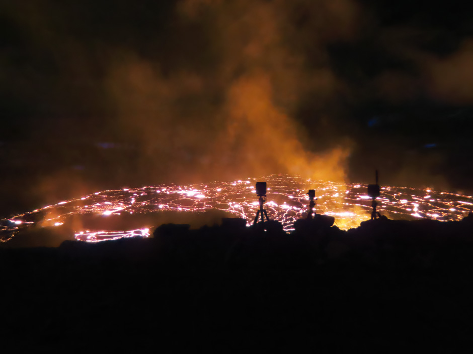 Webcam sentinels stand watch over the new eruption within Halema‘uma‘u Crater, at the summit of Kīlauea, in the early morning hours of January 6, 2023. (Credit: J.M. Chang. / USGS)
The eight main Hawaiian Islands are made up of 15 volcanoes, six of which are active as of 2023. Many locals live on or near an active volcano, making the monitoring and understanding of volcanic activity a core issue of public safety on the islands. Organizations like the Hawaiian Volcano Observatory (HVO) have spent decades monitoring the islands’ volcanoes to protect the public, develop a deeper understanding of the islands’ volcanos and forecast eruptions whenever possible.
Even those who live away from edifices like Mauna Loa often have connections to the people living near the volcano. It’s the pursuit of knowledge and understanding the complexities of volcanic activity that drive the work of scientists like Kevan Kamibayashi, a supervisory electronics technician with the Hawaiian Volcano Observatory.
When Kamibayashi was in intermediate school, a program offered to Native Hawaiian children, Nā Pua No’eau, introduced him to the world of natural science. More specifically, Kamibayashi was enrolled in a program called Rock and Rolls, which was headed by two instructors, Jim Anderson, a professor at the University of Hawaiʻi at Hilo and Jim Kauahikaua, who was a geophysicist at HVO.
Students would be taken out into the field and taught various survey techniques for lava flow monitoring. “I kind of got hooked to this whole world of geology ever since then,” explains Kamibayashi. His experience led him to pursue a geology degree at the University of Hawaiʻi at Hilo and his later employment at HVO in 1998.
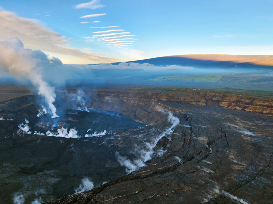
During a Kīlauea summit morning monitoring overflight on February 2, 2023, HVO scientists documented activity in the ongoing Halema‘uma‘u eruption, shown in this photo looking to the SW at 7:30 a.m. HST. Mauna Loa is visible in the background. (Credit: K. Lynn / USGS)
The History of Volcano Monitoring in Hawaii
Before he became a supervisory electronics technician in 2010, Kamibayashi started working in the geodetic sector of the observatory. At the time, Kamibayashi worked with instruments like GPS, tilt meters, gravimeters, electronic distance measurements, level tilt and anything focused on geodetics and ground deformation. However, both sampling techniques and HVO have changed drastically over the decades.
At the time, the program was comprised of segregated networks that focused on various scientific disciplines. Within the observatory, there would be a group that monitored seismology, ground deformation, gas and geochemistry and a geology group—all of which were disconnected from one another.
Part of the reason behind this isolation in disciplines was the result of the limitations in technology at the time. “The old analog seismic systems didn’t allow for adding additional data streams into the same telemetry network. And so when you expanded these networks to also include GPS, you’d essentially have to build out an entirely separate telemetry system for that type of instrument,” explained Kamibayashi.
The organization of HVO changed drastically in 2009 as a result of the American Reinvestment and Recovery Act which allowed HVO to overhaul the monitoring network completely. HVO was able to digitize all of its monitoring capabilities which paved the way for today’s monitoring network. Kamibayashi elaborates that you can essentially integrate any instrument with a digital communication capability into the new system.
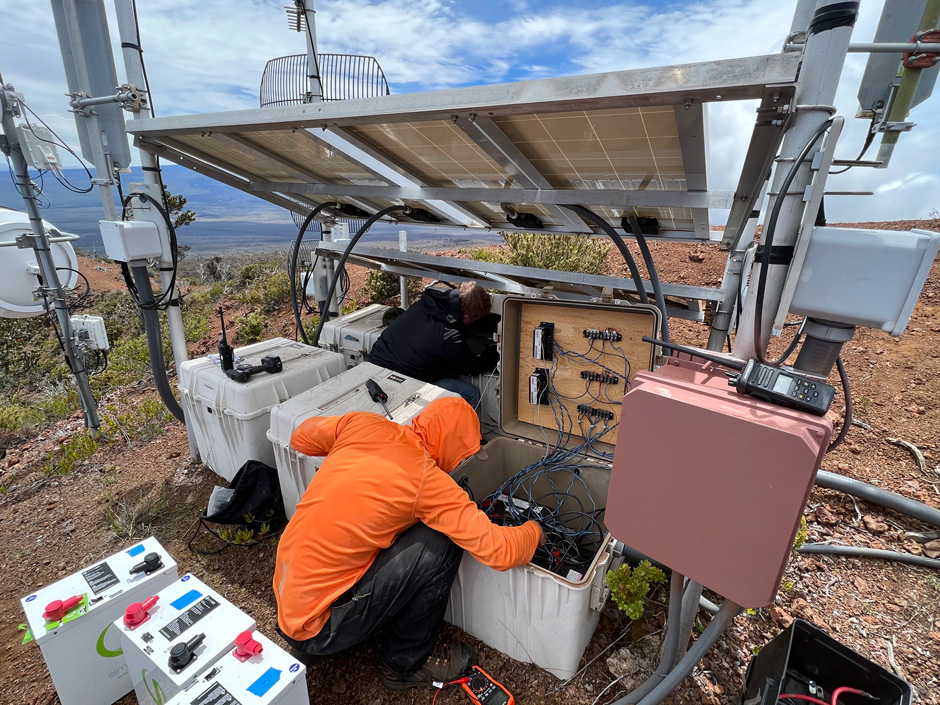
A Hawaiian Volcano Observatory technician replaces batteries on the Hualālai repeater station. The station, which relays monitoring signals from nearby stations back the observatory, is powered by batteries that store energy generated by solar panels. (Credit: M. Warren / USGS)
Maintaining the Hawaiian Volcano Observatory Network
The transition in 2009 allowed the field engineers to be consolidated into one team managed by Kamibayashi. Nowadays, monitoring looks different thanks to the integration of telemetric systems and the use of solar power to maintain the system and remotely receive data. Fieldwork is generally comprised of proactive or reactive maintenance.
Proactive maintenance keeps the network healthy and follows a general routine wherein about 20% of the monitoring network is serviced each year. Alternatively, reactive maintenance involves responding to random outages like premature failures.
A large percentage of the monitoring network is only accessible by helicopter, so researchers spend a lot of time in the air and off-roading to reach sites. Thanks to the integration of telemetry devices, the frequency of these trips has been limited. Kamibayashi explains, “I used to joke around about this and say, ‘Well, you know, my job is to check emails and then respond to them.’ And that’s because we’ve established alarms and alerts for when there’s issues. So when our automated systems see these, then we tend to them.”
When fieldwork is necessary, the team prepares by researching and building out new instrumentation packages and monitoring systems in the shop and then preparing for deployment. The variety of the work creates unique challenges but also keeps team members and the advancement of the system from becoming stagnant.
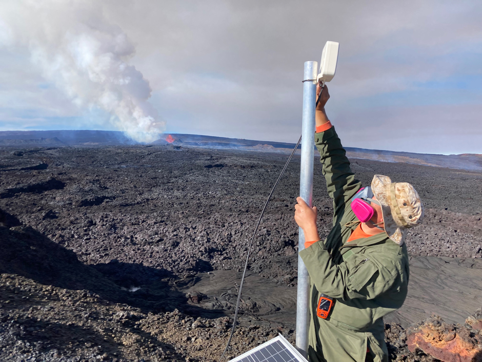
An HVO scientist installs a web camera to monitor the Northeast Rift Zone eruption of Mauna Loa. (Credit: M. Patrick / USGS)
How the Hawaiian Volcano Observatory Monitors Volcanic Activity
HVO’s network is spread out across Mauna Loa, Kīlauea, Hualālai, Kohala and Mauna Kea volcanoes. The 240-site network includes a diverse array of instrumentation and is solar-powered. Some of the devices used in the field include common environmental monitoring equipment like GNSS GPS receivers, tilt meters, gas monitoring instruments and cameras. Alternatively, some equipment is more specialized, like short-period seismometers, accelerometers, infrasound sensors, gravimeters, upward-looking UV spectrometers and a sulfur dioxide (SO2) camera.
While most of these sites are standalone instruments, some newer sites have a colocation. Kamibayashi provides an example of an array of 10 sites with upward-looking UV spectrometers that can work together as one system downwind of the volcanic plume and give SO2 concentrations. For more remote and inaccessible sampling needs, HVO uses drones equipped with LiDARs or other equipment to reach the data they need.
A long-term monitoring system like the HVO network is vital for monitoring and understanding volcanoes. By gathering data over a long period, researchers and scientists can identify shifts and trends that deviate from expected ranges, which may indicate an eruption.
“As an example, Mauna Loa erupted last year at the end of November. Three months leading up to that, we started seeing strange signals and seismic energy, we also started seeing inflation of the volcanic edifice through our tilt meters and GPS stations,” states Kamibayashi. “I’m always impressed by what they’re able to do and how they’re able to visualize what’s going on volcanically through looking at essentially squiggly lines and numbers,” he continues.
Having access to and being able to interpret the data gathered by the network is what allowed seismologists to confidently say that they could go from the current levels of activity to lava breaching the surface in less than a few hours. HVO then began raising awareness in the communities on the Island of Hawaiʻi by conducting public meetings and interviews.
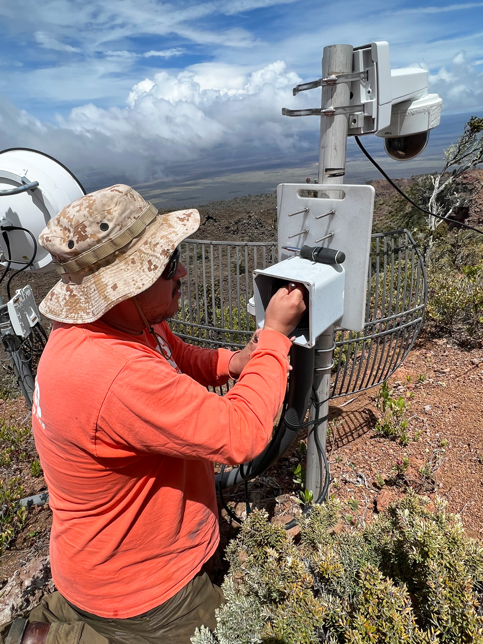
During station maintenance at the Hualālai repeater, Hawaiian Volcano Observatory technicians installed a new webcam, the HLcam. This camera is located on Hualālai and provides view of Mauna Loa’s northwest flank. (Credit: M. Warren. / USGS)
The Significance of Volcano Monitoring
While HVO is now considered an authority on eruptions and other volcanic activity, the public was not always invested in the group’s work. For many years, volcanic activity was confined within the National Park. It wasn’t until 2014, when lava flows started heading towards Pāhoa town, that the public got involved. Kamibayashi explains, “The county set up all these public meetings, and HVO was a participant in these meetings where we would work with the county to present information about what was going on at the volcano.”
The Pāhoa community meetings were a major milestone in building relationships with the public, according to Kamibayashi. The flows had the potential of cutting off access to a big part of the island where people live, so the public was invested in learning about the volcanos and what HVO was observing. Kamibayashi says that these meetings were significant for the organization as well because the public was learning, and their interest paved the way for the outreach the observatory does today.
Conclusion
The strength of that relationship has been demonstrated in every major eruption since Pāhoa. The combined work of researchers, scientists and the public information department helped solidify the positive relationship reflected today. Those relationships are meaningful because people live on these volcanoes; having those connections makes minimizing and avoiding harm easier.
The power of outreach and reliability is evident from the success of Mauna Loa’s disaster mitigation efforts. Thanks to the continued communication of HVO, no one was harmed in the 2022 eruption. While eruptions are never good, Kamibayashi explains, “It is rewarding to know that we were able to detect it, we were able to warn the public about it and as a result, no one was hurt or injured.” He goes on to state, “I think it’s one of the things that drives us–it’s probably the reason people work too much!”
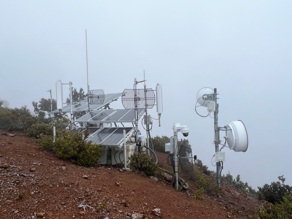
During the week of April 10, Hawaiian Volcano Observatory technicians upgraded the Hualālai repeater site, which is an important telemetry hub for volcano monitoring data. The site is located on the southeast side of Hualālai, at an elevation of 2,160 meters (7,090 feet) above sea level. This photo, taken after the upgrades were completed, shows the site enshrouded in fog. Upgrades included replacing the batteries, installing a new electronics system and box, and installing a new webcam looking at Mauna Loa. The station upgrades and new webcam were funded by the USGS Additional Supplemental Appropriations for Disaster Relief Act of 2019. (Credit: M. Warren / USGS)


0 comments