Real-Time Bridge Scour Tracked In Western Colorado
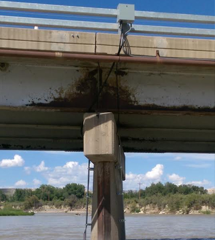
Airmar EchoRange SS510 Smart Sonar Depth Sensors (underwater) connect to a remote telemetry unit and data logger mounted on a bridge in western Colorado. (Credit: U.S. Geological Survey)
Editor’s Note: Any use of trade, firm, or product names is for descriptive purposes only and does not imply endorsement by the U.S. Government.
When we drive over bridges, we probably don’t think too much about the water body that we’re crossing. After all, the only thing we see are the cars in front of us and the asphalt beneath our tires. But there is something incredibly important occurring just under the water’s surface: bridge scour.
All over the United States, government agencies keep an eye on bridge scour because of the damaging impacts it can have if left to fester. Too much erosion around piers supporting bridges can threaten bridge collapse and endanger driver safety.
One of the agencies that keeps tabs on bridge scour is the U.S. Geological Survey (USGS). In a recent project in partnership with the Colorado Department of Transportation, researchers with the USGS set up stations to monitor bridge scour in real time.
The work focused on two bridges in western Colorado. Relying on Airmar EchoRange SS510 Smart Sonar Depth Sensors mounted on bridge piers, USGS scientists didn’t find any surprises in the effort.
“We are using the depth sensors to measure the streambed elevations. … To provide real-time streambed elevations during high-flow periods,” said Mark Henneberg, hydrologist with the agency’s Colorado Water Science Center.

Airmar EchoRange SS510 Smart Sonar Depth Sensors (underwater) connect to a remote telemetry unit and data logger mounted on a bridge in western Colorado. (Credit: U.S. Geological Survey)
To gather data in real time, USGS scientists rigged up data loggers on the bridges that are equipped with telemetry, such as cellular or satellite, to ping measurements to them at project-defined intervals.
Complementing those data are measurements on water level that are gathered as part of another USGS effort.
“River stage is also being measured by existing gaging station infrastructure,” said Henneberg.
That’s important because high water levels, or flooding, can coincide with increased bridge scour. This is especially true because water tends to flow faster around piers and abutments, increasing the scour they experience on a more local level.
Top image: Airmar EchoRange SS510 Smart Sonar Depth Sensors (underwater) connect to a remote telemetry unit and data logger mounted on a bridge in western Colorado. (Credit: U.S. Geological Survey)


0 comments