The Hidden Work Behind Coastal Knowledge: A Buoy off Kusu Island, Singapore
Singapore is a small island country and city-state in Southeast Asia. At around 730km2–and slowly growing thanks to land reclamation efforts–it’s one of the most densely populated nations in the world.
Although limited by physical space and resources, Singapore’s powerhouse economy is built on manufacturing and wholesale trade, which rely in part on its strategic location. Situated at the southern tip of Peninsular Malaysia, connecting the Straits of Malacca and the South China Sea, Singapore has been the world’s busiest port outside of China by tonnage since 1986.
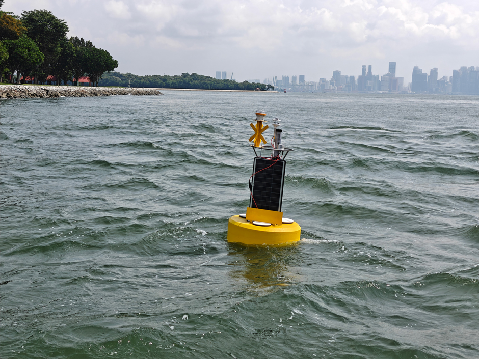
The buoy is located off Kusu Island and measures waves, current, and weather. The Elcee team conducts regular maintenance to collect data and ensure the buoy continues to work effectively and within regulations. (Credit: Abhishek Datla)
An Interlinked Climate and Ocean System
Physical oceanographic characteristics, including waves and currents, significantly impact port activities, coastal morphodynamics, and ecosystem functioning–making it imperative to understand their physical characteristics and variability.
With year-round high temperatures and humidity, Singapore’s tropical climate is defined by two monsoon seasons–the Northeast Monsoon, from early December to early March, and the Southwest Monsoon, from June to September.
Changing wind stress during the monsoons correspondingly influences currents and wave energy, although this remains poorly constrained.
Abhishek Datla is Sales Manager at Elcee Instrumentation and Services, a Malaysian-based company that distributes oceanographic, environmental, and meteorological systems–including NexSens equipment–across Southeast Asia and beyond.
In summer 2025, he deployed a NexSens CB-1250 off Kusu Island, Singapore, equipped to measure waves, current, and weather, to provide more data on these vital coastal characteristics.
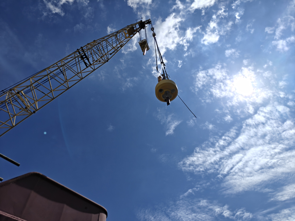
The CB-1250 is the biggest buoy in the NexSens offer. It was lifted via crane onto the barge before being taken to the deployment location. (Credit: Abhishek Datla)
Building the Right Buoy System
Datla was first approached by a client in 2022, interested in measuring “currents, waves and wind, to explore seasonal trends and wave energy changes during the monsoon.”
With an academic background in Oceanography and years of hands-on experience working in the field, Datla proposed a Nortek Aquadopp single-point current meter, SeaView Systems SVS-603HR Wave Sensor and Gill MaxiMet Marine Compact Weather Station, able to provide real-time data via a cellular-enabled NexSens X3 data logger, and deployed on a NexSens CB-1250.
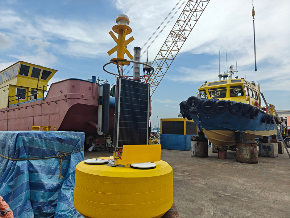
Datla recommended the CB-1250 for its larger power capacity–there are three 71-watt solar panels on the tower, and it can accommodate up to four 28 A-Hr batteries in the battery well.
“Beyond meeting the power requirements, the CB-1250 was chosen for its larger sensor payload capacity, improved visibility in high-traffic waters, and the overall platform robustness which is critical for withstanding the strong currents at the deployment site,” he notes. With 1044 lb net buoyancy, the CB-1250 is the largest in the NexSens offer.
Fast forward to 2024, and the project was opened up for companies to submit quotes. With lots of marine operations, equipment and expertise required, Datla was confident that Elcee would be able to provide the best solution. In March 2025, Elcee was awarded the contract, and preparations began for deployment.
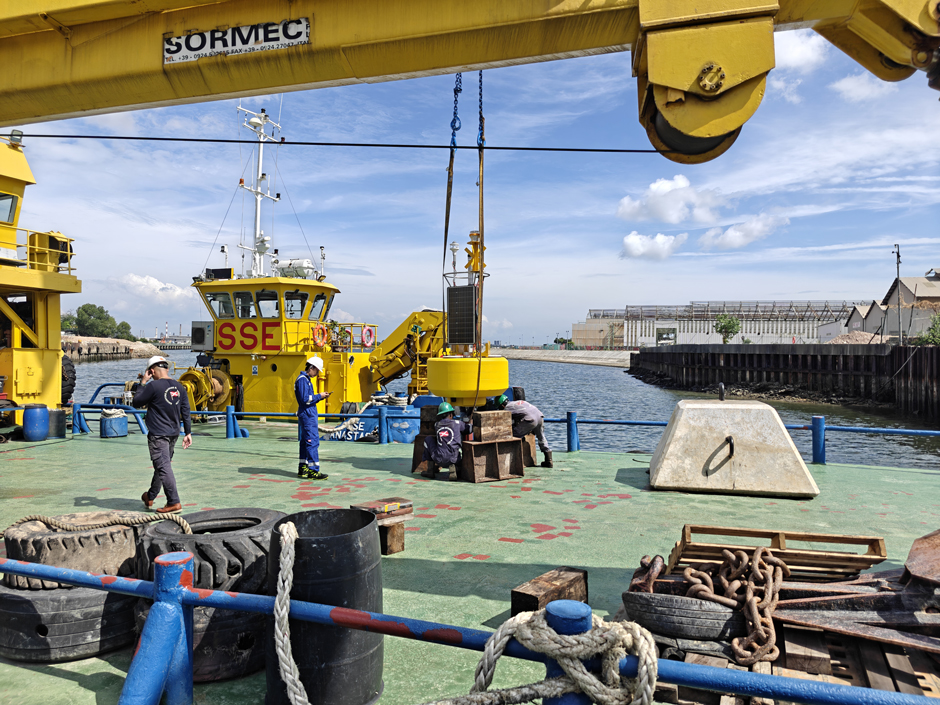
After months of meticulous preparation, the Elcee team makes final preparations for buoy deployment. After months of meticulous preparation, the Elcee team makes final preparations for buoy deployment.
Deploying the New Data Buoy
With the deployment location identified off Kusu Island, some 5.6km south of Singapore’s main island, Datla worked with Alex Ng from Orcades Marine Asia, an experienced marine engineer consultant in Singapore to plan the deployment, which presented some challenges for the team.
“At any one time, there are about 1,000 vessels in the port, arriving around the clock,” Ng explains, “Hence the buoy deployed has to undergo reviews by independent parties and inspection by the authorities before being deemed safe to deploy.”
Furthermore, to comply with navigation safety requirements, the buoy’s movement has to be confined to a prescribed 35m excursion radius. To add to this, the relatively shallow deployment location regularly sees tidal currents exceeding 3 knots.
“Our team chose to adopt a 28m chain and rope catenary mooring in the Lazy-S configuration for a water depth of 11m and tidal range of 3.5m. The anchor is a 5.5 tonne concrete sinker to resist the tidal currents,” Ng elucidates.
The buoy also allowed for the necessary aids, such as radar reflectors, St. Andrews Cross, and a solar marine lantern to be installed on it to ensure navigational visibility.
In June 2025, the buoy was ready for deployment. “It was a proper operation,” Datla says. In accordance with Singaporean regulations, the team was accompanied by a licensed hydrographer and a government representative to ensure the deployment went as planned.
“We hired a barge with a captain and crew. The anchor was 5.5 tonnes and we had to use a crane to get it into the water,” he continues.
After some small refinements, the setup has proven itself successful in capturing the wave climate at the location while keeping to regulatory requirements for the past 6 months.
Data is sent to the cloud via the X3 data logger’s 4G cellular connection, and can be accessed on WQData LIVE. Using this, Datla generates monthly data reports to share with his client.
Meticulous preparation was required to ensure the buoy deployment went smoothly, including ensuring it was compliant with regulations in a busy shipping area. (Credit: Abhishek Datla)
Getting the Most From the New System
WQData LIVE’s built-in alerts notify Datla if the system battery is low, the cell network is lost, if no data is being received, or if the wave height is greater than one metre. He has also set up a geofence to warn the team in the unlikely event that the mooring fails and the buoy begins to drift.
“We also go to the site once a month,” Datla says, “Because the raw data from the wave sensor is stored on the SD card on the sensor, it’s not transmitted to WQData LIVE. So once a month we go and download the data for the client, and then just put a GoPro in to see that everything’s fine under the water.”
Approximately every three months, the team conducts more thorough maintenance–“We get the barge with the crew again and lift the buoy out of the water,” Datla explains. The buoy is cleaned and checked for biofouling and damage–a real possibility in the high-traffic area.
The project is anticipated to last for a year, but Datla is hopeful it will be extended.
The Importance of Preparation and Good Data
Singapore’s identity and prosperity are intertwined with the sea–economically, socially, and geographically. With around 30% of its land area less than 5m above mean sea level, it is particularly vulnerable to storm surges and sea level rise. Current projections estimate an increase in mean sea level of about 0.23m by the end of the century.
Data gathered along Singapore’s coastline forms a critical and expanding knowledge base. Together, these measurements help reveal patterns of variability and long-term change, enabling deeper scientific insight and supporting evidence-based mitigation strategies.
This deployment highlights the value of meticulous preparation, field experience, and the ability to match the right technology to a client’s specific needs. Equally important is the know-how required to deploy and maintain these systems–ensuring the highest quality data and the reliable outcomes.
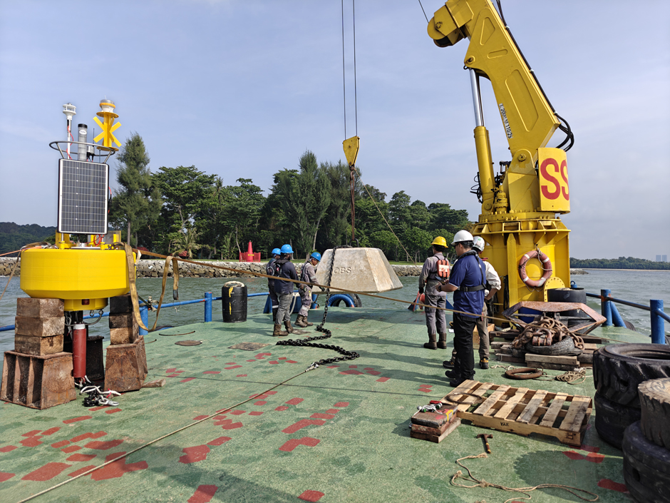
The 5.5 tonne concrete sinker is prepared for deployment off Kusu Island, Singapore. (Credit: Abhishek Datla)


0 comments