New Tide Gauges Bring Real-Time Ocean Data to Timor-Leste’s Shores
Timor-Leste is a growing country in Southeast Asia that occupies the eastern half of the island of Timor. Since its emergence in 2002 as the first new sovereign state of the 21st century, it has made “significant progress in key areas.”
In August 2025, two real-time oceanographic and meteorological systems were installed along Timor-Leste’s northern coastline. Part of a wider United Nations (UN) project, their enhanced monitoring is benefiting local navigation and region-wide emergency preparedness.
Abhishek Datla is Sales Manager at Elcee Instrumentation and Services, a Malaysian-based company that distributes oceanographic, environmental, and meteorological systems–including NexSens equipment–across Southeast Asia and beyond.
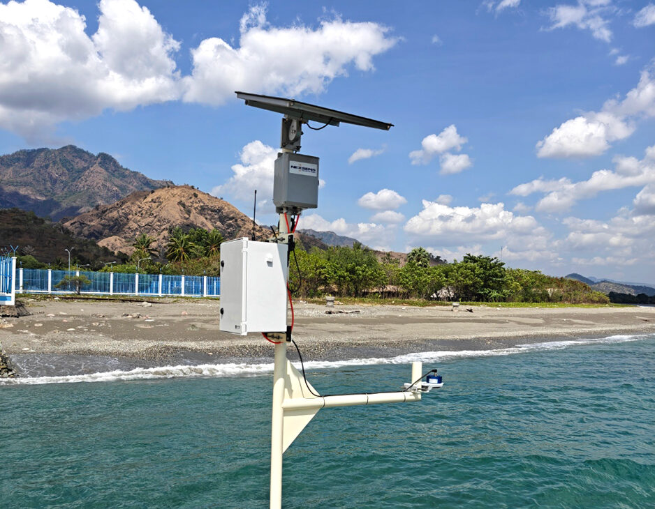
These systems are providing the first real-time tide data since legacy systems failed, providing valuable insight for local officials and regional RIMES monitoring. (Credit: Abhishek Datla)
Building Region-Wide Resilience
Formed in the aftermath of the 2004 Indian Ocean Tsunami, the Regional Integrated Multi-hazard Early Warning System (RIMES) is an intergovernmental institution that supports various member states to enhance monitoring networks and address gaps in multi-hazard early warning information.
Acting as the technical partner for a project led by the UN Environment Programme (UNEP) and funded by the Green Climate Fund, RIMES contacted Elcee for monitoring equipment to deploy in Timor-Leste.
“It’s a long-term project,” Datla highlights. “Timor-Leste already had real-time tide gauges installed by the Japanese International Cooperation Agency (JICA) many years ago, but they’re in disrepair, so RIMES is setting up a new Multi-Hazard Early Warning System.”
Preparations underway for system deployment. (Credit: Abhishek Datla)
A New System for Timor-Leste
Elcee provided a number of new monitoring systems for the Timorese project, including two radar water level systems.
The systems consist of a NexSens X3 data logger equipped with 4G cellular, a Geolux LX-80 radar water level sensor to measure tides and Seametrics PT12-BV for barometric pressure and temperature readings.
The systems were installed at two locations–one in Dili, the capital’s bustling harbor–and another in the exclave of Oecusse, some 400 km west. Both are port locations and have regular commercial and passenger traffic.
For this project, Datla explains that, “NexSens is ideal–you don’t have to worry about complicated wiring and junction boxes. It’s a weatherproof data logger, powered by its solar pack and pretty much plug and play.”
“It takes up very little space and runs for a long time with very little maintenance. It’s very easy to set up and install, and relatively cheap,” he adds.
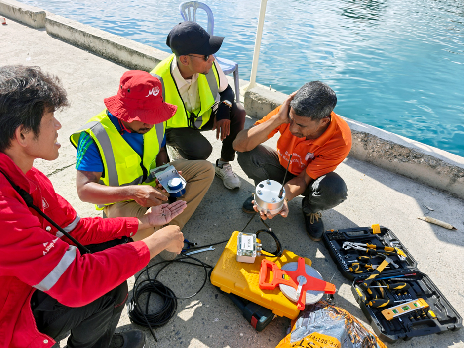
Alongside the fixed tide gauge systems, Elcee also provided a portable tide gauge to validate the real-time data and take spot measurements elsewhere. A wave measurement buoy has also been deployed in Dili harbor, measuring wave height, period and direction.

While on hand to support the deployment, Datla encouraged the teams who would be responsible for maintenance to be as hands-on as possible. (Credit: Abhishek Datla)
Empowering Communities
Datla was on hand to support the deployment of the tide gauge systems. Upskilling Timorese officials and empowering them to take ownership of the technology, including maintenance, was an important part of this process and will help to ensure the project’s sustainability and longevity.
“We conducted capacity-building sessions for the locals,” Datla says. “There were people from the Port Authority, the Maritime Police, the Navy, and the Ministry of Transport […] there were more than 30 people involved.”
“Before installation, we conducted a theory session, explaining about tides in general and the instruments,” he continues. “Then, during the installation, we tried to get them to do as much hands-on setting up as possible.”
Datla provided the team with an annual maintenance plan that assigned individuals to specific roles and additional troubleshooting guidance. He also remains in regular contact with teams on the ground via WhatsApp.

The Elcee team led capacity building sessions, empowering local officials to manage the maintenance of these systems independently. (Credit: Abhishek Datla)
Real-Time Data
Data from the tide gauge systems is transmitted every 10 minutes to RIMES servers, and this feeds into the Ocean State Forecast and Advisory System (OSFAS) model, which provides operational, customized ocean forecasts.
Originally, this was the only place data was going to be displayed. However, after installing the systems with the Timorese team, Datla demonstrated how to view and interpret the collected data on WQData LIVE and the group “really liked the dashboard.”
Preferring this for everyday use, the Timorese officials “created accounts on WQData LIVE and they all have it on their phones.”
The difference in platform reflects the data’s multifaceted use. For RIMES, it contributes to local and regional modelling of natural hazards and a better understanding of long-term changes—for example, those unfolding as a result of climate change.
For Timorese authorities accessing measurements on a day-to-day basis, this is their first real-time oceanographic and meteorological data since the legacy systems failed.
“They don’t want to have to rely on a tide chart from the internet, they want real-time data,” Datla explains. “They mainly need it for navigation and shipping.”

NexSens X3 data loggers equipped with 4G cellular transmit data on water level and weather conditions every 10 minutes. (Credit: Abhishek Datla)
Climate Change and the Importance of Data
Small Island Developing States (SIDS) and developing countries in Southeast Asia, like Timor-Leste, are prone to hydro-meteorological and geological hazards. Their effects severely undermine national growth and the livelihoods of local people–and climate change is increasing their frequency and intensity.
In 2021, Tropical Cyclone Seroja was followed by heavy rain. Catastrophic flash flooding and landslides affected all of Timor-Leste’s 13 municipalities, claiming over 40 lives. By the end of the 21st century, 100-year extreme precipitation events are projected to occur 3.28 times more frequently.
Despite the increasing exposure to more violent hazards, the world’s least developed countries and SIDS have less than 10 per cent of the data they need for effective alert and early warning systems.
This delineates the importance of RIMES, and the technology that enables collecting data at a high spatial and temporal frequency. Together, they represent a major step forward in safeguarding Timor-Leste’s coastline and its population.


0 comments