Predicting Harmful Algal Blooms in Green Bay’s Fox River
Green Bay, Wisconsin, has long faced water quality concerns, dating back decades to when the region was industrialized and waste was frequently flowing into the Fox River, a tributary of the bay. Nutrient loads from development and agriculture led to increases in primary production in the bay and northwestern Lake Michigan.
Today, most pollution comes from non-point sources, though Green Bay continues to suffer from algal blooms year after year. These blooms can impact human health as well as lead to declines in the lake’s fisheries.
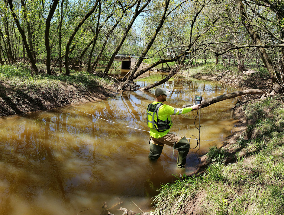
Hydrologic Technician Matthew Bach making a discharge measurement using an acoustic velocimeter at the Ashwaubenon Creek near Little Rapids, WI. (Credit: Jamie Velkoverh)
Why Monitor Green Bay Tributaries?
To remedy this, the US Geological Survey (USGS), in collaboration with the Green Bay Metropolitan Sewerage District (NEW Water), began working with watershed specialists to collect water samples and discharge data from the Ashwaubenon, Dutchman, and Silver Creek watersheds—tributaries of the Fox River, which drains into Green Bay.
“The aim is to better understand how an adaptive management approach using conservation practices affect total suspended solids (TSS) and phosphorus loads entering Green Bay,” states Matt Bach, a hydrologic technician for the USGS.
He continues, “Ultimately, the goal is to reduce sediment and nutrient discharge into Green Bay and improve water quality and continue monitoring efforts long term.”
In 2023, in cooperation with multiple agencies—Wisconsin Department of Natural Resources (WDNR), Great Lakes Restoration Initiative (GLRI), and the U.S. Army Corps of Engineers Chicago District (USACE)—the USGS launched a study to better characterize the extent and transport of HABs in the Fox River.
This project aims to improve understanding of HAB dynamics and support restoration efforts by addressing key science and data gaps that are essential for predicting and managing HABs in Green Bay.
Cutting-edge technologies are being used to provide critical data that can be used to better understand the dynamics of HABs in the Lake Winnebago-Fox River-Green Bay system. This information will be used by the WDNR to make decisions about managing HABs in the Lower Green Bay and Fox River Area of Concern (AOC).
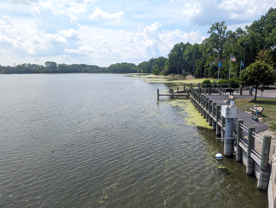
Harmful algal bloom data collection site at Lake Butte Des Mortes near Menasha, WI. (Credit: Matthew Bach)
Monitoring Water Level and Runoff in Fox River Tributaries
Monitoring stations are positioned at multiple points in the Ashwaubenon and Dutchman Creeks, both of which are tributaries of the Fox River. These systems are equipped to collect both stage (water level) and discharge data, as well as including passive integrated auto-samplers that capture runoff during high-water events.
Sensors and parameter selection for these systems are customized based on the monitoring site, varying based on environmental conditions and project goals like measuring nutrient loading, harmful algal blooms (HABs), or hydrologic extremes.
Stage data is collected using non-submersible pressure transducers paired with bubbler units, which use pressurized air bubbles fed through tubing installed in the water column to calculate a stage, or water depth data point.
Water samples are collected at most sites using a portable refrigerated sampler, which collects samples at set time intervals once the stage reaches past a certain threshold, such as a rain runoff event. During these events, the samplers collect data continuously, all of which is analyzed and compiled into the larger dataset.
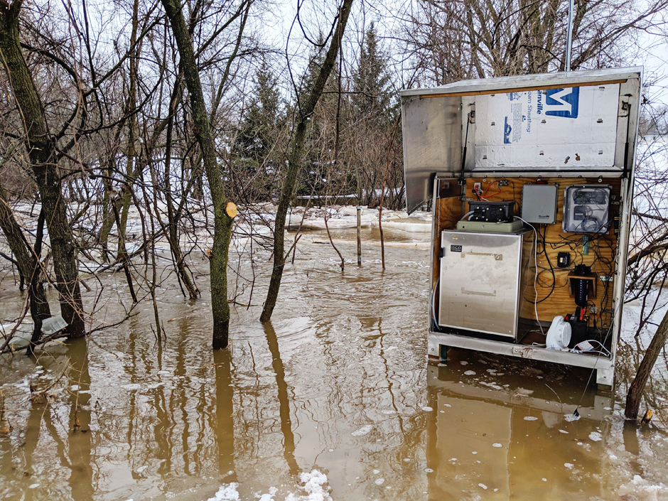
Stream gage enclosure at the Dutchman Creek near Ashwaubenon, WI, during extreme flows during spring ice melt runoff. (Credit: Matthew Bach)
The USGS also collects precipitation and water temperature data in order to help correlate rainfall with high-water events, which—according to Bach—improves predictive capabilities. This data is particularly useful during the winter for identifying ice buildup in river channels and accounting for this in the data.
HAB-related monitoring is done using five multi-parameter sondes with sensors for phycocyanin, chlorophyll a, specific conductance, turbidity, and temperature. The sondes are mounted on anchored buoys and measure the upper water column for surface blooms.
The buoys are located near banks for easy maintenance, and the measurements are used to calculate algal biomass and serve as indicators for HAB presence and intensity. These sites also include cell-enabled time-lapse cameras to track bloom formation and movement over time.
Data is collected in real-time and stored on dataloggers, paired with cellular modems for remote access.
For velocity measurements, handheld acoustic doppler velocimeters with a wading rod are used during low- or baseflow conditions. During high-flow events, acoustic Doppler current profilers are deployed on tether boats.
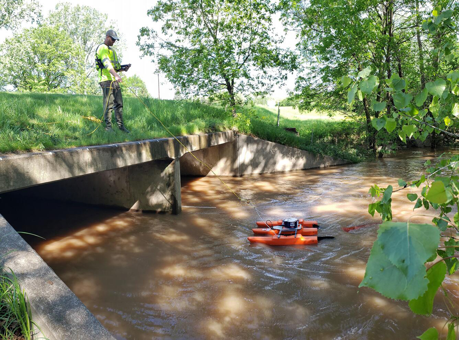
Hydrologic Technician Matthew Bach making a discharge measurement using an acoustic doppler current profiler (ADCP) at the Dutchman Creek near Ashwaubenon, WI. (Credit: Jamie Velkoverh)
Data Collection, Analysis, and Use
All of these efforts occur in tandem in order to collect a holistic view of the creeks and inputs into the Fox River. Bach manages both the data collection side of the projects as well as the analysis.
He explains, “My role also includes analyzing datasets, resolving discrepancies, and meeting project deadlines for data approvals. This often involves reviewing hydrographs to detect anomalies or quality concerns and applying corrections according to USGS protocols.”
He summarizes, “In short, I’m responsible for everything from installation and upkeep of field equipment to analyzing and validating the data we collect—ensuring its accuracy and usefulness.”
Included in this is accounting for any possible discrepancies in the data. A combination of real-time and discrete sampling, paired with regular maintenance and winterization, helps correct any measurement drifts or errors resulting from environmental conditions.
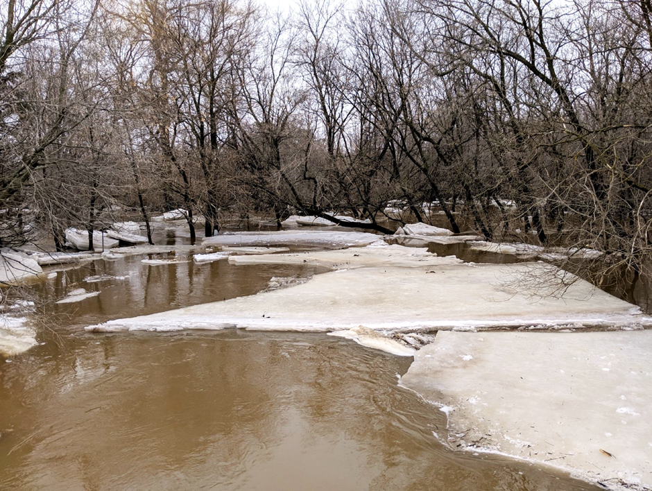
Ice backwater conditions during spring runoff at Ashwaubenon Creek near Little Rapids, WI, during extreme flows during spring ice melt runoff. (Credit: Matthew Bach)
“The biggest challenge we face is climate. Northeast Wisconsin sees significant seasonal variation, and many smaller tributaries freeze nearly solid in winter, complicating year-round monitoring,” explains Bach.
Freezing conditions in particular can cause equipment failure, complicating year-round monitoring. Bach details a few strategies the USGS uses to overcome these challenges.
First, cables are wrapped with heat tape to prevent freezing and sensors are deployed in deeper, well-mixed portions of the stream—”Beneath the ice but above sediment buildup,” describes Bach.
Due to the effects of ice backwater on discharge data, particularly in the spring during ice breakup, Bach notes that he prioritizes ADCP discharge measurements to improve accuracy. He explains, “The more reliable our discharge data, the better our nutrient load estimates.”
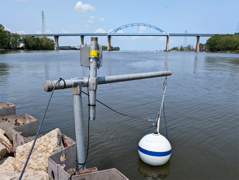
Deployed monitoring buoy housing a multiparameter sonde, overlooked by a camera, to detect harmful algal blooms forming in the Fox River in Green Bay, WI. (Credit: Matthew Bach)
Troubleshooting and Optimizing Data Collection
The process requires continuous problem-solving and quick responses to issues that may arise. Minimizing errors and responding to sensor failures with supplemental monitoring are essential to ensuring that the ever-growing datasets are of good quality.
“With more than 20 active sites in our area, it’s common to walk into the office not knowing what the day will hold. Equipment failures are inevitable, but having the tools and knowledge to troubleshoot and fix issues in the field is incredibly satisfying,” states Bach.
He continues, “Whether it’s diagnosing a faulty sensor, repairing a bubbler line in sub-zero conditions, or collecting water samples or discharge data during a storm, every challenge offers an opportunity to learn and grow.”
A Wisconsin-native, Bach grew up around the Great Lakes, and since starting his work with the USGS in 2014, he has seen the monitoring program expand over the years. Over time, the program has become more comprehensive in observing conditions in the surrounding watersheds in order to protect public health and local water resources overall.
“It’s that sense of purpose—knowing the data we collect contributes to protecting public health, infrastructure, and the environment—that makes this work so fulfilling,” affirms Bach.
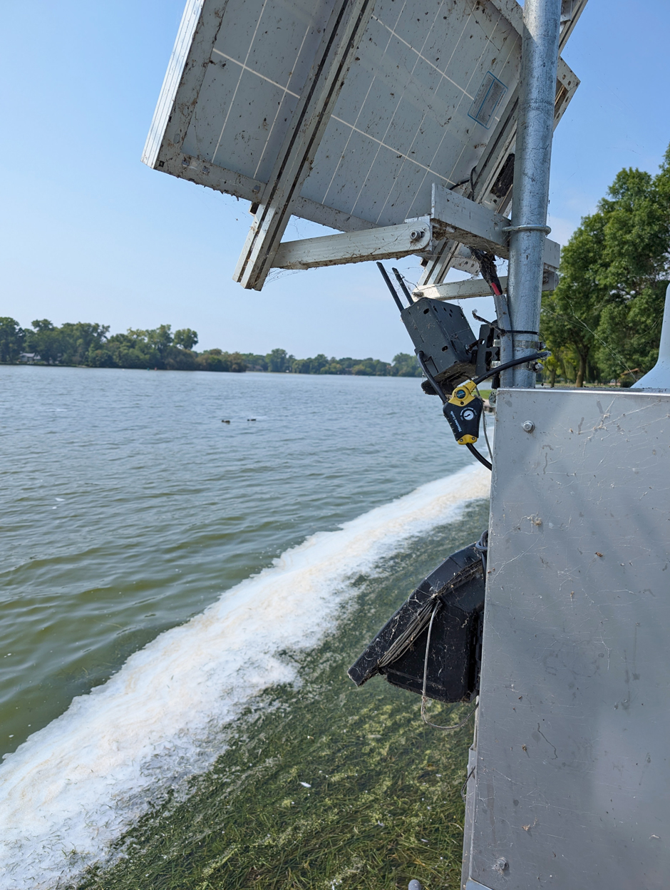
Harmful algal bloom image collection site at Lake Winnebago near Menasha, WI (Photo Cred: Matthew Bach)
One Comment
Leave a Reply


Jerry "Chips" Davidsavor
December 3, 2025 at 10:02 AM
Great work Matt! Thank you for your work in monitoring and improving the water quality of the Fox River and Green Bay. It is a great fishery!