

Monitoring Scour at Bridges and Offshore Structures
Why Monitoring Matters
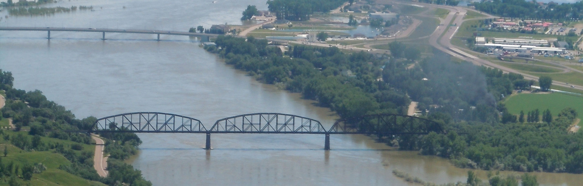
Streambed scour is the erosion of sediment at the base of bridge piers, abutments and other underwater structures. Scouring can occur in any area of water flow, from streams and rivers to tidal estuaries. This erosion is caused by water flow, and increases during times of swift, high flow, such as during a flood. The faster the flow, the more sediment that can be carried away. The holes left behind in the riverbed by scour can compromise the safety of the structure.
Bridge scour monitoring, and scour monitoring at other offshore structures can identify and prevent disasters before they strike. While scour can occur slowly over time, flood events can cause rapid scouring, to the point of structure failure. As scour alters the elevation of the riverbed at a pier, a monitoring system can indicate when a bridge becomes structurally deficient and dangerous due to sediment erosion. While monitoring does not make a structure less susceptible to scour, a real-time alert can be sent out if a bridge becomes scour critical and must be closed.
The Federal Highway Administration (FHWA) requires every state to identify, monitor, and improve any highway bridge where scour is or could become critical. As scour affects more than just highway bridges, it is recommended to monitor other bridges and offshore structures as well. A real-time monitoring system can observe scour progression and indicate when and what actions must be taken to maintain structural integrity. The FHWA has published several reports regarding scour monitoring and recommended procedures through the National Cooperative Highway Research Program (NCHRP) and the Hydraulic Engineering Circular. Often in cooperation with state Departments of Transportation and the U.S. Geological Survey, real-time scour monitoring systems can be installed to warn of scour-critical conditions. These monitoring systems can be used to detect the need for immediate mitigation measures during a flood event or simply to establish a schedule for structural countermeasures.
Bridge Scour: Overview of FHWA Guidance and HEC manuals
 Flood-related scour is responsible for the vast majority of bridge failures and closings across the country. While most bridges can withstand typical water flows, 50-year, 100-year and 500-year floods can cause scour-critical status or bridge collapse. A scour-critical status is based on current instability due to scour or the potential of instability due to scour. To determine the extent of at-risk structures, the Federal Highway Administration (FHWA) established the National Bridge Inventory (NBI) and requires states to report on the conditions of public bridges.
Through the NBI, structurally-deficient or scour-critical bridges must be identified and a plan of action for monitoring and scour countermeasures must be developed. Monitoring plans are further outlined and discussed in the FHWA’s three-set guidance manuals. These manuals are published in the Hydraulic Engineering Circular (HEC) and are intended to be referenced in sequence.
The first manual is called Stream Stability at Highway Structures (HEC-20), and assists in initial data collection and monitoring for water channel classification and assessment of channel instability. The second manual, Evaluating Scour at Bridges (HEC-18), establishes procedures for hydrologic and hydraulic analysis of waterways. This manual further evaluates the existing risk and potential scour at the structure. The final guidance manual, FHWA’s Bridge Scour and Stream Instability Countermeasures: Experience, Selection, and Design Guidance (HEC-23), provides options for monitoring and combating bridge scour. HEC-23 details the need for a monitoring strategy, preferably in real time, within the countermeasure proposal.
In compliance with the NBI and often in conjunction with the U.S. Geological Survey, state DOTs can establish a thorough plan of action for scour-critical bridges within their boundaries. This plan of action is developed for each bridge individually, detailing the best countermeasure methods to remedy current bridge scour and prevent or slow its future expansion. To this end, the FHWA guidance manuals list monitoring, inspection and maintentence as the most effective scour countermeasures.
When implementing this plan of action, a real-time monitoring solution is recommended as it provides immediate data for timely evaluations and countermeasure responses. Monitoring is particularly important during and after flood events, though regular monitoring can alert bridge owners to potential problem areas before scour becomes dangerous. Several National Cooperative Highway Research Program (NCHRP) reports substantially expound on the strength of scour monitoring as an effective countermeasure. Three of these reports (NCHRP Report 396, 397a, 397b) delve into the available scour monitoring instruments and their usefulness based on stream conditions, bridge structure and other feasibility factors. Further reports provide detailed assistance on dealing with other environmental elements, such as debris, and the subsequent effect on bridge scour.
However, scour monitoring, even in real time, does not erase scour-critical status. It is intended as a tool for early scour detection, improved response time and determining which action should be undertaken to counter scour.
Read the complete FHWA’s Stream Stability at Highway Structures (HEC 20)
Read the complete FHWA’s Evaluating Scour at Bridges (HEC 18)
Read the complete FHWA’s Bridge Scour and Stream Instability Countermeasures: Experience, Selection, and Design Guidance (HEC 23)
Sediment: The Foundation of Scour
 Sediment is the collection of organic and inorganic particles that can be moved by water and wind. In water quality terms, sediment typically refers to mineral-based matter such as clay, silt, sand and gravel that are carried into the water from the local environment. The amount of sediment and distance that these particles travel is known as the sediment transport rate.
Sediment transport, and consequently erosion and deposition, are dependent on water flow. When water flow increases (whether by volume or velocity), the forces acting on a riverbed also increase. During high-flow events, such as floods and snow melt, the amount of sediment picked up by the higher flow rate increases, increasing the sediment transport rate and causing erosion. While sediment transport and deposition are an important part of most aquatic ecosystems, the constant erosion can pose a risk to man-made structures.
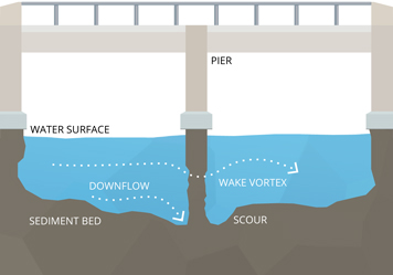
Scour (riverbed erosion at a structure) is a consequence of excessive sediment transport. When sediment erosion occurs at the base of a bridge pier or other structure, it can cause safety concerns due to structural compromises.
Learn more in the Sediment Transport and Deposition section.
A Real-Time Solution
 One of the most efficient and cost-effective countermeasures for scour is real-time monitoring. While monitoring does not prevent or eradicate bridge scour, it can provide adequate warning of scour-critical conditions. Scour monitoring instruments will measure sediment level or bed elevation near a pier or other structure. As sediment is eroded away by water flow, the elevation decreases, and the instrument will measure the sediment level change. If a critical level is reached, a signal can be transmitted to the necessary personnel for bridge closure.
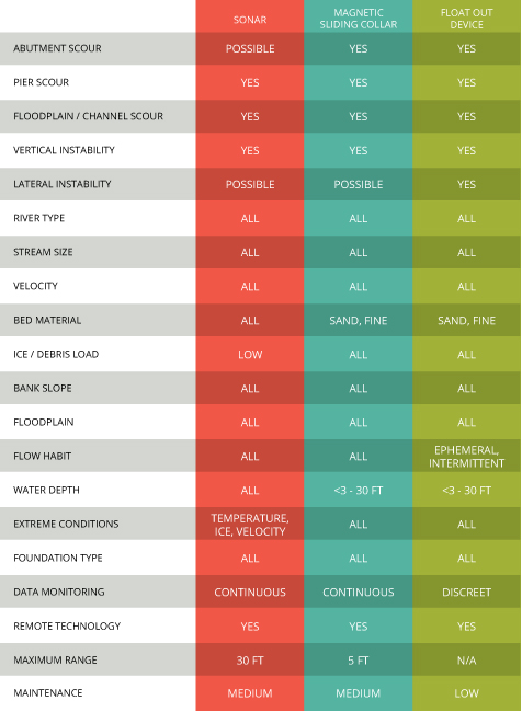
While portable scour monitoring instruments exist, fixed instruments can provide more frequent data in real time. It is worth noting that no single scour monitoring method can be universally applied to every site regardless of environmental conditions. However, the three scour monitoring instruments listed here (sonar, magnetic sliding collar, float-out device) were tested by the NCHRP research team and are in common use.
Learn more in the Scour Monitoring Equipment section.
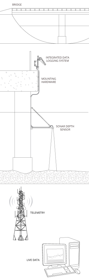
Typical Scour Monitoring System
Scour monitoring is a cost-effective and recommended component of any bridge scour countermeasure strategy. A monitoring strategy can be used to detect potential scour problem areas and continually survey current scour progress. This is usually done with a monitoring station mounted to the bridge structure, with one or multiple sonar sensors providing data.
To be effective, bridge scour should be continuously monitored with the data made available in real time. The easiest and most efficient way to do this is with an integrated telemetry system. A data logger can support multiple sonar and water level sensors and log scour data from each at pre-defined intervals. With telemetry, whether radio, cellular or satellite, the system can then securely transmit the scour data to the Internet in real time for viewing from any computer.
Integrated data logging and telemetry stations are customizable based on bridge scour monitoring needs. The integrated system, whether mounted on a bridge, pier, or along the riverbank can connect to and support multiple sensors, even when they are mounted on different piers. All equipment is powered via a central battery and recharging solar panel system. With multiple telemetry options to choose from, continuous real-time data are available from any computer. This ensures that the scour conditions are constantly monitored, and any control or countermeasures can be implemented immediately if the scour becomes critical.
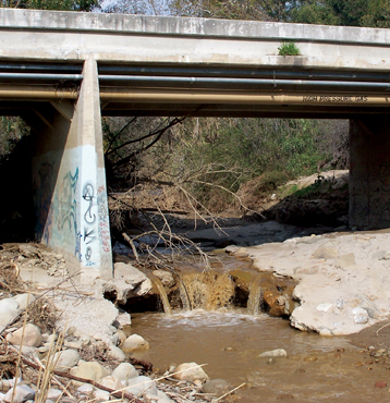
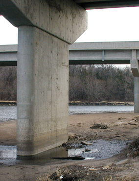
Bridge: Piers and Abutments
 While scour can occur at any underwater structure, highway bridges are most likely to be deemed scour critical and require monitoring. Scour can be found at both piers and abutments of a bridge. If too much sediment is washed away, the bridge may collapse.
Integrated Data Logging System
An integrated data logging system is a real-time monitoring station that houses the data logger, telemetry module, and power/charging supply. Since it is generally cost-prohibitive to run AC power to the monitoring location, integrated solar panels are used to continuously charge the 12VDC battery for autonomous operation.
Mounting Hardware
Data loggers can be mounted directly to the pier/abutment or to a pole on the bridge, depending on the location and recommended monitoring plan. The sonar sensor(s) should be mounted to a bracket on the pier or abutment, while water level or flow sensor(s) should be deployed in a fixed pipe.
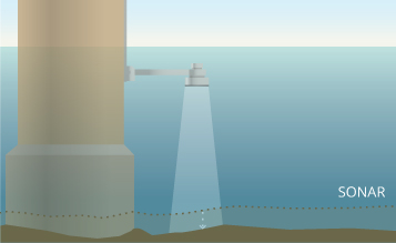
Sonar Depth Sensor
Sonar instruments are commonly used to monitor scour as they measure the distance the riverbed. A sonar depth sensor can frequently “ping” the river bottom to detect if sediment has shifted or been washed away (changing the bed elevation). Single-beam sonar are best used for monitoring one location, while multi-beam sonar can monitor a wider area.
Water Level Sensor
Water level sensors are often included in a scour monitoring plan for more comprehensive data. These sensors measure changes in water level, which can indicate a flood event or abatement. With several technologies available including non-contact, vented and absolute, a water level sensor can be easily integrated into a scour monitoring program.
Telemetry
Telemetry provides scour monitoring data in real time by sending the data to a central computer or web-based datacenter. The wireless communication can be radio-to-shore, cellular or satellite based.
Live Data
Scour data can be viewed instantly at any time 24/7 through an online datacenter. This data can be viewed in real-time, or as a graph to see trends. Automated alerts can be sent in real time via text or email when scouring causes a structure to become dangerous.
Scour Monitoring as a Countermeasure
 The number, location, and even method of scour monitoring stations will vary due to local stream and bridge conditions. Before installing any monitoring systems, a channel-stability assessment should be conducted. For most bridges in the US, this can be included in the examination required by the National Bridge Inspection Standards. This assessment will help determine what (if any) scour countermeasures are necessary. The site and structure should first be examined for scour-critical factors, such as existing scour, channel stability (stream and bed type, erodible banks), and other environmental characteristics. Short and long-term geomorphic changes, coupled with bridge design and local site conditions can all affect scour potential at a structure.
Scour-Critical Structures
A structure is considered scour critical if the abutment(s) or pier foundation(s) are coded unstable. This classification can be due to current, observed scour or a high potential for scour as determined by the assessment. Scour-critical structures can include more than bridges with existing damage or migrating streams. Presently sound bridges with no observable scour, but that have a future scour risk due to calculations of 100-year flood conditions, are also classified as scour critical. Once a structure has been deemed scour critical by a bridge inspection or channel-stability assessment, the next step is to determine which countermeasures are most efficient and cost-effective for the location.
For most sites, scour monitoring is considered an effective component of the plan of action, if not the sole countermeasure in use. Scour-critical bridges with no existing scour and a minimum risk may only need a monitoring component as the countermeasure plan of action. Older structures with unknown foundations and low-level risk may also only have a scour monitoring countermeasure in their plan of action. Though a bridge’s approved plan of action may only comprise scour monitoring, this does not fix or erase the problem. The bridge will remain coded as a scour-critical bridge unless other hydraulic or structural countermeasures are also implemented.
System Location and Deployment
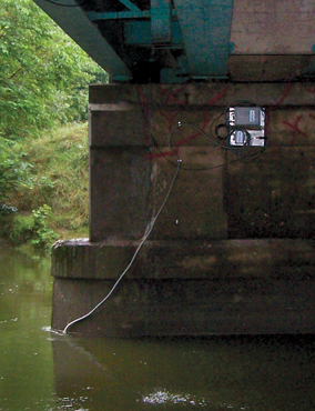
Typically, scour monitoring stations are mounted directly to the bridge structure or near the foundation bed. This allows them to monitor high-risk areas that are vulnerable to scour. While multiple instruments may be impractical on small, low-traffic structures, it may be cost-effective to monitor multiple piers for scour on a larger, high-traffic bridge. However, due to budget constraints, most structures will only have one monitoring station.
Mounted scour monitoring systems can be set up anywhere that offers a supportive foundation. Common deployment locations include pole or wall mounting directly to a bridge deck or pier. For ease of access, the data logger is often mounted on the bridge deck, while the sensors are mounted below. The system can include a locking stainless steel enclosure to protect the data logger and telemetry modem from harsh weather and vandalism. Connected sensors run from the station down the pier, into or over the water. Sonar sensors are mounted out from the pier face, while magnetic sliding collars are driven into the sediment at the base of the pier. Float-out devices are not connected at all, but are buried near the bridge foundation. These devices should still have a signal-receiving unit on the bridge deck or mounted nearby to log when the instrument becomes uncovered.
Selecting the Instrumentation
Scour monitoring as a countermeasure is used to survey scour progress and identify potential scour before it becomes a hazard. Based on environmental conditions, including river type, flow rate and bed material, one instrument may be better suited than others. Whether or not the monitoring countermeasure is intended as a short or long-term solution will also play a role in instrument selection. If conditions and budget allow for it, multiple instruments may be used to cover all situations, as well as to provide data redundancy and quality assurance. The chart below can be consulted to assist in determining which instrument would be best suited to a structure based on monitoring needs and river conditions.
Some plans of action may require additional monitoring beyond scour and sediment erosion. Adding other hydraulic variable sensors and structure monitors provides useful data for scour research and offer a more thorough approach to scour monitoring. Extra instrumentation often includes water level sensors (stage sensors), velocity or flow sensors, temperature sensors and tiltmeters. The use of additional sensors is more common with grant-funded or USGS-partnered projects, as the supplementary data can be collected for more accurate scour predictions and modeling. These additional sensors can easily be connected to the monitoring station data logger for data transmission.
Data Management
 A major part of bridge scour monitoring is the need for raw data. While it is possible to visit a site to periodically measure riverbed elevation, a real-time scour monitoring system is generally more cost-effective. The ability to frequently measure, log and download the monitoring data in real time means more raw elevation data for more accurate sediment transportation models. Real-time alerts by text or email also ensure a faster response time when adverse conditions arise.
Learn more in the Monitoring Equipment section.
Quality Assurance
To ensure and maintain structural safety, accurate data are important. Accurate scour information can help prevent structural failure by keeping bridge owners and other personnel aware of scour-critical conditions. Ideally, all equipment should meet or exceed the NCHRP’s desirable criteria for sensor quality and robustness. In addition, best practice recommends regular maintenance of sensors and equipment to prevent damage and interference from debris or shifting sediment conditions. If a budget allows it, redundancy is also recommended to confirm that all sensors are operating within specifications.
System Maintenance
 The majority of fixed scour monitoring systems require regular maintenance. Whether the main instrument in use is a sonar sensor or a magnetic sliding collar, the equipment will need to be checked for functionality and to remove debris. While most scour monitoring instruments do not require calibration, the quality of data can be affected by external influences, particularly debris. The exception is float-out devices, as they cannot be accessed while they are installed.
For sonar-based monitoring systems, the sensor face should be kept clean and the setup should be regularly checked to prevent damage due to vandalism or above-water debris. Magnetic sliding collar systems are harder to maintain as they are below the surface of the water. However, it is extremely important to inspect the equipment regularly, particularly in waters with risk of biological growth (algae or barnacles). Biofouling can interfere with readings and damage the equipment if not removed.
Data loggers should also be included in the maintentence check. The enclosure dessicant pack should be replaced regularly to prevent moisture damage to the electronics, and the battery may need to be replaced every three to five years.
Ideally, a scour monitoring system should be installed in such a way as to protect the sensors and instruments from damage. This can include a deployment pipe or other robust material to guard the equipment from debris. For structure-mounted systems or data loggers, a locked enclosure can help deter vandalism.
For greater details regarding maintenance requirements, the manufacturer’s user manual and the HEC guidelines should be referenced.
Mandatory Monitoring System Criteria
 The National Cooperative Highway Research Program (NCHRP) developed four mandatory criteria and six desirable criteria for any scour monitoring system. The required benchmarks were established as necessary for a successful monitoring application, while the desirable conditions will assist in effectiveness and efficiency. During the NCHRP’s testing, both sonar and sliding collar systems were thoroughly tested to meet all of the mandatory and desirable criteria. While the trialed float-out device also met the requirements, it was not as thoroughly tested.
Mandatory criteria
- • Capability for installation on or near a bridge pier or abutment
- • Ability to measure maximum scour depth within an accuracy of +/- 1 ft
- • Ability to obtain scour depth readings from above water or from a remote site
- • Operable during storm and flood conditions
Desirable criteria
- • Capability to be installed on most existing bridges or during construction of new bridges
- • Capability to operate in a range of flow conditions
- • Capability to withstand ice and debris
- • Relatively low cost
- • Vandal-resistant
- • Operable and maintainable by highway maintenance personnel
The NCHRP report stressed that while some methods were more applicable than others, no single instrument will be the best option for any and every site. The best scour monitoring system should be chosen based on site-specific bridge conditions, environmental conditions, and potential for other influences.
Recommended Equipment
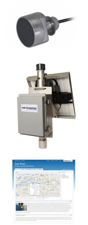 While there are a variety of scour monitoring instruments to choose from, some stand out above the rest. Fondriest Environmental has selected these products as the best in their field for their accuracy, dependability and value. Together, they provide an innovative and responsive real-time scour monitoring system. The Airmar EchoRange SS510 Smart Sensor is a low-cost depth sonar with digital output for scour and sediment transfer studies. The sensor features a robust stainless steel housing with 1/2″-14 NPS threads for convenient mounting. The NexSens MAST data logging system arrives fully assembled, tested and operational with integrated solar power and a choice of real-time radio, cellular, and satellite communications. Alone, real-time data are good, but with remote data collection, 24/7 access from any computer, instant alarm notifications and trend tracking, the intuitive WQData LIVE takes real-time data to the next level.
Learn more about these products:
- Airmar EchoRange SS510 Smart Sonar Depth Sensor
- NexSens MAST Wireless Telemetry Systems
- NexSens WQData LIVE Web Datacenter
Cite This Work
Fondriest Environmental, Inc. “Monitoring Scour at Bridges and Offshore Structures.” Fundamentals of Environmental Measurements. 5 Nov. 2014. Web. < https://www.fondriest.com/environmental-measurements/environmental-monitoring-applications/monitoring-scour-bridges-offshore-structures/ >.
Additional Information


